FAA INFORMATION EFFECTIVE 16 APRIL 2026
Location
| FAA Identifier: | OVE |
| Lat/Long: | 39-29-16.1500N 121-37-19.1560W
39-29.269167N 121-37.319267W
39.4878194,-121.6219878
(estimated) |
| Elevation: | 194.2 ft. / 59.2 m (surveyed) |
| Variation: | 16E (1990) |
| From city: | 3 miles SW of OROVILLE, CA |
| Time zone: | UTC -7 (UTC -8 during Standard Time) |
| Zip code: | 95965 |
Airport Operations
| Airport use: | Open to the public |
| Activation date: | 04/1940 |
| Control tower: | no |
| ARTCC: | OAKLAND CENTER |
| FSS: | RANCHO MURIETA FLIGHT SERVICE STATION |
| NOTAMs facility: | OVE (NOTAM-D service available) |
| Attendance: | MON-SAT 0800-1700 |
| Pattern altitude: | 994.2 ft. MSL |
| Wind indicator: | lighted |
| Segmented circle: | yes |
| Lights: | ACTVT REIL RWY 02 & 20; PAPI RWY 02, 13, 20 & 31; HIRL RWY 02/20 & RWY 13/31 - CTAF. |
| Beacon: | white-green (lighted land airport)
Operates sunset to sunrise. |
Airport Communications
| CTAF/UNICOM: | 122.8 |
| WX ASOS: | 121.425 (530-533-5792) |
| NORCAL APPROACH: | 125.4 |
| NORCAL DEPARTURE: | 125.4 |
Nearby radio navigation aids
| VOR radial/distance | | VOR name | | Freq | | Var |
|---|
| MYVr338/23.5 | | MARYSVILLE VOR/DME | | 110.80 | | 16E |
| ILAr019/31.3 | | WILLIAMS VORTAC | | 114.40 | | 18E |
Airport Services
| Fuel available: | 100LL JET-A |
| Parking: | tiedowns |
| Airframe service: | MAJOR |
| Powerplant service: | MINOR |
| Bottled oxygen: | NONE |
| Bulk oxygen: | NONE |
Runway Information
Runway 2/20
| Dimensions: | 6020 x 100 ft. / 1835 x 30 m |
| Surface: | asphalt, in good condition |
| Weight bearing capacity: | | Single wheel: | 47.0 | | Double wheel: | 90.0 |
|
| Runway edge lights: | high intensity |
| RUNWAY 2 | | RUNWAY 20 |
| Latitude: | 39-28.730923N | | 39-29.562783N |
| Longitude: | 121-37.908488W | | 121-37.211985W |
| Elevation: | 181.4 ft. | | 184.5 ft. |
| Traffic pattern: | left | | left |
| Runway heading: | 017 magnetic, 033 true | | 197 magnetic, 213 true |
| Markings: | nonprecision, in good condition | | nonprecision, in good condition |
| Visual slope indicator: | 2-light PAPI on left (3.00 degrees glide path) | | 2-light PAPI on left (3.00 degrees glide path)
DOES NOT PRVD OBSTN CLNC BYD 3 NM. |
| Runway end identifier lights: | yes | | yes |
| Touchdown point: | yes, no lights | | yes, no lights |
Runway 13/31
| Dimensions: | 3540 x 100 ft. / 1079 x 30 m |
| Surface: | asphalt, in fair condition |
| Weight bearing capacity: | | Single wheel: | 19.0 | | Double wheel: | 31.0 |
|
| Runway edge lights: | high intensity |
| RUNWAY 13 | | RUNWAY 31 |
| Latitude: | 39-29.712295N | | 39-29.242025N |
| Longitude: | 121-37.131725W | | 121-36.686943W |
| Elevation: | 192.7 ft. | | 176.7 ft. |
| Traffic pattern: | left | | left |
| Runway heading: | 128 magnetic, 144 true | | 308 magnetic, 324 true |
| Markings: | basic, in fair condition | | basic, in fair condition |
| Visual slope indicator: | 2-light PAPI on left (3.00 degrees glide path) | | 2-light PAPI on left (3.00 degrees glide path) |
| Runway end identifier lights: | no | | no |
| Touchdown point: | yes, no lights | | yes, no lights |
| Obstructions: | none | | 20 ft. trees, 600 ft. from runway, 200 ft. left of centerline, 20:1 slope to clear |
Airport Ownership and Management from official FAA records
| Ownership: | Publicly-owned |
| Owner: | CITY OF OROVILLE
1735 MONTGOMERY ST
OROVILLE, CA 95965
Phone 530-538-2405 |
| Manager: | CODY NISSEN
1735 MONTGOMERY ST.
OROVILLE, CA 95965
Phone 530-538-2490 |
Additional Remarks
| - | TWY FROM RY 02/20 TO GOLF COURSE/RESTAURANT TIEDOWNS 20 FT WIDE WITH NO SHOULDERS. |
| - | FIREFIGHTING ACFT INVOF ARPT MAY-OCT. |
| - | FOR ARPT INFO MON-FRI CTC (530) 538-2420. |
| - | FOR CD CTC NORCAL APCH AT 916-361-6874. |
Instrument Procedures
NOTE: All procedures below are presented as PDF files. If you need a reader for these files, you should download the free Adobe Reader.NOT FOR NAVIGATION. Please procure official charts for flight.
FAA instrument procedures published for use from 16 April 2026 at 0901Z to 14 May 2026 at 0900Z.
IAPs - Instrument Approach Procedures |
|---|
| RNAV (GPS) RWY 02 | |
download (231KB) |
| VOR-A | |
download (173KB) |
| NOTE: Special Take-Off Minimums/Departure Procedures apply | |
download (227KB) |
Other nearby airports with instrument procedures:
KCIC - Chico Regional Airport (21 nm NW)
KBAB - Beale Air Force Base (23 nm S)
KMYV - Yuba County Airport (24 nm S)
O08 - Colusa County Airport (25 nm SW)
KWLW - Willows/Glenn County Airport (28 nm W)
|
|

Road maps at:
MapQuest
Bing
Google
| Aerial photo |
|---|
WARNING: Photo may not be current or correct

Do you have a better or more recent aerial photo of Oroville Municipal Airport that you would like to share? If so, please send us your photo.
|
| Sectional chart |
|---|
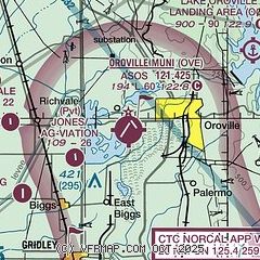
|
CAUTION: Diagram may not be current

| Airport distance calculator |
|---|
|
|
| Sunrise and sunset |
|---|
|
Times for 05-May-2026
| | Local
(UTC-7) | | Zulu
(UTC) |
|---|
| Morning civil twilight | | 05:34 | | 12:34 |
| Sunrise | | 06:04 | | 13:04 |
| Sunset | | 20:03 | | 03:03 |
| Evening civil twilight | | 20:32 | | 03:32 |
|
| Current date and time |
|---|
| Zulu (UTC) | 05-May-2026 07:18:32 |
|---|
| Local (UTC-7) | 05-May-2026 00:18:32 |
|---|
|
| METAR |
|---|
| KOVE | 050653Z AUTO 14004KT 10SM BKN044 OVC070 12/11 A2996 RMK AO2 RAB28E49 SLP148 P0002 T01220111
|
|
| TAF |
|---|
KBAB
23nm S | 050510Z 0505/0609 09010KT 9000 -SHRA BKN030 OVC080 QNH2994INS BECMG 0509/0510 10009KT 9999 VCSH BKN030 OVC080 QNH2992INS BECMG 0515/0516 12009KT 9999 NSW SCT040 OVC070 QNH2993INS BECMG 0600/0601 VRB06KT 9999 BKN070 QNH2991INS TX19/0600Z TN11/0505Z
|
|
| NOTAMs |
|---|
NOTAMs are issued by the DoD/FAA and will open in a separate window not controlled by AirNav.
|
|


