FAA INFORMATION EFFECTIVE 22 JANUARY 2026
Location
| FAA Identifier: | P08 |
| Lat/Long: | 32-56-09.6860N 111-25-35.3020W
32-56.161433N 111-25.588367W
32.9360239,-111.4264728
(estimated) |
| Elevation: | 1576.1 ft. / 480.4 m (surveyed) |
| Variation: | 12E (1985) |
| From city: | 5 miles SE of COOLIDGE, AZ |
| Time zone: | UTC -7 (year round; does not observe DST) |
| Zip code: | 85228 |
Airport Operations
| Airport use: | Open to the public |
| Control tower: | no |
| ARTCC: | ALBUQUERQUE CENTER |
| FSS: | PRESCOTT FLIGHT SERVICE STATION |
| NOTAMs facility: | PRC (NOTAM-D service available) |
| Attendance: | MON-FRI 0800-1700 |
| Wind indicator: | yes |
| Segmented circle: | yes |
| Lights: | DUSK-DAWN: ACTVT MIRL RWY 05/23 & 17/35 - CTAF. PAPI RWY 05 & 23; REIL 05 & 23 OPR CONSLY. |
| Beacon: | white-green (lighted land airport)
Operates sunset to sunrise. |
Airport Communications
| CTAF/UNICOM: | 123.075 |
| WX AWOS-3PT: | 119.350 (520-723-4920) |
| WX AWOS-3PT at CGZ (17 nm W): | 132.175 (520-836-3392) |
- APCH/DEP SVC PRVDD BY ALBUQUERQUE ARTCC (ABQ) ON FREQS 125.4/269.3 (GLOBE NR 2 RCAG).
Nearby radio navigation aids
| VOR radial/distance | | VOR name | | Freq | | Var |
|---|
| TFDr071/24.5 | | STANFIELD VORTAC | | 114.80 | | 12E |
| IWAr140/24.8 | | WILLIE VORTAC | | 113.30 | | 13E |
Airport Services
| Fuel available: | 100LL JET-A
100LL:SELF SVC WITH CREDIT CARD |
| Parking: | tiedowns |
Runway Information
Runway 5/23
| Dimensions: | 5564 x 150 ft. / 1696 x 46 m
25 FT PAVED SHOULDERS EACH SIDE. |
| Surface: | asphalt, in good condition |
| Weight bearing capacity: | | Single wheel: | 80.0 | | Double wheel: | 115.0 | | Double tandem: | 210.0 |
|
| Runway edge lights: | medium intensity |
| RUNWAY 5 | | RUNWAY 23 |
| Latitude: | 32-56.018757N | | 32-56.474185N |
| Longitude: | 111-26.124647W | | 111-25.180098W |
| Elevation: | 1549.5 ft. | | 1576.1 ft. |
| Traffic pattern: | left | | right |
| Runway heading: | 048 magnetic, 060 true | | 228 magnetic, 240 true |
| Markings: | nonprecision, in good condition | | nonprecision, in good condition |
| Visual slope indicator: | 2-light PAPI on left (3.00 degrees glide path) | | 2-light PAPI on left (3.00 degrees glide path) |
| Runway end identifier lights: | yes | | yes |
| Touchdown point: | yes, no lights | | yes, no lights |
Runway 17/35
| Dimensions: | 3872 x 75 ft. / 1180 x 23 m |
| Surface: | asphalt, in good condition |
| Weight bearing capacity: | |
| Runway edge lights: | medium intensity |
| RUNWAY 17 | | RUNWAY 35 |
| Latitude: | 32-56.358463N | | 32-55.719985N |
| Longitude: | 111-25.494942W | | 111-25.497822W |
| Elevation: | 1567.4 ft. | | 1575.3 ft. |
| Traffic pattern: | right | | left |
| Runway heading: | 168 magnetic, 180 true | | 348 magnetic, 000 true |
| Markings: | basic, in poor condition | | basic, in poor condition |
| Runway end identifier lights: | no | | no |
| Touchdown point: | yes, no lights | | yes, no lights |
| Obstructions: | 12 ft. brush, 327 ft. from runway, 75 ft. right of centerline, 10:1 slope to clear
CTLG OBSTN EXCEEDS 45 DEG SLOPE. | | 2 ft. brush, 201 ft. from runway |
Airport Ownership and Management from official FAA records
| Ownership: | Publicly-owned |
| Owner: | CITY OF COOLIDGE
131 W PINKLEY AVE
COOLIDGE, AZ 85128
Phone 520-251-1365 |
| Manager: | JAMES MYERS
CITY OF COOLIDGE MUNI ARPT, 131 WEST PINKLEY
COOLIDGE, AZ 85128
Phone (520) 723-6075 |
Additional Remarks
| - | FOR CD CTC ALBUQUERQUE ARTCC AT 505-856-4861. |
| - | PAJA TRNG ON ARPT; DROP ZONE ESE RWY 35. AEROBATIC ACT SFC-4500 FT 0.5 NM E. |
| - | LIVESTOCK & LRG MIL ACFT ON & INVOF ARPT. |
| - | R2310 OPS - AZARNG 138.15 |
Instrument Procedures
NOTE: All procedures below are presented as PDF files. If you need a reader for these files, you should download the free Adobe Reader.NOT FOR NAVIGATION. Please procure official charts for flight.
FAA instrument procedures published for use from 22 January 2026 at 0901Z to 19 February 2026 at 0900z.
IAPs - Instrument Approach Procedures |
|---|
| RNAV (GPS) RWY 23 | |
download (243KB) |
| VOR RWY 05 | |
download (188KB) |
| NOTE: Special Alternate Minimums apply | |
download (120KB) |
| NOTE: Special Take-Off Minimums/Departure Procedures apply | |
download (113KB) |
Other nearby airports with instrument procedures:
KCGZ - Casa Grande Municipal Airport (17 nm W)
KIWA - Mesa Gateway Airport (25 nm NW)
KCHD - Chandler Municipal Airport (28 nm NW)
P19 - Stellar Airpark (33 nm NW)
KAVQ - Marana Regional Airport (33 nm S)
|
|

Road maps at:
MapQuest
Bing
Google
| Aerial photo |
|---|
WARNING: Photo may not be current or correct
 Photo courtesy of AirNav, LLC
Photo taken 09-Nov-2013
looking north.
Photo courtesy of AirNav, LLC
Photo taken 09-Nov-2013
looking north.
Do you have a better or more recent aerial photo of Coolidge Municipal Airport that you would like to share? If so, please send us your photo.
|
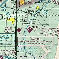
| Sectional chart |
|---|
|
CAUTION: Diagram may not be current

| Airport distance calculator |
|---|
|
|
| Sunrise and sunset |
|---|
|
Times for 24-Jan-2026
| | Local
(UTC-7) | | Zulu
(UTC) |
|---|
| Morning civil twilight | | 07:00 | | 14:00 |
| Sunrise | | 07:27 | | 14:27 |
| Sunset | | 17:49 | | 00:49 |
| Evening civil twilight | | 18:16 | | 01:16 |
|
| Current date and time |
|---|
| Zulu (UTC) | 24-Jan-2026 13:06:01 |
|---|
| Local (UTC-7) | 24-Jan-2026 06:06:01 |
|---|
|
| METAR |
|---|
| KP08 | 241255Z AUTO 10003KT 10SM OVC090 12/10 A2979 RMK AO2
|
KCGZ
17nm W | 241256Z AUTO 35005KT 10SM CLR 11/06 A2980 RMK AO2 SLP087 T01060056 PNO $
|
|
| TAF |
|---|
KIWA
25nm NW | 241134Z 2412/2512 VRB03KT P6SM FEW050 BKN060 OVC100 FM241500 14005KT P6SM SCT050 BKN060 OVC100 FM241900 26006KT P6SM SCT050 BKN060 FM250000 30009KT P6SM VCSH BKN060 TEMPO 2500/2503 30011G20KT FM250900 11005KT P6SM FEW060
|
|
| NOTAMs |
|---|
NOTAMs are issued by the DoD/FAA and will open in a separate window not controlled by AirNav.
|
|


