FAA INFORMATION EFFECTIVE 09 JULY 2026
Location
| FAA Identifier: | FBK |
| Lat/Long: | 64-50-15.4040N 147-36-52.1710W
64-50.256733N 147-36.869517W
64.8376122,-147.6144919
(estimated) |
| Elevation: | 448.6 ft. / 136.7 m (surveyed) |
| Variation: | 17E (2020) |
| From city: | 2 miles E of central business district of the associated city |
| Time zone: | UTC -8 (UTC -9 during Standard Time) |
| Zip code: | 99703 |
Airport Operations
| Airport use: | Private use, 24 HR PPR FOR TSNT - D317-353-7212/6514/C907-353-7212/6514. |
| Activation date: | 05/1949 |
| Control tower: | yes |
| ARTCC: | ANCHORAGE CENTER |
| FSS: | FAIRBANKS FLIGHT SERVICE STATION [907-474-0788] |
| NOTAMs facility: | FBK (NOTAM-D service available) |
| Attendance: | MON-FRI 1700-0800++ |
| Pattern altitude: | TPA R/W 1200 FT; F/W PISTON 1500 FT; F/W TURBINE 2000 FT. |
| Wind indicator: | yes |
| Segmented circle: | yes |
| Lights: | WHEN TWR CLSD ACTVT AFLD LGTS - CTAF |
| Beacon: | white-green (lighted land airport)
Operates sunset to sunrise. |
Airport Communications
| CTAF: | 125.0 |
| ATIS: | 134.25 |
| LADD GROUND: | 121.7 263.15 [1700-0800Z++ MON-FRI; EXC HOL.] |
| LADD TOWER: | 125.0 284.6 40.8FM [1700-0800Z++ MON-FRI; EXC HOL.] |
| FAIRBANKS APPROACH: | 125.35 ;180-359 127.1 ;360-179 |
| FAIRBANKS DEPARTURE: | 125.35 |
| BASE OPS: | 139.3 |
| EMERG: | 121.5 243.0 |
| IC: | 125.35 ;180-359 |
| PAR: | 121.3 134.1 237.5 |
| PMSV METRO: | 142.1 381.375 |
| RANGE CTL: | 38.3FM |
| WX ASOS at FAI (6 nm W): | 124.4 (907-621-7609) |
- VHF COMMUNICATIONS FROM TWR INTERMITTENT NE OF ARPT.
- REMOTE BRIEFING SVC AVBL: EILSON METRO (PAEI) 344.6.
- BASE OPS MON-FRI 1700Z-0200Z++
Nearby radio navigation aids
| VOR radial/distance | | VOR name | | Freq | | Var |
|---|
| FAIr056/10.4 | | FAIRBANKS VORTAC | | 108.60 | | 21E |
| NDB name | | Hdg/Dist | | Freq | | Var | | ID |
|---|
| CHENA | | 252/3.0 | | 257 | | 17E | | CUN | -.-. ..- -. |
Airport Services
| Fuel available: | J8 |
| Parking: | hangars |
Runway Information
Runway 7/25
| Dimensions: | 8575 x 150 ft. / 2614 x 46 m |
| Surface: | asphalt/concrete |
| Weight bearing capacity: | | Double wheel: | 38.0, SEASONAL CLIMATE COND EFCTS WEIGHT BRG CPTY. |
|
| Runway edge lights: | high intensity |
| Operational restrictions: | CTN: ROAD APCH END OF RWY 07 & 25. NO OVRNS. |
| RUNWAY 7 | | RUNWAY 25 |
| Latitude: | 64-50.244667N | | 64-50.268500N |
| Longitude: | 147-38.521500W | | 147-35.217500W |
| Elevation: | 442.8 ft. | | 447.9 ft. |
| Traffic pattern: | right | | left |
| Runway heading: | 072 magnetic, 089 true | | 252 magnetic, 269 true |
| Markings: | precision, in good condition | | precision, in good condition |
| Visual slope indicator: | 4-light PAPI on left (3.00 degrees glide path) | | 4-light PAPI on left (3.30 degrees glide path) |
| Approach lights: | ALSF1: standard 2,400 foot high intensity approach lighting system with centerline sequenced flashers (category I)
NSTD. | | ALSF1: standard 2,400 foot high intensity approach lighting system with centerline sequenced flashers (category I)
NSTD. |
| Runway end identifier lights: | yes | | yes |
| Touchdown point: | yes, no lights | | yes, no lights |
| Obstructions: | trees road, 500 ft. from runway, 10:1 slope to clear | | trees/road, 300 ft. from runway, 20:1 slope to clear |
Helipad H1
| Dimensions: | 50 x 50 ft. / 15 x 15 m |
| Surface: | asphalt/concrete, in good condition |
| Latitude: | 64-50.023667N | | |
| Longitude: | 147-35.358833W | | |
| Elevation: | 448.6 ft. | | |
| Traffic pattern: | left | | left |
| Markings: | none | | |
Helipad H4
| Dimensions: | 50 x 50 ft. / 15 x 15 m |
| Surface: | asphalt/concrete, in good condition |
| Latitude: | 64-49.960833N | | |
| Longitude: | 147-38.168500W | | |
| Elevation: | 448.6 ft. | | |
| Traffic pattern: | left | | left |
| Markings: | none | | |
Helipad H5
| Dimensions: | 50 x 50 ft. / 15 x 15 m |
| Surface: | asphalt/concrete, in good condition |
| Latitude: | 64-49.953500N | | |
| Longitude: | 147-37.465000W | | |
| Elevation: | 448.6 ft. | | |
| Traffic pattern: | left | | left |
| Markings: | none | | |
Helipad H6
| Dimensions: | 50 x 50 ft. / 15 x 15 m |
| Surface: | asphalt/concrete, in good condition |
| Latitude: | 64-49.998667N | | |
| Longitude: | 147-36.171500W | | |
| Elevation: | 448.6 ft. | | |
| Traffic pattern: | left | | left |
| Markings: | none | | |
Helipad H7
| Dimensions: | 50 x 50 ft. / 15 x 15 m |
| Surface: | asphalt/concrete, in good condition |
| Latitude: | 64-50.020833N | | |
| Longitude: | 147-35.756333W | | |
| Elevation: | 448.6 ft. | | |
| Traffic pattern: | left | | left |
| Markings: | none | | |
Airport Ownership and Management from official FAA records
| Ownership: | U.S. Army |
| Owner: | U.S. ARMY
U.S. ARMY FORCES COMMAND
ATLANTA, GA |
| Manager: | HQ 172 INFANTRY BRIGADE
FT RICHARDSON
ALASKA 99505
Phone 907-353-7022 |
Additional Remarks
| A39-07/25 | PCN JUN-FEB 111/F/B/W/T; PCN MAR-MAY 69/F/D/W/T. |
| A30A-25 | 15 FT ROAD 349 FT W OF DER; 23 FT RAILROAD TRACKS 556 FT W OF DER; 25 FT TREES 556 FT W OF DER. ROAD 387 FT FM DER RUNS THRU CLEAR ZONE PERPENDICULAR TO EXTDD CNTRLN; RIVER 477 FT FM DER RUNS THRU CLEAR ZONE PERPENDICULAR TO EXTDD CNTRLN. ROAD TFC IS CTLD BY ATCT WHEN OPN. |
| A30A-07 | ACTV RAILROAD 556 FT FM DER RUNS THRU CLEAR ZONE PERPENDICULAR TO CNTRLN; WHEN RAILROAD ACTV ATCT WILL ADVISE LNDG & DEP NA. 15 FT ROAD 387 FT E OF DER 349 FT FM DER RUNS THRU CLEAR ZONE PERPENDICULAR TO EXTDD CNTRLN; RIVER 556 FT FM DER RUNS THRU CLEAR ZONE PERPENDICULAR TO EXTDD CNTRLN. |
| A30A-H1 | DESIGNATED: HELIPAD S |
| A35 | T200; ST175; TT340; TDT714. |
| - | NORTH TFC PAT R/W & MQ-1 GRAY EAGLE ONLY; LRG ACFT - RAMP PRKG; SMALL ACFT TIE DOWN NOT AVBL. |
| - | BIRD ACT INVOF ARPT. |
| - | ALERT: NMRS NIGHT DEVICE ACFT OPS INVOF LADD AAF; EXP NMRS DIMLY LIT ACFT IN TANNANA FLATS & YUKON TRNG AREA DURG HR OF DARKNESS & WKDAY SEP-APR. |
| - | CTN: 100 FT MKD LGT POLE 3/4 NM SE. |
| - | MINS BASED ON FBK WX OBS. |
| - | ASOS 119.275 ASSOCD WITH R-2205 YUKON TRNG RANGE; ASOS 18.525 ASSOCD WITH R-2211 BLAIR LAKE TRNG RANGE. PMSV LMTD TO LINE OF SIGHT; RECEPTION BLW 5000 FT MSL LMTD FM 210-100 WI 100 NM BY TRRN, NO LMT ABV 5000 FT WI 50 NM; RECEPTION 3500-12000 FT LMTD FM 100-210 FM 50-100 NM BY TRRN, NO LMT ABV 12000 FT WI 100 NM. PMSV UNMON WHEN FBK TWR CLSD. SFC VIS RSTRD FM 020-050 DUE TO HNGR 1 & FM 250-350 DUE TO ATCT & BLDGS. |
| - | ALL HOP DAY VMC ONLY. |
| - | TWY A, B, C, D, E, F, G, SECTIONS OF N & S DO NOT HAVE SHOULDERS. |
| - | DE-ICE SVCS NOT AVBL. |
| - | FIRING RANGE S OF FLD FOR ADZY CTC ATCT OR OPS. |
| - | PMSV METRO - 142.1, 381.375 OR D317-353-7111/C907-353-7111. WX MON-SAT 0900Z-0900Z++ EXC HOL OR NOTAM. MEDEVAC AFT HR - C907-382-6518. |
| - | SVC: PAPI MAINT LAST WED OF MONTH 0900-1200/1800Z-2100Z++; PAPI NA DURG THIS TIME. |
| - | SVC: US CUSTOMS & INTL TRASH NOT AVBL. |
| - | EDGE LGTS TWY H & PTNS OF TWY N & S GTR THAN 10 FT FM TWY SIDE STRIPES. |
| - | GCA 121.3 118.05 276.4; MON-FRI 1700-0100++ EXC HOL. |
| - | RAPID HOT REFUELING POINTS OPS CLSD SAT, SUN, HOL; OTR TIMES BY NOTAM. AVN UNITS CTC THEIR OPS FOR COLD FUEL. |
| - | CTN: UNLGT TWRS IN ALPHA SOD CNTR INOP. |
| - | MED EVAC PAD FOR F/W AT OPS RAMP; R/W EVAC PAD AT HOSPITAL; 15 MIN NOTICE RQRD. |
| - | DURG WX STATION EVAC - 907-382-6518. |
| - | CTN: LGTD HWY PARL TO & N OF RWY 07/25 CAN BE CONFUSED WITH RWY. |
| - | INSPN BY DEPT OF ARMY. |
Instrument Procedures
NOTE: All procedures below are presented as PDF files. If you need a reader for these files, you should download the free Adobe Reader.NOT FOR NAVIGATION. Please procure official charts for flight.
FAA instrument procedures published for use from 09 July 2026 at 0901Z to 06 August 2026 at 0900Z.
IAPs - Instrument Approach Procedures |
|---|
| RNAV (GPS) RWY 25 | |
download (141KB) |
| NDB-A **CHANGED** | |
download (117KB) |
| Radar Approach Procedures available **CHANGED** | |
download (131KB) |
| NOTE: Special Take-Off Minimums/Departure Procedures apply | |
download (395KB) |
Other nearby airports with instrument procedures:
PAFA - Fairbanks International Airport (6 nm W)
PAEI - Eielson Air Force Base (17 nm SE)
PANN - Nenana Municipal Airport (41 nm SW)
PAHV - Healy River Airport (68 nm SW)
PABI - Allen Army Airfield (70 nm SE)
|
|

Road maps at:
MapQuest
Bing
Google
| Aerial photo |
|---|
WARNING: Photo may not be current or correct
 Photo by Bob McCormick
Photo taken 09-Apr-2010
Photo by Bob McCormick
Photo taken 09-Apr-2010
Do you have a better or more recent aerial photo of Ladd Army Airfield that you would like to share? If so, please send us your photo.
|
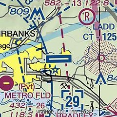
| Sectional chart |
|---|
|
| Airport distance calculator |
|---|
|
|
| Sunrise and sunset |
|---|
|
Times for 18-Jul-2026
| | Local
(UTC-8) | | Zulu
(UTC) |
|---|
| Morning civil twilight | | + | | + |
| Sunrise | | 04:04 | | 12:04 |
| Sunset | | 23:49 | | 07:49 |
| Evening civil twilight | | + | | + |
|
| Current date and time |
|---|
| Zulu (UTC) | 18-Jul-2026 20:23:04 |
|---|
| Local (UTC-8) | 18-Jul-2026 12:23:04 |
|---|
|
| METAR |
|---|
| PAFB | 181855Z AUTO 17004KT 10SM BKN070 16/10 A2992 RMK AO2 SLP137 T01590096
|
PAFA
7nm W | 181953Z 00000KT 10SM FEW030 FEW070 BKN110 15/09 A2994 RMK AO2 SLP142 T01500094 $
|
PAEI
17nm SE | 181855Z AUTO 00000KT 10SM FEW070 BKN080 15/09 A2993 RMK AO2 SLP139 T01500091 $
|
|
| TAF |
|---|
| PAFB | 180115Z 1801/1904 VRB06KT 9999 SCT075 BKN130 QNH2983INS BECMG 1900/1901 19006KT 9000 -SHRA VCTS SCT040 BKN050CB 620604 QNH2995INS TX20/1817Z TN10/1813Z LAST NO AMDS AFT 1801 NEXT 2014
|
PAFA
7nm W | 180530Z 1806/1912 22002KT P6SM SCT070 FM190000 18009KT P6SM SCT050 SCT100
|
|
| NOTAMs |
|---|
NOTAMs are issued by the DoD/FAA and will open in a separate window not controlled by AirNav.
|
|

