FAA INFORMATION EFFECTIVE 20 MARCH 2025
Location
| FAA Identifier: | RQE |
| Lat/Long: | 35-39-07.4000N 109-04-02.6000W
35-39.123333N 109-04.043333W
35.6520556,-109.0673889
(estimated) |
| Elevation: | 6742 ft. / 2055.0 m (surveyed) |
| Variation: | 09E (2020) |
| From city: | 1 mile S of WINDOW ROCK, AZ |
| Time zone: | UTC -6 (UTC -7 during Standard Time) |
| Zip code: | 86515 |
Airport Operations
| Airport use: | Open to the public |
| Activation date: | 04/1944 |
| Control tower: | no |
| ARTCC: | ALBUQUERQUE CENTER |
| FSS: | PRESCOTT FLIGHT SERVICE STATION |
| NOTAMs facility: | RQE (NOTAM-D service available) |
| Attendance: | MON-FRI 0800-1700 |
| Wind indicator: | lighted |
| Segmented circle: | no |
| Lights: | ACTVT REIL RWY 03 & 21; MIRL RWY 03/21 - CTAF. |
| Beacon: | yellow (unlighted seaplane base)
Operates sunset to sunrise. |
Airport Communications
| CTAF/UNICOM: | 122.8 |
| WX ASOS: | 118.325 (928-810-7235) |
| WX ASOS at GUP (16 nm SE): | 118.375 (505-726-8232) |
- APCH/DEP SVC PRVDD BY ALBUQUERQUE ARTCC (ZAB) ON FREQS 124.325/288.25 (ZUNI RCAG).
Nearby radio navigation aids
| VOR radial/distance | | VOR name | | Freq | | Var |
|---|
| GUPr304/14.2 | | GALLUP VORTAC | | 115.10 | | 14E |
Airport Services
| Parking: | tiedowns |
| Airframe service: | NONE |
| Powerplant service: | NONE |
| Bottled oxygen: | NONE |
| Bulk oxygen: | NONE |
Runway Information
Runway 3/21
| Dimensions: | 7000 x 75 ft. / 2134 x 23 m |
| Surface: | asphalt, in good condition |
| Weight bearing capacity: | | Single wheel: | 30.0 | | Double wheel: | 45.0 | | Double tandem: | 75.0 |
|
| Runway edge lights: | medium intensity |
| RUNWAY 3 | | RUNWAY 21 |
| Latitude: | 35-38.646233N | | 35-39.601883N |
| Longitude: | 109-04.438300W | | 109-03.646817W |
| Elevation: | 6701.6 ft. | | 6742.0 ft. |
| Traffic pattern: | left | | right |
| Runway heading: | 025 magnetic, 034 true | | 205 magnetic, 214 true |
| Markings: | nonprecision, in good condition | | nonprecision, in good condition |
| Visual slope indicator: | 2-light PAPI on left (3.00 degrees glide path) | | |
| Runway end identifier lights: | yes | | yes |
| Touchdown point: | yes, no lights | | yes, no lights |
| Obstructions: | 5 ft. fence, 202 ft. from runway, 1:1 slope to clear
+6 FT FENCE, 0-200 FT FM THR, 125 FT LEFT OF CNTRLN. | | none
+1-2 FT SCATTERED BRUSH 75-190 FT FM THR, 10-20 FT RIGHT OF CNTRLN; 4 FT FENCE 200 FT FM THR ACROSS THR. |
Airport Ownership and Management from official FAA records
| Ownership: | Publicly-owned |
| Owner: | NAVAJO NATION-C/O NAVAJO DOT
P.O. BOX 4620
WINDOW ROCK, AZ 86515
Phone (505) 371-8320 |
| Manager: | MICHAEL TSOSIE
P.O. BOX 706
WINDOW ROCK, AZ 86515
Phone 928-871-6466
ACTING SUPERVISOR. ADDL. CONTACT: RAINEY CRAWFORD 505-728-2804, RCRAWFORD@NAVAJODOT.ORG |
Additional Remarks
| - | HILLS AND CLIFFS ALL QUADRANTS. |
| - | FOR CD CTC ALBUQUERQUE ARTCC AT 505-856-4861. |
| - | TURBULENCE MAY BE EXPERIENCED INVOF ARPT. |
| - | GATE ACCESS CODE 2476. |
| - | TWY TURN-A-ROUND AT RWY 2 THR UNUSABLE DUE TO LARGE CRACKS, RUTS, HOLES & LOOSE AGGREGATE. |
Instrument Procedures
NOTE: All procedures below are presented as PDF files. If you need a reader for these files, you should download the free Adobe Reader.NOT FOR NAVIGATION. Please procure official charts for flight.
FAA instrument procedures published for use from 20 March 2025 at 0901Z to 17 April 2025 at 0900z.
IAPs - Instrument Approach Procedures |
|---|
| RNAV (GPS) RWY 03 | |
download (198KB) |
| RNAV (GPS)-B | |
download (168KB) |
| VOR-A | |
download (177KB) |
| NOTE: Special Alternate Minimums apply | |
download (102KB) |
| NOTE: Special Take-Off Minimums/Departure Procedures apply | |
download (416KB) |
Other nearby airports with instrument procedures:
KGUP - Gallup Municipal Airport (16 nm SE)
KGNT - Grants-Milan Municipal Airport (64 nm SE)
KSJN - St Johns Industrial Air Park (70 nm S)
KFMN - Four Corners Regional Airport (77 nm NE)
KTYL - Taylor Airport (88 nm SW)
|
|

Road maps at:
MapQuest
Bing
Google
| Aerial photo |
|---|
WARNING: Photo may not be current or correct
 Photo by Dean Cully
Photo taken 18-Dec-2005
Photo by Dean Cully
Photo taken 18-Dec-2005
Do you have a better or more recent aerial photo of Window Rock Airport that you would like to share? If so, please send us your photo.
|
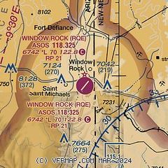
| Sectional chart |
|---|
|
| Airport distance calculator |
|---|
|
|
| Sunrise and sunset |
|---|
|
Times for 11-Apr-2025
| | Local
(UTC-6) | | Zulu
(UTC) |
|---|
| Morning civil twilight | | 06:24 | | 12:24 |
| Sunrise | | 06:50 | | 12:50 |
| Sunset | | 19:45 | | 01:45 |
| Evening civil twilight | | 20:11 | | 02:11 |
|
| Current date and time |
|---|
| Zulu (UTC) | 12-Apr-2025 01:32:02 |
|---|
| Local (UTC-6) | 11-Apr-2025 19:32:02 |
|---|
|
| METAR |
|---|
| KRQE | 120053Z AUTO 23006KT 10SM CLR 22/M02 A3019 RMK AO2 SLP155 T02221017
|
KGUP
15nm SE | 120053Z AUTO 24011KT 10SM CLR 24/M13 A3018 RMK AO2 SLP134 T02391128
|
|
| TAF |
|---|
KGUP
15nm SE | 111939Z 1120/1218 23012G19KT P6SM FEW250 FM120100 21007KT P6SM SCT250 FM120300 VRB03KT P6SM SKC
|
|
| NOTAMs |
|---|
NOTAMs are issued by the DoD/FAA and will open in a separate window not controlled by AirNav.
|
|


