FAA INFORMATION EFFECTIVE 30 OCTOBER 2025
Location
| FAA Identifier: | GUP |
| Lat/Long: | 35-30-39.8100N 108-47-21.5140W
35-30.663500N 108-47.358567W
35.5110583,-108.7893094
(estimated) |
| Elevation: | 6472.6 ft. / 1972.8 m (surveyed) |
| Variation: | 12E (1985) |
| From city: | 3 miles SW of GALLUP, NM |
| Time zone: | UTC -7 (UTC -6 during Daylight Saving Time) |
| Zip code: | 87301 |
Airport Operations
| Airport use: | Open to the public |
| Control tower: | no |
| ARTCC: | ALBUQUERQUE CENTER |
| FSS: | ALBUQUERQUE FLIGHT SERVICE STATION |
| NOTAMs facility: | GUP (NOTAM-D service available) |
| Attendance: | 0700-1900 |
| Wind indicator: | lighted |
| Segmented circle: | yes |
| Lights: | ACTVT REIL RWY 24; MIRL RWY 06/24 - CTAF. |
| Beacon: | white-green (lighted land airport)
Operates sunset to sunrise. |
Airport Communications
| CTAF/UNICOM: | 122.95 |
| WX ASOS: | 118.375 (505-726-8232) |
| WX ASOS at RQE (16 nm NW): | 118.325 (928-810-7235) |
- COMMUNICATIONS PRVDD BY ALBUQUERQUE RADIO ON FREQ 122.1R (GALLUP RCO).
- APCH/DEP SVC PRVDD BY ALBUQUERQUE ARTCC (ZAB) ON 124.325/288.25 (WEST MESA RCAG).
Nearby radio navigation aids
| VOR radial/distance | | VOR name | | Freq | | Var |
|---|
| GUPr049/4.6 | | GALLUP VORTAC | | 115.10 | | 14E |
| ZUNr015/37.3 | | ZUNI VORTAC | | 113.40 | | 14E |
Airport Services
| Fuel available: | 100LL JET-A1+ |
| Parking: | hangars and tiedowns |
Runway Information
Runway 6/24
| Dimensions: | 7312 x 100 ft. / 2229 x 30 m |
| Surface: | asphalt, in good condition |
| Weight bearing capacity: | | PCN 39 /F/C/X/T | | Single wheel: | 45.0 | | Double wheel: | 55.0 |
|
| Runway edge lights: | medium intensity |
| Operational restrictions: | RWY 24 CALM WIND RWY. |
| RUNWAY 6 | | RUNWAY 24 |
| Latitude: | 35-30.496260N | | 35-30.830683N |
| Longitude: | 108-48.066373W | | 108-46.650708W |
| Elevation: | 6464.6 ft. | | 6472.3 ft. |
| Traffic pattern: | left | | left |
| Runway heading: | 062 magnetic, 074 true | | 242 magnetic, 254 true |
| Markings: | nonprecision, in good condition | | nonprecision, in good condition |
| Visual slope indicator: | 2-light PAPI on left (3.00 degrees glide path) | | 2-light PAPI on left (3.00 degrees glide path) |
| Runway end identifier lights: | | | yes |
| Touchdown point: | yes, no lights | | yes, no lights |
| Instrument approach: | LOC/DME | | |
| Obstructions: | 34 ft. tree, 1325 ft. from runway, 50 ft. left of centerline, 33:1 slope to clear | | 35 ft. tree, 1375 ft. from runway, 200 ft. left of centerline, 33:1 slope to clear |
Airport Ownership and Management from official FAA records
| Ownership: | Publicly-owned |
| Owner: | CITY OF GALLUP
BOX 1270
GALLUP, NM 87305
Phone 505-863-1254 |
| Manager: | ROBERT HAMBLEN
110 WEST AZTEC
GALLUP, NM 87301
Phone 505-863-1290
EMERG - AARON LESLIE 505-870-2788. |
Additional Remarks
| - | FOR CD IF UNA TO CTC ON FSS FREQ, CTC ALBUQUERQUE ARTCC AT 505-856-4561. |
| - | SELF SVC FUEL H24 WITH CREDIT CARD. AFT HR FUEL CALL OUT FEE - 505-879-6222. |
Instrument Procedures
NOTE: All procedures below are presented as PDF files. If you need a reader for these files, you should download the free Adobe Reader.NOT FOR NAVIGATION. Please procure official charts for flight.
FAA instrument procedures published for use from 30 October 2025 at 0901Z to 27 November 2025 at 0900Z.
IAPs - Instrument Approach Procedures |
|---|
| RNAV (GPS) RWY 06 | |
download (227KB) |
| RNAV (GPS) RWY 24 | |
download (195KB) |
| LOC RWY 06 | |
download (209KB) |
| VOR RWY 06 | |
download (194KB) |
| NOTE: Special Alternate Minimums apply | |
download (144KB) |
| NOTE: Special Take-Off Minimums/Departure Procedures apply | |
download (105KB) |
Other nearby airports with instrument procedures:
KRQE - Window Rock Airport (16 nm NW)
KGNT - Grants-Milan Municipal Airport (48 nm SE)
KSJN - St Johns Industrial Air Park (66 nm SW)
KFMN - Four Corners Regional Airport (79 nm N)
KJTC - Springerville Municipal Airport (87 nm S)
|
|

Road maps at:
MapQuest
Bing
Google
| Aerial photo |
|---|
WARNING: Photo may not be current or correct
 Photo by Lee Morgan
Photo taken 18-Jun-2010
Photo by Lee Morgan
Photo taken 18-Jun-2010
Do you have a better or more recent aerial photo of Gallup Municipal Airport that you would like to share? If so, please send us your photo.
|
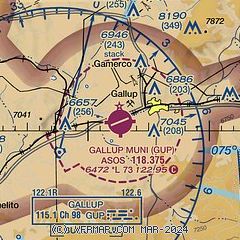
| Sectional chart |
|---|
|
| Airport distance calculator |
|---|
|
|
| Sunrise and sunset |
|---|
|
Times for 14-Nov-2025
| | Local
(UTC-7) | | Zulu
(UTC) |
|---|
| Morning civil twilight | | 06:24 | | 13:24 |
| Sunrise | | 06:51 | | 13:51 |
| Sunset | | 17:09 | | 00:09 |
| Evening civil twilight | | 17:36 | | 00:36 |
|
| Current date and time |
|---|
| Zulu (UTC) | 14-Nov-2025 08:33:39 |
|---|
| Local (UTC-7) | 14-Nov-2025 01:33:39 |
|---|
|
| METAR |
|---|
| KGUP | 140753Z AUTO 00000KT 10SM CLR M01/M09 A3028 RMK AO2 SLP189 T10061094
|
KRQE
16nm NW | 140753Z AUTO 00000KT 10SM CLR M01/M09 A3029 RMK AO2 SLP200 T10111089
|
|
| TAF |
|---|
| KGUP | 140520Z 1406/1506 VRB03KT P6SM SCT200 FM141900 23010G18KT P6SM SCT200 FM150100 VRB03KT P6SM FEW200
|
|
| NOTAMs |
|---|
NOTAMs are issued by the DoD/FAA and will open in a separate window not controlled by AirNav.
|
|


