FAA INFORMATION EFFECTIVE 27 NOVEMBER 2025
Location
| FAA Identifier: | T20 |
| Lat/Long: | 29-31-44.8450N 097-27-51.4900W
29-31.747417N 097-27.858167W
29.5291236,-97.4643028
(estimated) |
| Elevation: | 354 ft. / 107.9 m (surveyed) |
| Variation: | 07E (1985) |
| From city: | 2 miles NW of GONZALES, TX |
| Time zone: | UTC -6 (UTC -5 during Daylight Saving Time) |
| Zip code: | 78629 |
Airport Operations
| Airport use: | Open to the public |
| Activation date: | 11/1955 |
| Control tower: | no |
| ARTCC: | HOUSTON CENTER |
| FSS: | SAN ANGELO FLIGHT SERVICE STATION |
| NOTAMs facility: | T20 (NOTAM-D service available) |
| Attendance: | UNATNDD |
| Wind indicator: | lighted |
| Segmented circle: | yes |
| Lights: | MIRL RWY 15/33 PRESET ON LOW INTST; TO INCR INTST ACTVT - 123.0. |
| Beacon: | white-green (lighted land airport)
Operates sunset to sunrise. |
Airport Communications
| CTAF: | 122.9 |
| WX AWOS-3: | 125.875 (830-519-4254) |
Airport Services
| Fuel available: | 100LL
100LL:FUEL SELF-SERVE. |
| Parking: | tiedowns |
| Airframe service: | NONE |
| Powerplant service: | NONE |
| Bottled oxygen: | NONE |
| Bulk oxygen: | NONE |
Runway Information
Runway 15/33
| Dimensions: | 3200 x 50 ft. / 975 x 15 m |
| Surface: | asphalt, in fair condition |
| Weight bearing capacity: | |
| Runway edge lights: | medium intensity |
| RUNWAY 15 | | RUNWAY 33 |
| Latitude: | 29-31.988167N | | 29-31.506667N |
| Longitude: | 097-27.982333W | | 097-27.734000W |
| Elevation: | 342.4 ft. | | 351.8 ft. |
| Traffic pattern: | left | | right |
| Markings: | basic, in good condition | | basic, in good condition |
| Obstructions: | 13 ft. trees, 200 ft. from runway, 120 ft. right of centerline
22 FT TREES 59-199 DSTC, 120 FT R; +4 FT FENCE 120 FT R AT THR. | | 130 ft. tower, 2600 ft. from runway, 170 ft. left of centerline, 18:1 slope to clear
4 FT FENCE AT THR, 122 FT R. |
Airport Ownership and Management from official FAA records
| Ownership: | Publicly-owned |
| Owner: | CITY OF GONZALES
PO BOX 547
GONZALES, TX 78629
Phone 830-672-2815 |
| Manager: | RALPH CAMARILLO
820 ST. JOSEPH ST
GONZALES, TX 78629
Phone 830-672-2815
830-263-2145 MGR CELL. |
Additional Remarks
| - | RWY 33 5 FT HILL, 80 FT R & L OF CNTRLN FROM THR NORTH 500 FT. |
| - | FOR CD CTC AUSTIN APCH AT 512-369-7865. |
| - | RWY 33, 100 FT ELEC TRANSMISSION LINE ACRS S APCH, 2400 FT DSTC, MKD & LGTD. |
Instrument Procedures
There are no published instrument procedures at T20.
Some nearby airports with instrument procedures:
T85 - Yoakum Municipal Airport (21 nm SE)
50R - Lockhart Municipal Airport (22 nm NW)
KHYI - San Marcos Regional Airport (30 nm NW)
KBAZ - New Braunfels National Airport (32 nm W)
84R - Smithville Crawford Municipal Airport (34 nm NE)
|
|

Road maps at:
MapQuest
Bing
Google
| Aerial photo |
|---|
WARNING: Photo may not be current or correct
 Photo by Al ODonnell
Photo taken 05-Nov-2011
looking northwest.
Photo by Al ODonnell
Photo taken 05-Nov-2011
looking northwest.
Do you have a better or more recent aerial photo of Roger M Dreyer Memorial Airport that you would like to share? If so, please send us your photo.
|
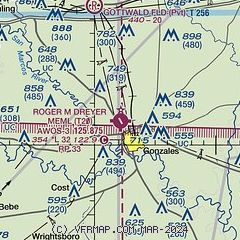
| Sectional chart |
|---|
|
| Airport distance calculator |
|---|
|
|
| Sunrise and sunset |
|---|
|
Times for 07-Dec-2025
| | Local
(UTC-6) | | Zulu
(UTC) |
|---|
| Morning civil twilight | | 06:47 | | 12:47 |
| Sunrise | | 07:13 | | 13:13 |
| Sunset | | 17:30 | | 23:30 |
| Evening civil twilight | | 17:56 | | 23:56 |
|
| Current date and time |
|---|
| Zulu (UTC) | 07-Dec-2025 09:14:12 |
|---|
| Local (UTC-6) | 07-Dec-2025 03:14:12 |
|---|
|
| METAR |
|---|
| KT20 | 070855Z AUTO 22003KT 1/2SM FG OVC002 15/15 A2989 RMK AO2 T01460145
|
|
| NOTAMs |
|---|
NOTAMs are issued by the DoD/FAA and will open in a separate window not controlled by AirNav.
|
|

