FAA INFORMATION EFFECTIVE 15 MAY 2025
Location
| FAA Identifier: | TCC |
| Lat/Long: | 35-10-58.0010N 103-36-11.5000W
35-10.966683N 103-36.191667W
35.1827781,-103.6031944
(estimated) |
| Elevation: | 4064.9 ft. / 1239.0 m (surveyed) |
| Variation: | 12E (1965) |
| From city: | 6 miles E of TUCUMCARI, NM |
| Time zone: | UTC -6 (UTC -7 during Standard Time) |
| Zip code: | 88401 |
Airport Operations
| Airport use: | Open to the public |
| Activation date: | 08/1941 |
| Control tower: | no |
| ARTCC: | ALBUQUERQUE CENTER |
| FSS: | ALBUQUERQUE FLIGHT SERVICE STATION |
| NOTAMs facility: | TCC (NOTAM-D service available) |
| Attendance: | 0700-1700
CLSD FED HOL. |
| Wind indicator: | lighted |
| Segmented circle: | yes |
| Lights: | ACTVT VASI RWY 21; MIRL RWY 03/21 & 08/26 - CTAF. |
| Beacon: | white-green (lighted land airport)
Operates sunset to sunrise. |
Airport Communications
| CTAF/UNICOM: | 122.95 |
| WX ASOS: | 119.275 (575-461-4940) |
- APCH/DEP SVC PRVDD BY ALBUQUERQUE ARTCC (ZAB) ON FREQS 126.85/285.6 (TUCUMCARI RCAG).
Nearby radio navigation aids
| VOR radial/distance | | VOR name | | Freq | | Var |
|---|
| TCC at field | | TUCUMCARI VORTAC | | 113.60 | | 12E |
Airport Services
| Fuel available: | 100LL JET-A+ |
| Parking: | hangars and tiedowns |
Runway Information
Runway 3/21
| Dimensions: | 7104 x 100 ft. / 2165 x 30 m |
| Surface: | asphalt, in good condition |
| Weight bearing capacity: | | PCN 10 /F/C/Y/T | | Single wheel: | 25.0 |
|
| Runway edge lights: | medium intensity |
| RUNWAY 3 | | RUNWAY 21 |
| Latitude: | 35-10.492647N | | 35-11.319925N |
| Longitude: | 103-36.669328W | | 103-35.660220W |
| Elevation: | 4039.7 ft. | | 4047.0 ft. |
| Traffic pattern: | left | | left |
| Runway heading: | 033 magnetic, 045 true | | 213 magnetic, 225 true |
| Markings: | nonprecision, in poor condition | | nonprecision, in poor condition |
| Visual slope indicator: | | | 4-box VASI on left (3.00 degrees glide path) |
| Touchdown point: | yes, no lights | | yes, no lights |
Runway 8/26
| Dimensions: | 4600 x 60 ft. / 1402 x 18 m |
| Surface: | asphalt, in good condition |
| Weight bearing capacity: | | PCN 6 /F/D/Y/T | | Single wheel: | 12.0 |
|
| Runway edge lights: | medium intensity |
| RUNWAY 8 | | RUNWAY 26 |
| Latitude: | 35-11.059317N | | 35-11.058803N |
| Longitude: | 103-36.695837W | | 103-35.772388W |
| Elevation: | 4064.9 ft. | | 4036.0 ft. |
| Traffic pattern: | left | | left |
| Runway heading: | 078 magnetic, 090 true | | 258 magnetic, 270 true |
| Markings: | nonprecision, in fair condition | | nonprecision, in fair condition |
| Touchdown point: | yes, no lights | | yes, no lights |
Airport Ownership and Management from official FAA records
| Ownership: | Publicly-owned |
| Owner: | CITY OF TUCUMCARI
BOX 1188
TUCUMCARI, NM 88401
Phone 575-461-3451 |
| Manager: | JIM SEWELL
6352 QRA1 ROAD
TUCUMCARI, NM 88401
Phone 575-461-3229
EMERG - 575-461-2280. |
Additional Remarks
| - | FOR CD IF UNA TO CTC ON FSS FREQ, CTC ALBUQUERQUE ARTCC AT 505-856-4561. |
| - | AFT HR FUEL SELF SVC WITH CREDIT CARD. |
Instrument Procedures
NOTE: All procedures below are presented as PDF files. If you need a reader for these files, you should download the free Adobe Reader.NOT FOR NAVIGATION. Please procure official charts for flight.
FAA instrument procedures published for use from 15 May 2025 at 0901Z to 13 June 2025 at 0900z.
IAPs - Instrument Approach Procedures |
|---|
| RNAV (GPS) RWY 03 | |
download (173KB) |
| RNAV (GPS) RWY 21 | |
download (197KB) |
| RNAV (GPS) RWY 26 | |
download (195KB) |
| VOR RWY 21 | |
download (196KB) |
| NOTE: Special Take-Off Minimums/Departure Procedures apply | |
download (105KB) |
Other nearby airports with instrument procedures:
KCVS - Cannon Air Force Base (50 nm S)
KCVN - Clovis Regional Airport (52 nm SE)
KPRZ - Portales Municipal Airport (63 nm S)
KHRX - Hereford Municipal Airport (66 nm E)
KDHT - Dalhart Municipal Airport (72 nm NE)
|
|

Road maps at:
MapQuest
Bing
Google
| Aerial photo |
|---|
WARNING: Photo may not be current or correct
 Photo by Frank Ayres
Photo taken 25-Jan-2009
Photo by Frank Ayres
Photo taken 25-Jan-2009
Do you have a better or more recent aerial photo of Tucumcari Municipal Airport that you would like to share? If so, please send us your photo.
|
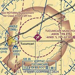
| Sectional chart |
|---|
|
| Airport distance calculator |
|---|
|
|
| Sunrise and sunset |
|---|
|
Times for 25-May-2025
| | Local
(UTC-6) | | Zulu
(UTC) |
|---|
| Morning civil twilight | | 05:16 | | 11:16 |
| Sunrise | | 05:45 | | 11:45 |
| Sunset | | 19:58 | | 01:58 |
| Evening civil twilight | | 20:27 | | 02:27 |
|
| Current date and time |
|---|
| Zulu (UTC) | 25-May-2025 12:59:14 |
|---|
| Local (UTC-6) | 25-May-2025 06:59:14 |
|---|
|
| METAR |
|---|
| KTCC | 251253Z AUTO 35009KT 10SM BKN011 BKN026 OVC030 17/16 A3001 RMK AO2 SLP102 T01670161
|
|
| TAF |
|---|
| KTCC | 251120Z 2512/2612 02008KT 6SM BR SCT009 TEMPO 2512/2515 BKN009 FM251700 05011KT P6SM SCT020 BKN150 FM251900 05014G22KT P6SM FEW020 BKN150 FM252100 07013G21KT 6SM -SHRA BKN040 PROB30 2521/2601 VRB22G32KT -TSRA BKN040CB FM260200 05017G25KT P6SM OVC020 FM260600 04013G21KT 6SM BR OVC015
|
|
| NOTAMs |
|---|
NOTAMs are issued by the DoD/FAA and will open in a separate window not controlled by AirNav.
|
|


