FAA INFORMATION EFFECTIVE 22 JANUARY 2026
Location
| FAA Identifier: | TS07 |
| Lat/Long: | 29-59-10.3800N 095-41-08.3850W
29-59.173000N 095-41.139750W
29.9862167,-95.6856625
(estimated) |
| Elevation: | 152.4 ft. / 46 m (estimated) |
| Variation: | 04E (2010) |
| From city: | 1 mile NE of CYPRESS, TX |
| Time zone: | UTC -6 (UTC -5 during Daylight Saving Time) |
| Zip code: | 77429 |
Airport Operations
| Airport use: | Private use. Permission required prior to landing |
| Activation date: | 03/1971 |
| Control tower: | no |
| ARTCC: | HOUSTON CENTER |
| FSS: | MONTGOMERY COUNTY FLIGHT SERVICE STATION |
| NOTAMs facility: | FDC (NOTAM-D service not available) |
| Attendance: | IREG |
| Wind indicator: | lighted |
| Segmented circle: | no |
| Lights: | RWY 18 & 36 PAPI; MIRL RWY 18/36 OPR DUSK TO 2300 LCL SUN-THU, DUSK TO 2359 LCL FRI-SAT. ALL OTR TIMES ACTVT - CTAF. |
| Beacon: | white-green (lighted land airport)
DUSK TO 2300 LCL SUN-THU, DUSK TO 2359 LCL FRI-SAT. ALL OTR TIMES ACTVT - CTAF. |
Airport Communications
| CTAF: | 122.9 |
| WX ASOS at DWH (8 nm NE): | 128.375 (281-251-7853) |
| WX AWOS-3 at TME (15 nm SW): | 119.525 (281-574-7296) |
| WX ASOS at IAH (18 nm E): | PHONE 713-338-9561 |
Nearby radio navigation aids
| VOR radial/distance | | VOR name | | Freq | | Var |
|---|
| IAHr271/17.8 | | HUMBLE VORTAC | | 116.60 | | 05E |
| TNVr125/26.5 | | NAVASOTA VOR/DME | | 115.90 | | 08E |
Airport Services
| Parking: | hangars and tiedowns |
| Airframe service: | MAJOR |
| Powerplant service: | MAJOR |
Runway Information
Runway 18/36
| Dimensions: | 3580 x 73 ft. / 1091 x 22 m |
| Surface: | turf, in good condition |
| Runway edge lights: | medium intensity |
| Runway edge markings: | MKD WITH EMBEDDED WHITE CONC MKRS AT RWY THR AND DSPLCD THR. |
| RUNWAY 18 | | RUNWAY 36 |
| Latitude: | 29-59.468333N | | 29-58.877667N |
| Longitude: | 095-41.147500W | | 095-41.132000W |
| Elevation: | 152.2 ft. | | 147.4 ft. |
| Traffic pattern: | left | | left |
| Runway heading: | 175 magnetic, 179 true | | 355 magnetic, 359 true |
| Displaced threshold: | 450 ft. | | 595 ft. |
| Markings: | NSTD, in good condition | | NSTD, in good condition |
| Visual slope indicator: | 2-light PAPI on left (5.05 degrees glide path) | | 2-light PAPI on right (4.00 degrees glide path) |
| Touchdown point: | yes, no lights | | yes, no lights |
| Obstructions: | 42 ft. pole, marked, 416 ft. from runway, 55 ft. left of centerline, 9:1 slope to clear | | 66 ft. tree, 617 ft. from runway, 115 ft. left of centerline, 9:1 slope to clear |
Airport Ownership and Management from official FAA records
| Ownership: | Privately-owned |
| Owner: | SKINNER ROAD ARPT COMMUNITY HOA
14425 DRY CREEK DR
CYPRESS, TX 77429
Phone (832) 349-8236 |
| Manager: | TOM BUSH
14403 DRY CREEK DR
CYPRESS, TX 77429
Phone (832) 349-8236
JEETER131@ME.COM |
Additional Remarks
| - | FOR CD CTC HOUSTON ARTCC AT 281-230-5622. |
Instrument Procedures
There are no published instrument procedures at TS07.
Some nearby airports with instrument procedures:
KDWH - David Wayne Hooks Memorial Airport (8 nm NE)
KIWS - West Houston Airport (10 nm S)
KTME - Houston Executive Airport (15 nm SW)
KIAH - George Bush Intercontinental/Houston Airport (18 nm E)
KSGR - Sugar Land Regional Airport (22 nm S)
|
|

Road maps at:
MapQuest
Bing
Google
| Aerial photo |
|---|
WARNING: Photo may not be current or correct

Do you have a better or more recent aerial photo of Dry Creek Airport that you would like to share? If so, please send us your photo.
|
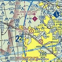
| Sectional chart |
|---|
|
| Airport distance calculator |
|---|
|
|
| Sunrise and sunset |
|---|
|
Times for 18-Feb-2026
| | Local
(UTC-6) | | Zulu
(UTC) |
|---|
| Morning civil twilight | | 06:37 | | 12:37 |
| Sunrise | | 07:01 | | 13:01 |
| Sunset | | 18:13 | | 00:13 |
| Evening civil twilight | | 18:37 | | 00:37 |
|
| Current date and time |
|---|
| Zulu (UTC) | 19-Feb-2026 03:05:10 |
|---|
| Local (UTC-6) | 18-Feb-2026 21:05:10 |
|---|
|
| METAR |
|---|
KDWH
9nm NE | 190253Z 18005KT 10SM OVC040 22/17 A2975 RMK AO2 SLP073 T02170172 55002
|
KTME
15nm SW | 190255Z AUTO 19007KT 8SM OVC021 20/19 A2977 RMK AO2
|
KIAH
17nm E | 190253Z 17007KT 10SM FEW026 OVC037 22/18 A2977 RMK AO2 SLP079 T02220183 53004
|
|
| TAF |
|---|
KIAH
17nm E | 182055Z 1821/1924 18012KT P6SM BKN040 FM190700 18009KT P6SM SCT007 BKN010 TEMPO 1908/1911 BKN007 FM191500 19008KT P6SM BKN020 FM191700 21008KT P6SM SCT025 BKN035
|
|
| NOTAMs |
|---|
NOTAMs are issued by the DoD/FAA and will open in a separate window not controlled by AirNav.
|
|

