FAA INFORMATION EFFECTIVE 15 MAY 2025
Location
| FAA Identifier: | TT97 |
| Lat/Long: | 32-57-16.3920N 102-32-27.2350W
32-57.273200N 102-32.453917W
32.9545533,-102.5408986
(estimated) |
| Elevation: | 3366 ft. / 1026 m (estimated) |
| Variation: | 09E (1985) |
| From city: | 1 mile NE of SEAGRAVES, TX |
| Time zone: | UTC -5 (UTC -6 during Standard Time) |
| Zip code: | 79359 |
Airport Operations
| Airport use: | Private use. Permission required prior to landing |
| Control tower: | no |
| ARTCC: | FORT WORTH CENTER |
| FSS: | FORT WORTH FLIGHT SERVICE STATION |
| Attendance: | UNATNDD |
| Wind indicator: | yes |
| Segmented circle: | no |
| Lights: | SS-SR |
Airport Communications
| CTAF: | 122.9 |
| WX AWOS-3PT at E57 (15 nm W): | 118.275 (806-592-3681) |
| WX AWOS-3 at GNC (18 nm S): | 118.075 (432-758-3102) |
Airport Services
| Parking: | tiedowns |
| Airframe service: | NONE |
| Powerplant service: | NONE |
| Bottled oxygen: | NONE |
| Bulk oxygen: | NONE |
Runway Information
Runway 4/22
| Dimensions: | 4010 x 70 ft. / 1222 x 21 m |
| Surface: | asphalt, in fair condition |
| Runway edge lights: | non-standard
LIRL NSTD FOR SPACING. |
| RUNWAY 4 | | RUNWAY 22 |
| Traffic pattern: | left | | left |
| Obstructions: | 23 ft. rr, 201 ft. from runway, 57 ft. left of centerline
RAILROAD 57 FT LEFT AT THR, 7 FT BERM 50 FT LEFT AT THR. | | 23 ft. rr, 201 ft. from runway, 112 ft. right of centerline
RAILROAD 112 FT RIGHT AT THR; 17 FT RD 0 FT DSTC, 86 FT R; 24 FT RAILROAD SGL, 100 FT DSTC, 80 FT R. |
Runway 17/35
| Dimensions: | 2445 x 37 ft. / 745 x 11 m |
| Surface: | asphalt, in fair condition |
| RUNWAY 17 | | RUNWAY 35 |
| Traffic pattern: | left | | left |
| Obstructions: | 20 ft. road, 201 ft. from runway
4 FT BERM 39 FT DSTC, 0B; 35 FT POLES 110 FT DSTC, 105 FT L, 15 FT RD 45 FT LEFT AT THR. | | 15 ft. road, 201 ft. from runway, 55 ft. right of centerline
ROAD 55 FT RIGHT AT THR; 10 FT ROAD 10 FT FM THR 0B, 5 FT METAL FENCE POST 35 FT FM THR OB; 5 FT METAL FENCE POST 35 FT FM THR TO 200 FT FM THR 32 FT RIGHT. |
Airport Ownership and Management from official FAA records
| Ownership: | Privately-owned |
| Owner: | GAINES CO., TX
P.O. BOX 847
SEMINOLE, TX 79359
Phone 432-758-5411
RWYS OWNED & MNTND BY GAINES CO. ADJ PROPERTY & HNGRS OWNED BY SEAGRAVES SPRAYING 361-648-2272, AGAERO2@CROSWIND.NET |
| Manager: | BRIAN ROSSON
P.O. BOX 847
SEAGRAVES, TX 79360
Phone 432-758-5411 |
Additional Remarks
| - | RWYS UNMKD. |
| - | FOR CD CTC FORT WORTH ARTCC AT 817-858-7584. |
Instrument Procedures
There are no published instrument procedures at TT97.
Some nearby airports with instrument procedures:
KGNC - Gaines County Airport (18 nm S)
F98 - Yoakum County Airport (21 nm NW)
KBFE - Terry County Airport (22 nm NE)
KLUV - Lamesa Municipal Airport (33 nm E)
KLLN - Levelland Municipal Airport (37 nm N)
|
|

Road maps at:
MapQuest
Bing
Google
| Aerial photo |
|---|

|
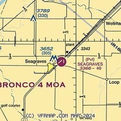
| Sectional chart |
|---|
|
| Airport distance calculator |
|---|
|
|
| Sunrise and sunset |
|---|
|
Times for 28-May-2025
| | Local
(UTC-5) | | Zulu
(UTC) |
|---|
| Morning civil twilight | | 06:17 | | 11:17 |
| Sunrise | | 06:45 | | 11:45 |
| Sunset | | 20:50 | | 01:50 |
| Evening civil twilight | | 21:18 | | 02:18 |
|
| Current date and time |
|---|
| Zulu (UTC) | 28-May-2025 11:41:59 |
|---|
| Local (UTC-5) | 28-May-2025 06:41:59 |
|---|
|
| METAR |
|---|
KGNC
18nm S | 281115Z AUTO 18006KT 10SM -DZ SCT001 SCT009 15/13 A3021 RMK AO2 T01530133
|
KLUV
33nm E | 281115Z AUTO 04010KT 10SM CLR 16/14 A3015 RMK AO2 LTG DSNT NE P0001
|
|
| TAF |
|---|
KHOB
38nm SW | 280933Z 2810/2906 34014G20KT P6SM SCT045 BKN070 FM281100 10009KT P6SM OVC250 FM281600 16011KT P6SM SCT045 SCT250 FM290200 27011KT P6SM FEW200
|
|
| NOTAMs |
|---|
NOTAMs are issued by the DoD/FAA and will open in a separate window not controlled by AirNav.
|
|


