FAA INFORMATION EFFECTIVE 19 FEBRUARY 2026
Location
| FAA Identifier: | LUV |
| Lat/Long: | 32-45-22.7000N 101-55-12.8000W
32-45.378333N 101-55.213333W
32.7563056,-101.9202222
(estimated) |
| Elevation: | 2998.6 ft. / 914.0 m (surveyed) |
| Variation: | 06E (2020) |
| From city: | 2 miles NE of LAMESA, TX |
| Time zone: | UTC -6 (UTC -5 during Daylight Saving Time) |
| Zip code: | 79331 |
Airport Operations
| Airport use: | Open to the public |
| Activation date: | 05/1971 |
| Control tower: | no |
| ARTCC: | FORT WORTH CENTER |
| FSS: | FORT WORTH FLIGHT SERVICE STATION |
| NOTAMs facility: | FTW (NOTAM-D service available) |
| Attendance: | UNATNDD |
| Wind indicator: | lighted |
| Segmented circle: | yes |
| Lights: | SS-SR |
| Beacon: | white-green (lighted land airport)
Operates sunset to sunrise. |
Airport Communications
| CTAF/UNICOM: | 122.8 |
| WX AWOS-3PT: | 124.175 (806-872-0659) |
- APCH/DEP CTL SVC PRVDD BY FORT WORTH ARTCC (ZFW) ON FREQS 132.6/269.05 (LUBBOCK RCAG).
Nearby radio navigation aids
| VOR radial/distance | | VOR name | | Freq | | Var |
|---|
| BGSr304/31.3 | | BIG SPRING VORTAC | | 117.20 | | 11E |
Airport Services
| Fuel available: | 100LL JET-A1+
A1+:FOR FUEL SVC 806-759-9270, 806-759-7747 OR 806-759-7250. |
| Parking: | tiedowns |
| Airframe service: | MAJOR |
| Powerplant service: | MAJOR
ACFT MAINT 806-200-5108. |
Runway Information
Runway 16/34
| Dimensions: | 5002 x 75 ft. / 1525 x 23 m |
| Surface: | asphalt, in good condition |
| Weight bearing capacity: | |
| Runway edge lights: | medium intensity |
| RUNWAY 16 | | RUNWAY 34 |
| Latitude: | 32-45.629155N | | 32-44.831212N |
| Longitude: | 101-55.097582W | | 101-54.850600W |
| Elevation: | 2991.7 ft. | | 2985.5 ft. |
| Traffic pattern: | left | | left |
| Runway heading: | 159 magnetic, 165 true | | 339 magnetic, 345 true |
| Markings: | nonprecision, in good condition | | nonprecision, in good condition |
| Visual slope indicator: | 2-light PAPI on left (3.00 degrees glide path) | | 2-light PAPI on left (3.00 degrees glide path) |
| Touchdown point: | yes, no lights | | yes, no lights |
| Obstructions: | 12 ft. road, 530 ft. from runway, 27:1 slope to clear | | none |
Runway 7/25
| Dimensions: | 4006 x 60 ft. / 1221 x 18 m |
| Surface: | asphalt, in excellent condition |
| Weight bearing capacity: | |
| Runway edge lights: | medium intensity |
| RUNWAY 7 | | RUNWAY 25 |
| Latitude: | 32-45.479747N | | 32-45.645295N |
| Longitude: | 101-55.891378W | | 101-55.134638W |
| Elevation: | 2991.7 ft. | | 2991.3 ft. |
| Traffic pattern: | left | | left |
| Runway heading: | 069 magnetic, 075 true | | 249 magnetic, 255 true |
| Markings: | basic, in good condition | | basic, in good condition |
| Visual slope indicator: | 2-light PAPI on left (3.00 degrees glide path) | | 2-light PAPI on left (3.00 degrees glide path) |
| Touchdown point: | yes, no lights | | yes, no lights |
| Obstructions: | 35 ft. tree, 1515 ft. from runway, 139 ft. left of centerline, 37:1 slope to clear | | 15 ft. road, 721 ft. from runway, 34:1 slope to clear |
Airport Ownership and Management from official FAA records
| Ownership: | Publicly-owned |
| Owner: | LAMESA CITY & DAWSON CO
601 S. 1ST
LAMESA, TX 79331
Phone 806-872-4321 |
| Manager: | JOHN FARRIS
P.O. BOX 259
LAMESA, TX 79331
Phone 806-759-7747 |
Additional Remarks
| - | FOR CD CTC FORT WORTH ARTCC AT 817-858-7584. |
| - | TWO COURTESY CARS AVBL. |
| - | RWY 7/25, DUE TO GRADE, ACFT ON RWY END NOT VSB FM OPPOSITE END. |
Instrument Procedures
NOTE: All procedures below are presented as PDF files. If you need a reader for these files, you should download the free Adobe Reader.NOT FOR NAVIGATION. Please procure official charts for flight.
FAA instrument procedures published for use from 19 February 2026 at 0901Z to 19 March 2026 at 0900Z.
IAPs - Instrument Approach Procedures |
|---|
| RNAV (GPS) RWY 16 | |
download (205KB) |
| RNAV (GPS) RWY 34 | |
download (219KB) |
| NOTE: Special Alternate Minimums apply | |
download (36KB) |
| NOTE: Special Take-Off Minimums/Departure Procedures apply | |
download (301KB) |
Other nearby airports with instrument procedures:
KBFE - Terry County Airport (29 nm NW)
KGNC - Gaines County Airport (37 nm W)
KBPG - Big Spring/Mc Mahon-Wrinkle Airport (38 nm SE)
E11 - Andrews County Airport (40 nm SW)
F82 - Lubbock Executive Airpark (44 nm N)
|
|

Road maps at:
MapQuest
Bing
Google
| Aerial photo |
|---|
WARNING: Photo may not be current or correct
 Photo taken 03-May-2007
Do you have a better or more recent aerial photo of Lamesa Municipal Airport that you would like to share? If so, please send us your photo.
|
| Sectional chart |
|---|
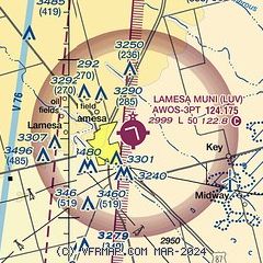
|
CAUTION: Diagram may not be current

| Airport distance calculator |
|---|
|
|
| Sunrise and sunset |
|---|
|
Times for 08-Mar-2026
| | Local
(UTC-6) | | Zulu
(UTC) |
|---|
| Morning civil twilight | | 06:43 | | 12:43 |
| Sunrise | | 07:08 | | 13:08 |
| Sunset | | 18:49 | | 00:49 |
| Evening civil twilight | | 19:14 | | 01:14 |
|
| Current date and time |
|---|
| Zulu (UTC) | 08-Mar-2026 06:38:29 |
|---|
| Local (UTC-6) | 08-Mar-2026 00:38:29 |
|---|
|
| METAR |
|---|
| KLUV | 080615Z AUTO 09003KT 10SM SCT055 07/M03 A3016 RMK AO2
|
|
| NOTAMs |
|---|
NOTAMs are issued by the DoD/FAA and will open in a separate window not controlled by AirNav.
|
|


