FAA INFORMATION EFFECTIVE 16 APRIL 2026
Location
| FAA Identifier: | BPG |
| Lat/Long: | 32-12-45.4240N 101-31-17.9270W
32-12.757067N 101-31.298783W
32.2126178,-101.5216464
(estimated) |
| Elevation: | 2572.8 ft. / 784.2 m (surveyed) |
| Variation: | 07E (2010) |
| From city: | 2 miles SW of BIG SPRING, TX |
| Time zone: | UTC -5 (UTC -6 during Standard Time) |
| Zip code: | 79720 |
Airport Operations
| Airport use: | Open to the public |
| Control tower: | no |
| ARTCC: | FORT WORTH CENTER |
| FSS: | SAN ANGELO FLIGHT SERVICE STATION |
| NOTAMs facility: | BPG (NOTAM-D service available) |
| Attendance: | MON-FRI 0800-1700 |
| Wind indicator: | lighted |
| Segmented circle: | yes |
| Lights: | MIRL RWYS 06/24 & 17/35 PRESET LOW INTST; TO INCR INTST & ACTVT SSALS RWY 17 - CTAF. |
| Beacon: | white-green (lighted land airport)
Operates sunset to sunrise. |
Airport Communications
| CTAF/UNICOM: | 122.8 |
| WX AWOS-3PT: | 118.025 (432-264-7475) |
- APCH/DEP CTL SVC PRVDD BY FORT WORTH ARTCC (ZFW) ON FREQS 133.7/350.2 (BIG SPRING RCAG).
Nearby radio navigation aids
| VOR radial/distance | | VOR name | | Freq | | Var |
|---|
| BGSr180/10.6 | | BIG SPRING VORTAC | | 117.20 | | 11E |
| MAFr059/36.1 | | MIDLAND VORTAC | | 112.60 | | 11E |
Airport Services
| Fuel available: | 100LL JET-A |
| Parking: | hangars and tiedowns |
| Airframe service: | MAJOR |
| Powerplant service: | MAJOR |
Runway Information
Runway 17/35
| Dimensions: | 8803 x 100 ft. / 2683 x 30 m |
| Surface: | concrete, in fair condition |
| Weight bearing capacity: | | Single wheel: | 60.0 | | Double wheel: | 150.0 | | Double tandem: | 200.0 |
|
| Runway edge lights: | medium intensity |
| RUNWAY 17 | | RUNWAY 35 |
| Latitude: | 32-13.609337N | | 32-12.158537N |
| Longitude: | 101-31.251737W | | 101-31.307907W |
| Elevation: | 2549.9 ft. | | 2561.8 ft. |
| Traffic pattern: | right | | left |
| Runway heading: | 175 magnetic, 182 true | | 355 magnetic, 002 true |
| Markings: | nonprecision, in fair condition | | nonprecision, in fair condition |
| Visual slope indicator: | 4-light PAPI on left (3.00 degrees glide path) | | 4-light PAPI on left (3.00 degrees glide path) |
| Approach lights: | SSALS: simplified short approach lighting system | | |
| Touchdown point: | yes, no lights | | yes, no lights |
Runway 6/24
| Dimensions: | 4601 x 75 ft. / 1402 x 23 m |
| Surface: | asphalt, in fair condition |
| Runway edge lights: | medium intensity |
| RUNWAY 6 | | RUNWAY 24 |
| Latitude: | 32-12.365392N | | 32-12.663277N |
| Longitude: | 101-31.745382W | | 101-30.924665W |
| Elevation: | 2547.0 ft. | | 2572.8 ft. |
| Traffic pattern: | right | | left |
| Runway heading: | 060 magnetic, 067 true | | 240 magnetic, 247 true |
| Markings: | nonprecision, in fair condition | | nonprecision, in fair condition |
| Visual slope indicator: | 2-light PAPI on left (3.00 degrees glide path) | | 2-light PAPI on left (3.00 degrees glide path) |
| Touchdown point: | yes, no lights | | yes, no lights |
| Obstructions: | none | | 5 ft. fence, 200 ft. from runway, 332 ft. left of centerline |
Airport Ownership and Management from official FAA records
| Ownership: | Publicly-owned |
| Owner: | CITY OF BIG SPRING
310 NOLAN
BIG SPRING, TX 79720
Phone 432-264-2400 |
| Manager: | MICHAEL FEELEY
3200 RICKABAUGH DRIVE WEST
BIG SPRING, TX 79720
Phone 432-264-2362
MGR CELL 432-466-3385. |
Additional Remarks
| - | FBO 432-264-7124. AFT HRS 432-935-1238. |
| - | SANDHILL CRANES XNG IN THE SPRING & FALL. |
| - | PRAIRIE DOGS ON RWYS & TWYS. |
| - | FOR CD CTC FORT WORTH ARTCC AT 817-858-7584. |
| - | 100 LL & JET-A FULL & SELF SERVE. |
Instrument Procedures
NOTE: All procedures below are presented as PDF files. If you need a reader for these files, you should download the free Adobe Reader.NOT FOR NAVIGATION. Please procure official charts for flight.
FAA instrument procedures published for use from 16 April 2026 at 0901Z to 14 May 2026 at 0900Z.
IAPs - Instrument Approach Procedures |
|---|
| RNAV (GPS) RWY 06 | |
download (257KB) |
| RNAV (GPS) RWY 17 | |
download (245KB) |
| RNAV (GPS) RWY 24 | |
download (264KB) |
| RNAV (GPS) RWY 35 | |
download (239KB) |
| VOR/DME RWY 17 | |
download (270KB) |
| VOR/DME RWY 35 | |
download (223KB) |
| NOTE: Special Alternate Minimums apply | |
download (138KB) |
| NOTE: Special Take-Off Minimums/Departure Procedures apply | |
download (299KB) |
Other nearby airports with instrument procedures:
KMDD - Midland Airpark (31 nm W)
KMAF - Midland International Air and Space Port Airport (38 nm SW)
KLUV - Lamesa Municipal Airport (38 nm NW)
KSNK - Winston Field Airport (41 nm NE)
KODO - Odessa Airport-Schlemeyer Field (47 nm W)
|
|

Road maps at:
MapQuest
Bing
Google
| Aerial photo |
|---|
WARNING: Photo may not be current or correct
 Photo by Marc Marchesseault
Photo taken 23-Jun-2009
Looking Northeast
Photo by Marc Marchesseault
Photo taken 23-Jun-2009
Looking Northeast
Do you have a better or more recent aerial photo of Big Spring/Mc Mahon-Wrinkle Airport that you would like to share? If so, please send us your photo.
|
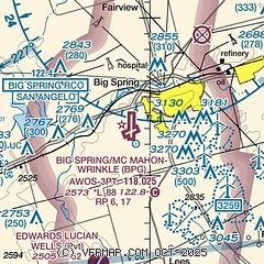
| Sectional chart |
|---|
|
| Airport distance calculator |
|---|
|
|
| Sunrise and sunset |
|---|
|
Times for 25-Apr-2026
| | Local
(UTC-5) | | Zulu
(UTC) |
|---|
| Morning civil twilight | | 06:41 | | 11:41 |
| Sunrise | | 07:07 | | 12:07 |
| Sunset | | 20:21 | | 01:21 |
| Evening civil twilight | | 20:47 | | 01:47 |
|
| Current date and time |
|---|
| Zulu (UTC) | 26-Apr-2026 02:40:46 |
|---|
| Local (UTC-5) | 25-Apr-2026 21:40:46 |
|---|
|
| METAR |
|---|
| KBPG | 260215Z AUTO 23010KT 10SM CLR 26/M06 A2970 RMK AO2 T02621055
|
|
| TAF |
|---|
KMAF
38nm SW | 251720Z 2518/2618 27016G22KT P6SM SKC FM260200 25010KT P6SM FEW200 FM261600 25016G22KT P6SM SKC
|
|
| NOTAMs |
|---|
NOTAMs are issued by the DoD/FAA and will open in a separate window not controlled by AirNav.
|
|


