FAA INFORMATION EFFECTIVE 09 JULY 2026
Location
| FAA Identifier: | SNK |
| Lat/Long: | 32-41-36.2000N 100-57-01.7000W
32-41.603333N 100-57.028333W
32.6933889,-100.9504722
(estimated) |
| Elevation: | 2430.3 ft. / 740.8 m (surveyed) |
| Variation: | 08E (1990) |
| From city: | 2 miles SW of SNYDER, TX |
| Time zone: | UTC -5 (UTC -6 during Standard Time) |
| Zip code: | 79549 |
Airport Operations
| Airport use: | Open to the public |
| Activation date: | 07/1950 |
| Control tower: | no |
| ARTCC: | FORT WORTH CENTER |
| FSS: | FORT WORTH FLIGHT SERVICE STATION |
| NOTAMs facility: | SNK (NOTAM-D service available) |
| Attendance: | 0800-1800
ARPT UNATNDD THANKSGIVING, CHRISTMAS, AND EASTER. FOR ATNDT AFT HRS CALL 325-573-3551, CALL-IN FEE. |
| Wind indicator: | lighted |
| Segmented circle: | yes |
| Lights: | DUSK-DAWN. MIRL RWY 17/35 PRESET LOW INTST; TO INCR INTST & ACTVT PAPI RWYS 17 & 35 - CTAF. |
| Beacon: | white-green (lighted land airport)
Operates sunset to sunrise. |
Airport Communications
| CTAF/UNICOM: | 122.8 |
| WX AWOS-3: | 119.925 (325-573-5724) |
- APCH/DEP CTL SVC PRVDD BY FORT WORTH ARTCC (ZFW) ON FREQS 127.45/290.3 (ABILENE RCAG).
Nearby radio navigation aids
| VOR radial/distance | | VOR name | | Freq | | Var |
|---|
| BGSr045/32.7 | | BIG SPRING VORTAC | | 117.20 | | 11E |
Airport Services
| Fuel available: | 100LL JET-A1 |
| Parking: | hangars and tiedowns |
| Bottled oxygen: | NONE |
| Bulk oxygen: | NONE |
Runway Information
Runway 17/35
| Dimensions: | 5599 x 100 ft. / 1707 x 30 m |
| Surface: | asphalt, in good condition |
| Weight bearing capacity: | |
| Runway edge lights: | medium intensity |
| RUNWAY 17 | | RUNWAY 35 |
| Latitude: | 32-42.204048N | | 32-41.280780N |
| Longitude: | 100-56.927708W | | 100-56.934083W |
| Elevation: | 2418.2 ft. | | 2425.8 ft. |
| Traffic pattern: | right | | left |
| Runway heading: | 172 magnetic, 180 true | | 352 magnetic, 000 true |
| Markings: | nonprecision, in good condition | | nonprecision, in good condition |
| Visual slope indicator: | 4-light PAPI on right (3.00 degrees glide path) | | 4-light PAPI on left (3.00 degrees glide path)
PAPI UNUSBL BYD 9 DEGS LEFT AND RIGHT OF RWY CNTRLN. |
| Runway end identifier lights: | yes | | yes |
| Touchdown point: | yes, no lights | | yes, no lights |
Runway 8/26
| Dimensions: | 4200 x 75 ft. / 1280 x 23 m |
| Surface: | asphalt, in good condition |
| Weight bearing capacity: | |
| RUNWAY 8 | | RUNWAY 26 |
| Latitude: | 32-41.419915N | | 32-41.415615N |
| Longitude: | 100-57.566750W | | 100-56.747925W |
| Elevation: | 2376.0 ft. | | 2430.3 ft. |
| Traffic pattern: | right | | left |
| Runway heading: | 082 magnetic, 090 true | | 262 magnetic, 270 true |
| Markings: | basic, in good condition | | basic, in good condition |
| Touchdown point: | yes, no lights | | yes, no lights |
| Obstructions: | 14 ft. trees, 201 ft. from runway, 125 ft. left and right of centerline
8 FT FENCE, 175 FT DSTC, 125 FT L/R. | | none |
Airport Ownership and Management from official FAA records
| Ownership: | Publicly-owned |
| Owner: | SCURRY COUNTY
1802 25TH ST.
SNYDER, TX 79549
Phone 325-573-5332 |
| Manager: | DAVID KOONCE
2757 ROUND ROCK AVENUE
SNYDER, TX 79549
Phone 325-573-1122 |
Additional Remarks
| - | FOR CD IF UNA TO CTC ON FSS FREQ, CTC FORT WORTH ARTCC AT 817-858-7584. |
| - | RWY 8/26 ACFT NOT VSB AT OPPOSITE RWY END. |
Instrument Procedures
NOTE: All procedures below are presented as PDF files. If you need a reader for these files, you should download the free Adobe Reader.NOT FOR NAVIGATION. Please procure official charts for flight.
FAA instrument procedures published for use from 09 July 2026 at 0901Z to 06 August 2026 at 0900Z.
IAPs - Instrument Approach Procedures |
|---|
| RNAV (GPS) RWY 35 | |
download (251KB) |
| NOTE: Special Alternate Minimums apply | |
download (117KB) |
| NOTE: Special Take-Off Minimums/Departure Procedures apply | |
download (300KB) |
Other nearby airports with instrument procedures:
KSWW - Avenger Field Airport (28 nm SE)
KBPG - Big Spring/Mc Mahon-Wrinkle Airport (41 nm SW)
KLUV - Lamesa Municipal Airport (49 nm W)
8F3 - Crosbyton Municipal Airport (58 nm N)
KDYS - Dyess Air Force Base (58 nm E)
|
|

Road maps at:
MapQuest
Bing
Google
| Aerial photo |
|---|
WARNING: Photo may not be current or correct
 Photo taken 04-Jan-2016
looking east.
Photo taken 04-Jan-2016
looking east.
Do you have a better or more recent aerial photo of Winston Field Airport that you would like to share? If so, please send us your photo.
|
| Sectional chart |
|---|
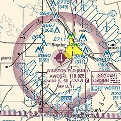
|
| Airport distance calculator |
|---|
|
|
| Sunrise and sunset |
|---|
|
Times for 16-Jul-2026
| | Local
(UTC-5) | | Zulu
(UTC) |
|---|
| Morning civil twilight | | 06:20 | | 11:20 |
| Sunrise | | 06:48 | | 11:48 |
| Sunset | | 20:51 | | 01:51 |
| Evening civil twilight | | 21:19 | | 02:19 |
|
| Current date and time |
|---|
| Zulu (UTC) | 16-Jul-2026 10:31:39 |
|---|
| Local (UTC-5) | 16-Jul-2026 05:31:39 |
|---|
|
| METAR |
|---|
| KSNK | 161015Z AUTO 14004KT 10SM SCT008 BKN014 OVC019 21/20 A3009 RMK AO2 LTG DSNT E AND SE T02070203
|
|
| NOTAMs |
|---|
NOTAMs are issued by the DoD/FAA and will open in a separate window not controlled by AirNav.
|
|


