FAA INFORMATION EFFECTIVE 25 DECEMBER 2025
Location
| FAA Identifier: | U00 |
| Lat/Long: | 44-40-23.2000N 113-21-08.8000W
44-40.386667N 113-21.146667W
44.6731111,-113.3524444
(estimated) |
| Elevation: | 6029 ft. / 1838 m (estimated) |
| Variation: | 17E (1985) |
| Time zone: | UTC -7 (UTC -6 during Daylight Saving Time) |
| Zip code: | 83464 |
Airport Operations
| Airport use: | Open to the public |
| Activation date: | 04/1947 |
| Control tower: | no |
| ARTCC: | SALT LAKE CITY CENTER |
| FSS: | BOISE FLIGHT SERVICE STATION |
| NOTAMs facility: | BOI (NOTAM-D service available) |
| Attendance: | UNATNDD |
| Wind indicator: | lighted |
| Segmented circle: | no |
| Lights: | SS-SR |
Airport Communications
Nearby radio navigation aids
| VOR radial/distance | | VOR name | | Freq | | Var |
|---|
| LKTr111/37.5 | | SALMON VOR/DME | | 113.50 | | 13E |
Airport Services
| Parking: | tiedowns |
| Airframe service: | NONE |
| Powerplant service: | NONE |
| Bottled oxygen: | NONE |
| Bulk oxygen: | NONE |
Runway Information
Runway 11/29
| Dimensions: | 3500 x 140 ft. / 1067 x 43 m |
| Surface: | gravel/dirt, in fair condition
FIRST 2300 FT OF RWY 11 IS GRVL, REST IS DIRT. |
| Runway edge lights: | non-standard
RWY 11/29 LGTS ARE INOP INDEF. |
| RUNWAY 11 | | RUNWAY 29 |
| Latitude: | 44-40.556833N | | 44-40.193833N |
| Longitude: | 113-21.402000W | | 113-20.775000W |
| Elevation: | 5997.0 ft. | | 6014.0 ft. |
| Traffic pattern: | left | | left |
| Runway heading: | 112 magnetic, 129 true | | 292 magnetic, 309 true |
| Obstructions: | 35 ft. pole, lighted, 450 ft. from runway, 100 ft. left and right of centerline, 12:1 slope to clear
NUMEROUS BLDGS IN APCH TO RY 11. | | 4 ft. fence, 75 ft. right of centerline
+17 FT ROAD AT 400 FT ON CNTRLN, +6 FT FENCE AT 350 FT ON CNTRLN. |
Runway 16/34
| Dimensions: | 2903 x 90 ft. / 885 x 27 m |
| Surface: | turf, in fair condition
RWY SFC HAS IMPROVED AND HAS A FAIR CONDITION. |
| RUNWAY 16 | | RUNWAY 34 |
| Latitude: | 44-40.638000N | | 44-40.162833N |
| Longitude: | 113-21.250167W | | 113-21.181000W |
| Elevation: | 5988.0 ft. | | 6029.0 ft. |
| Traffic pattern: | left | | left |
| Runway heading: | 157 magnetic, 174 true | | 337 magnetic, 354 true |
| Obstructions: | 30 ft. pole, 50 ft. from runway, 120 ft. left of centerline, 1:1 slope to clear
+17' FT ROAD AT 200 FT ON CNTRLN +30 FT POLE 250 FT 60 FT L; NMRS OTR OBSTNS TO +10 FT AT 100-400 FT IN APCH ZONE. | | 5 ft. fence, 20 ft. from runway, 4:1 slope to clear |
Airport Ownership and Management from official FAA records
| Ownership: | Publicly-owned |
| Owner: | LEMHI COUNTY
206 COURTHOUSE DR.
SALMON, ID 83467
Phone 208-742-1667 |
| Manager: | CHARLES LAMOURE
206 COURT HOUSE DR
SALMON, ID 83467
Phone 208-940-2171 |
Additional Remarks
| - | RWY 11/29; 16/34; RWYS NOW MKD BY W CEMENT BOUNDARY MARKERS; +3' SAGEBRUSH ADJ TO ALL RWY EDGES. |
| - | AGRICULTURAL IRRIGATION EQUIPMENT +15 FT MAY BE LOCATED WITHIN 50 FT OF RY END 34. |
| - | FOR CD CTC SALT LAKE ARTCC AT 801-320-2568. |
Instrument Procedures
There are no published instrument procedures at U00.
Some nearby airports with instrument procedures:
KSMN - Lemhi County Airport (35 nm NW)
KDLN - Dillon Airport (49 nm NE)
KAOC - Arco-Butte County Airport (64 nm S)
KRVF - Ruby Valley Field Airport (68 nm NE)
KEKS - Ennis - Big Sky Airport (81 nm NE)
|
|

Road maps at:
MapQuest
Bing
Google
| Aerial photo |
|---|
WARNING: Photo may not be current or correct

Do you have a better or more recent aerial photo of Leadore Airport that you would like to share? If so, please send us your photo.
|
| Sectional chart |
|---|
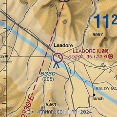
|
| Airport distance calculator |
|---|
|
|
| Sunrise and sunset |
|---|
|
Times for 11-Jan-2026
| | Local
(UTC-7) | | Zulu
(UTC) |
|---|
| Morning civil twilight | | 07:37 | | 14:37 |
| Sunrise | | 08:10 | | 15:10 |
| Sunset | | 17:13 | | 00:13 |
| Evening civil twilight | | 17:46 | | 00:46 |
|
| Current date and time |
|---|
| Zulu (UTC) | 12-Jan-2026 05:41:57 |
|---|
| Local (UTC-7) | 11-Jan-2026 22:41:57 |
|---|
|
| METAR |
|---|
KSMN
34nm NW | 120456Z AUTO 00000KT 9SM CLR M05/M07 A3053 RMK AO2 SLP392 T10501072 FZRANO
|
KLLJ
38nm W | 120455Z AUTO 19004KT 10SM CLR M03/M07 A3049 RMK AO2 SLP368 T10281067
|
KDLN
49nm NE | 120453Z AUTO 21012KT 10SM BKN065 01/M08 A3040 RMK AO2 SLP322 T00111078 $
|
|
| TAF |
|---|
KSMN
34nm NW | 111720Z 1118/1218 00000KT P6SM BKN100 BKN250
|
|
| NOTAMs |
|---|
NOTAMs are issued by the DoD/FAA and will open in a separate window not controlled by AirNav.
|
|

