FAA INFORMATION EFFECTIVE 30 OCTOBER 2025
Location
| FAA Identifier: | U78 |
| Lat/Long: | 42-38-54.6000N 111-34-54.5000W
42-38.910000N 111-34.908333W
42.6485000,-111.5818056
(estimated) |
| Elevation: | 5843 ft. / 1781 m (estimated) |
| Variation: | 15E (1985) |
| From city: | 1 mile SE of SODA SPRINGS, ID |
| Time zone: | UTC -6 (UTC -7 during Standard Time) |
| Zip code: | 83276 |
Airport Operations
| Airport use: | Open to the public |
| Activation date: | 10/1947 |
| Control tower: | no |
| ARTCC: | SALT LAKE CITY CENTER |
| FSS: | BOISE FLIGHT SERVICE STATION |
| NOTAMs facility: | BOI (NOTAM-D service available) |
| Attendance: | UNATNDD
CALL 208-547-2600 OR 208-221-4494 FOR SVC. |
| Wind indicator: | lighted |
| Segmented circle: | yes |
| Lights: | ALL RWY LGTS ARE OTS INDEFLY. |
| Beacon: | white-green (lighted land airport)
ROTG BCN OTS INDEF. |
Airport Communications
Airport Services
| Fuel available: | 100LL |
| Parking: | tiedowns |
| Airframe service: | NONE |
| Powerplant service: | NONE |
| Bottled oxygen: | NONE |
| Bulk oxygen: | NONE |
Runway Information
Runway 16/34
| Dimensions: | 3500 x 50 ft. / 1067 x 15 m |
| Surface: | asphalt, in poor condition
RWY IS IN ROUGH SHAPE: VERY POOR MARKGS, UNTREATED CRACKS, ROUGH & EXPOSED AGGREGATE ASPH. |
| Weight bearing capacity: | |
| Runway edge lights: | non-standard
NSTD LIRL FIRST 300 FT RWY 16 NOT LGTD. |
| Runway edge markings: | RWY NRS ARE VERY DFCLT TO SEE - PAINT IS 90% GONE. |
| RUNWAY 16 | | RUNWAY 34 |
| Latitude: | 42-39.187167N | | 42-38.616333N |
| Longitude: | 111-35.011167W | | 111-34.903667W |
| Elevation: | 5833.0 ft. | | 5843.0 ft. |
| Traffic pattern: | left | | left |
| Markings: | basic, in poor condition | | basic, in poor condition |
| Visual slope indicator: | tri-color VASI on left
TRI COLOR VASI OTS INDFLY. | | tri-color VASI on left
TRI COLOR VASI OTS INDFLY. |
| Runway end identifier lights: | no | | no |
| Obstructions: | 15 ft. road, 200 ft. from runway, 100 ft. right of centerline
+15 FT HWY XS PRIM SFC 50 FT FM EOR; NMRS HIGH VEHICLES; NMRS CLOSE IN OBSTNS ON APCH TO RWY 16. | | none |
Runway 13/31
| Dimensions: | 2500 x 50 ft. / 762 x 15 m |
| Surface: | asphalt, in poor condition
RWY IS VERY POOR, FULL OF OLD & UNTREATED CRACKS, GRASS GROWING THROUGH THEM, HAS NO MARKINGS, AND MANY AREAS WHERE THE TOP LAYER OF ASPH IS FLAKING OFF. |
| RUNWAY 13 | | RUNWAY 31 |
| Latitude: | 42-39.096000N | | 42-38.747167N |
| Longitude: | 111-34.986000W | | 111-34.690500W |
| Elevation: | 5834.0 ft. | | 5843.0 ft. |
| Traffic pattern: | left | | left |
| Markings: | none | | none |
| Obstructions: | 45 ft. pole, 450 ft. from runway, 50 ft. left of centerline, 5:1 slope to clear
+12 FT PARKED ACFT AT 0 FT 115 FT L. | | 40 ft. pline, 600 ft. from runway, 9:1 slope to clear
+9 FT ROAD AT 60 FT ON CNTRLN. |
Airport Ownership and Management from official FAA records
| Ownership: | Publicly-owned |
| Owner: | CITY OF SODA SPRINGS
9 WEST 2ND SOUTH
SODA SPRINGS, ID 83276
Phone 208-547-2600 |
| Manager: | ALAN SKINNER
9 WEST 2ND SOUTH
SODA SPRINGS, ID 83276
Phone 208-547-2600 |
Additional Remarks
| - | SHARPLY DSNDG TRRN NEAR END RWYS 31 & 34. |
| - | NMRS OBSTNS ON APCH TO RWYS 13 & 16. |
| - | FOR CD CTC SALT LAKE ARTCC AT 801-320-2568. |
| - | DAY VFR USE ONLY. |
Instrument Procedures
There are no published instrument procedures at U78.
Some nearby airports with instrument procedures:
1U7 - Bear Lake County Airport (26 nm SE)
KAFO - Afton Lincoln County Airport/General Boyd L Eddins Field (28 nm E)
KPIH - Pocatello Regional Airport (47 nm W)
U02 - McCarley Field Airport (48 nm NW)
KLGU - Logan-Cache Airport (53 nm S)
|
|

Road maps at:
MapQuest
Bing
Google
| Aerial photo |
|---|
WARNING: Photo may not be current or correct

Do you have a better or more recent aerial photo of Allen H Tigert Airport that you would like to share? If so, please send us your photo.
|
| Sectional chart |
|---|
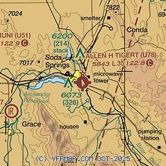
|
| Airport distance calculator |
|---|
|
|
| Sunrise and sunset |
|---|
|
Times for 31-Oct-2025
| | Local
(UTC-6) | | Zulu
(UTC) |
|---|
| Morning civil twilight | | 07:31 | | 13:31 |
| Sunrise | | 08:00 | | 14:00 |
| Sunset | | 18:20 | | 00:20 |
| Evening civil twilight | | 18:49 | | 00:49 |
|
| Current date and time |
|---|
| Zulu (UTC) | 31-Oct-2025 09:10:33 |
|---|
| Local (UTC-6) | 31-Oct-2025 03:10:33 |
|---|
|
| TAF |
|---|
KPIH
46nm W | 310520Z 3106/0106 20006KT P6SM SCT140 SCT180 BKN200 FM311300 VRB03KT P6SM FEW140 FEW200 FM010100 18006KT P6SM SCT140 SCT180
|
|
| NOTAMs |
|---|
NOTAMs are issued by the DoD/FAA and will open in a separate window not controlled by AirNav.
|
|

