FAA INFORMATION EFFECTIVE 15 MAY 2025
Location
| FAA Identifier: | VIS |
| Lat/Long: | 36-19-07.0960N 119-23-34.2990W
36-19.118267N 119-23.571650W
36.3186378,-119.3928608
(estimated) |
| Elevation: | 292.5 ft. / 89.2 m (surveyed) |
| Variation: | 14E (2010) |
| From city: | 4 miles W of VISALIA, CA |
| Time zone: | UTC -7 (UTC -8 during Standard Time) |
| Zip code: | 93277 |
Airport Operations
| Airport use: | Open to the public |
| Control tower: | no |
| ARTCC: | OAKLAND CENTER |
| FSS: | RANCHO MURIETA FLIGHT SERVICE STATION |
| NOTAMs facility: | VIS (NOTAM-D service available) |
| Attendance: | MON-FRI 0800-1800, ALL SAT-SUN 0900-1600 |
| Pattern altitude: | NO DOWNWIND TURNS WHEN DEPARTING RWY 12 UNTIL RCHG TFC PAT ALT. |
| Wind indicator: | lighted |
| Segmented circle: | yes |
| Lights: | ACTVT MALSR RWY 30; REIL RWY 12; PAPI RWY 12 & 30; HIRL RWY 12/30 - CTAF. |
| Beacon: | white-green (lighted land airport)
Operates sunset to sunrise. |
| Landing fee: | no, RON TIEDOWN FEE. |
Airport Communications
| CTAF/UNICOM: | 123.05 |
| WX AWOS-3PT: | 119.925 (559-651-2418) |
| FRESNO APPROACH: | 118.5 |
| FRESNO DEPARTURE: | 118.5 |
| CLEARANCE DELIVERY: | 118.5 |
| WX AWOS-3PT at TLR (10 nm S): | 120.0 (559-686-2613) |
| WX ASOS at HJO (11 nm W): | 134.75 (559-585-8076) |
Nearby radio navigation aids
| VOR radial/distance | | VOR name | | Freq | | Var |
|---|
| TTEr307/30.3 | | TULE VOR/DME | | 116.25 | | 16E |
| NDB name | | Hdg/Dist | | Freq | | Var | | ID |
|---|
| SALYER FARMS | | 008/16.6 | | 205 | | 16E | | COR | -.-. --- .-. |
Airport Services
| Fuel available: | 100LL JET-A
A:SELF-SERVICE FUEL JET A AVBL 24HRS.
100LL:SELF-SERVICE FUEL 100LL AVBL 24 HRS. |
| Parking: | tiedowns |
| Airframe service: | MAJOR |
| Powerplant service: | MAJOR |
| Bottled oxygen: | NONE |
| Bulk oxygen: | NONE |
Runway Information
Runway 12/30
| Dimensions: | 6562 x 150 ft. / 2000 x 46 m |
| Surface: | asphalt/porous friction courses, in good condition |
| Weight bearing capacity: | | Single wheel: | 60.0 | | Double wheel: | 100.0 | | Double tandem: | 160.0 |
|
| Runway edge lights: | high intensity |
| RUNWAY 12 | | RUNWAY 30 |
| Latitude: | 36-19.499287N | | 36-18.737218N |
| Longitude: | 119-24.045732W | | 119-23.097640W |
| Elevation: | 288.7 ft. | | 292.5 ft. |
| Traffic pattern: | left | | left |
| Runway heading: | 121 magnetic, 135 true | | 301 magnetic, 315 true |
| Displaced threshold: | 917 ft. | | no |
| Declared distances: | TORA:6560 TODA:7560 ASDA:6560 LDA:5635 | | TORA:5635 TODA:6635 ASDA:5635 LDA:5635 |
| Markings: | nonprecision, in good condition | | precision, in good condition |
| Visual slope indicator: | 4-light PAPI on left (3.00 degrees glide path) | | 4-light PAPI on left (3.00 degrees glide path) |
| Approach lights: | | | MALSR: 1,400 foot medium intensity approach lighting system with runway alignment indicator lights |
| Runway end identifier lights: | yes | | no |
| Touchdown point: | yes, no lights | | yes, no lights |
| Instrument approach: | | | ILS/DME |
| Obstructions: | 4 ft. fence, 200 ft. from runway, 250 ft. right of centerline
APCH RATIO 20:1 TO DSPLCD THLD. | | 61 ft. tree, 3175 ft. from runway, 725 ft. right of centerline, 48:1 slope to clear |
Helipad H1
| Dimensions: | 45 x 45 ft. / 14 x 14 m |
| Surface: | concrete, in good condition |
| Weight bearing capacity: | | Single wheel: | 18.0 | | Double wheel: | 45.0 | | Double tandem: | 90.0 |
|
| Runway edge markings: | HELIPAD ON PARALLEL TWY; THEN HOVERTAXI TO ADJACENT CONCRETE PARKING PAD; 20000 LBS MAX WGT. |
| Latitude: | 36-19.524000N | | |
| Longitude: | 119-23.945167W | | |
| Elevation: | 294.5 ft. | | |
| Traffic pattern: | left | | left |
| Markings: | basic, in good condition | | |
Airport Ownership and Management from official FAA records
| Ownership: | Publicly-owned |
| Owner: | CITY OF VISALIA
CITY HALL, 707 WEST ACEQUIA
VISALIA, CA 93291
Phone 559-713-4201 |
| Manager: | JODY MILLER
9501 ARPT DRIVE
VISALIA, CA 93277
Phone (559) 713-4282
EMAIL: JODY.MILLER@VISALIA.CITY |
Additional Remarks
| - | RY 30 DESIGNATED CALM WIND RY. |
Instrument Procedures
NOTE: All procedures below are presented as PDF files. If you need a reader for these files, you should download the free Adobe Reader.NOT FOR NAVIGATION. Please procure official charts for flight.
FAA instrument procedures published for use from 15 May 2025 at 0901Z to 13 June 2025 at 0900z.
IAPs - Instrument Approach Procedures |
|---|
| ILS OR LOC RWY 30 | |
download (267KB) |
| RNAV (GPS) RWY 12 | |
download (216KB) |
| RNAV (GPS) RWY 30 | |
download (226KB) |
| NOTE: Special Alternate Minimums apply | |
download (133KB) |
| NOTE: Special Take-Off Minimums/Departure Procedures apply | |
download (348KB) |
Other nearby airports with instrument procedures:
KTLR - Mefford Field Airport (10 nm S)
KHJO - Hanford Municipal Airport (11 nm W)
O32 - Reedley Municipal Airport (21 nm N)
KPTV - Porterville Municipal Airport (24 nm SE)
KNLC - Lemoore Naval Air Station (Reeves Field) (27 nm W)
|
|

Road maps at:
MapQuest
Bing
Google
| Aerial photo |
|---|
WARNING: Photo may not be current or correct
 Photo courtesy of Mark Robinson & HeliHigh.com
Photo taken 07-Jul-2013
looking southeast.
Photo courtesy of Mark Robinson & HeliHigh.com
Photo taken 07-Jul-2013
looking southeast.
Do you have a better or more recent aerial photo of Visalia Municipal Airport that you would like to share? If so, please send us your photo.
|
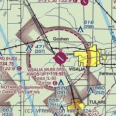
| Sectional chart |
|---|
|
| Airport distance calculator |
|---|
|
|
| Sunrise and sunset |
|---|
|
Times for 25-May-2025
| | Local
(UTC-7) | | Zulu
(UTC) |
|---|
| Morning civil twilight | | 05:16 | | 12:16 |
| Sunrise | | 05:45 | | 12:45 |
| Sunset | | 20:04 | | 03:04 |
| Evening civil twilight | | 20:33 | | 03:33 |
|
| Current date and time |
|---|
| Zulu (UTC) | 25-May-2025 19:59:26 |
|---|
| Local (UTC-7) | 25-May-2025 12:59:26 |
|---|
|
| METAR |
|---|
| KVIS | 251856Z AUTO 24007KT 10SM CLR 24/11 A2999 RMK AO2 SLP155 T02440111 $
|
KHJO
11nm W | 251953Z AUTO 30005KT 10SM CLR 27/09 A2998 RMK AO2 SLP150 T02720089
|
|
| TAF |
|---|
| KVIS | 251720Z 2518/2618 30009KT P6SM FEW200 FM260100 31014KT P6SM SCT250 FM261200 31008KT P6SM SKC
|
|
| NOTAMs |
|---|
NOTAMs are issued by the DoD/FAA and will open in a separate window not controlled by AirNav.
|
|


