FAA INFORMATION EFFECTIVE 09 JULY 2026
Location
| FAA Identifier: | W24 |
| Lat/Long: | 37-22-40.5150N 079-07-20.0830W
37-22.675250N 079-07.334717W
37.3779208,-79.1222453
(estimated) |
| Elevation: | 939 ft. / 286.2 m (surveyed) |
| Variation: | 09W (2005) |
| From city: | 3 miles SE of LYNCHBURG, VA |
| Time zone: | UTC -4 (UTC -5 during Standard Time) |
| Zip code: | 24501 |
Airport Operations
| Airport use: | Open to the public |
| Activation date: | 04/1948 |
| Control tower: | no |
| ARTCC: | WASHINGTON CENTER |
| FSS: | LEESBURG FLIGHT SERVICE STATION |
| NOTAMs facility: | DCA (NOTAM-D service available) |
| Attendance: | APR-OCT 0700-1900, ALL 0700-1800 |
| Pattern altitude: | 1739 ft. MSL |
| Wind indicator: | lighted |
| Segmented circle: | no |
| Lights: | ACTIVATE TRIL RWY 28 CTAF |
Airport Communications
| CTAF/UNICOM: | 123.0 |
| ROANOKE APPROACH: | 125.475 ;EAST OF LYH VORTAC 135.0 ;WEST OF LYH VORTAC |
| ROANOKE DEPARTURE: | 125.475 ;EAST OF LYH VORTAC 135.0 ;WEST OF LYH VORTAC |
| IC: | 135.0 ;WEST OF LYH VORTAC |
| WX ASOS at LYH (5 nm SW): | PHONE 434-205-0756 |
| WX AWOS-3 at 0V4 (15 nm S): | 120.575 (434-283-7826) |
Nearby radio navigation aids
| VOR radial/distance | | VOR name | | Freq | | Var |
|---|
| LYHr041/9.2 | | LYNCHBURG VOR/DME | | 109.20 | | 05W |
| MOLr186/31.4 | | MONTEBELLO VOR/DME | | 115.30 | | 05W |
| NDB name | | Hdg/Dist | | Freq | | Var | | ID |
|---|
| BOJAR | | 048/9.0 | | 385 | | 08W | | LY | .-.. -.-- |
| VINTON | | 082/37.7 | | 277 | | 08W | | VIT | ...- .. - |
Airport Services
| Fuel available: | 100LL |
| Parking: | hangars and tiedowns |
| Airframe service: | MAJOR |
| Powerplant service: | MAJOR |
| Bottled oxygen: | NONE |
| Bulk oxygen: | NONE |
Runway Information
Runway 10/28
| Dimensions: | 2932 x 50 ft. / 894 x 15 m |
| Surface: | asphalt, in fair condition |
| Runway edge lights: | medium intensity |
| Operational restrictions: | LAND RY 28 (WEST) TKOF RY 10 (EAST). |
| RUNWAY 10 | | RUNWAY 28 |
| Latitude: | 37-22.700100N | | 37-22.667972N |
| Longitude: | 079-07.604208W | | 079-07.000357W |
| Elevation: | 938.0 ft. | | 801.4 ft. |
| Traffic pattern: | left | | left |
| Markings: | basic, in good condition | | basic, in good condition |
| Visual slope indicator: | | | tri-color VASI on left |
| Touchdown point: | yes, no lights | | yes, no lights |
| Obstructions: | 59 ft. tree, 315 ft. from runway, 89 ft. right of centerline, 1:1 slope to clear
RWY 10 +47 FT TREE 89 FT FROM THLD 76 FT RHT. | | 20 ft. trees, 310 ft. from runway, 171 ft. left of centerline, 5:1 slope to clear
13 FT LINE OF TREES 180 FT LEFT OF THR ON APCH. |
Airport Ownership and Management from official FAA records
| Ownership: | Privately-owned |
| Owner: | 4180 RICHMOND HIGHWAY LLC
FREEDOM AVIATION, 310 HANGER ROAD
LYNCHBURG, VA 24502
Phone 434-582-3028 |
| Manager: | ROGER BECK
MCLAREN CORP., 4332 RICHMOND HWY
LYNCHBURG, VA 24501
Phone 434-845-8769 |
Additional Remarks
| - | NO TGL. |
| - | DEER ON AND INVOF ARPT. |
| - | ROA TWR SVCS AVBL AT 540-563-1307. |
| - | FOR CD CTC ROANOKE APCH AT 540-563-1307. |
| - | RUNWAY 28 CLOSED FOR TAKE-OFF RUNWAY 10 CLOSED FOR LANDING |
Instrument Procedures
NOTE: All procedures below are presented as PDF files. If you need a reader for these files, you should download the free Adobe Reader.NOT FOR NAVIGATION. Please procure official charts for flight.
FAA instrument procedures published for use from 09 July 2026 at 0901Z to 06 August 2026 at 0900Z.
IAPs - Instrument Approach Procedures |
|---|
| RNAV (GPS) RWY 28 | |
download (179KB) |
| NOTE: Special Take-Off Minimums/Departure Procedures apply | |
download (366KB) |
Other nearby airports with instrument procedures:
KLYH - Lynchburg Regional Airport/Preston Glenn Field (5 nm SW)
W90 - New London Airport (12 nm SW)
0V4 - Brookneal/Campbell County Airport (15 nm S)
W91 - Smith Mountain Lake Airport (28 nm SW)
KFVX - Farmville Regional Airport (33 nm E)
|
|

Road maps at:
MapQuest
Bing
Google
| Aerial photo |
|---|
WARNING: Photo may not be current or correct
 Photo by John Wallace
Photo taken 03-Jan-2008
Photo by John Wallace
Photo taken 03-Jan-2008
Do you have a better or more recent aerial photo of Falwell Airport that you would like to share? If so, please send us your photo.
|
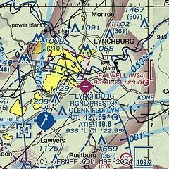
| Sectional chart |
|---|
|
CAUTION: Diagram may not be current

| Airport distance calculator |
|---|
|
|
| Sunrise and sunset |
|---|
|
Times for 28-Jul-2026
| | Local
(UTC-4) | | Zulu
(UTC) |
|---|
| Morning civil twilight | | 05:49 | | 09:49 |
| Sunrise | | 06:18 | | 10:18 |
| Sunset | | 20:27 | | 00:27 |
| Evening civil twilight | | 20:57 | | 00:57 |
|
| Current date and time |
|---|
| Zulu (UTC) | 28-Jul-2026 23:35:57 |
|---|
| Local (UTC-4) | 28-Jul-2026 19:35:57 |
|---|
|
| METAR |
|---|
KLYH
5nm SW | 282254Z 22006KT 10SM CLR 26/19 A2964 RMK AO2 SLP026 T02610194
|
K0V4
15nm S | 282315Z AUTO 26003KT 10SM SCT070 27/23 A2962 RMK AO1
|
|
| TAF |
|---|
KLYH
5nm SW | 282202Z 2822/2918 21007G15KT P6SM FEW035 FM290000 30006KT P6SM SCT060 FM291500 31008KT P6SM SKC
|
|
| NOTAMs |
|---|
NOTAMs are issued by the DoD/FAA and will open in a separate window not controlled by AirNav.
|
|


