FAA INFORMATION EFFECTIVE 12 JUNE 2025
Location
| FAA Identifier: | W90 |
| Lat/Long: | 37-16-18.2200N 079-20-09.2400W
37-16.303667N 079-20.154000W
37.2717278,-79.3359000
(estimated) |
| Elevation: | 842 ft. / 256.6 m (surveyed) |
| Variation: | 09W (2010) |
| From city: | 6 miles SW of FOREST, VA |
| Time zone: | UTC -4 (UTC -5 during Standard Time) |
| Zip code: | 24550 |
Airport Operations
| Airport use: | Open to the public |
| Activation date: | 11/1960 |
| Control tower: | no |
| ARTCC: | WASHINGTON CENTER |
| FSS: | LEESBURG FLIGHT SERVICE STATION |
| NOTAMs facility: | DCA (NOTAM-D service available) |
| Attendance: | UNATNDD |
| Wind indicator: | yes |
| Segmented circle: | no |
Airport Communications
| CTAF/UNICOM: | 122.8 |
| ROANOKE APPROACH: | 135.0 |
| ROANOKE DEPARTURE: | 135.0 |
| IC: | 135.0 |
| WX ASOS at LYH (7 nm NE): | PHONE 434-205-0756 |
| WX AWOS-3 at 0V4 (17 nm SE): | 120.575 (434-283-7826) |
Nearby radio navigation aids
| VOR radial/distance | | VOR name | | Freq | | Var |
|---|
| LYHr287/4.9 | | LYNCHBURG VOR/DME | | 109.20 | | 05W |
| ROAr101/35.3 | | ROANOKE VOR/DME | | 109.40 | | 04W |
| SBVr342/39.0 | | SOUTH BOSTON VORTAC | | 110.40 | | 05W |
| MOLr201/39.3 | | MONTEBELLO VOR/DME | | 115.30 | | 05W |
| NDB name | | Hdg/Dist | | Freq | | Var | | ID |
|---|
| BOJAR | | 285/4.5 | | 385 | | 08W | | LY | .-.. -.-- |
| VINTON | | 089/26.4 | | 277 | | 08W | | VIT | ...- .. - |
Airport Services
| Parking: | tiedowns |
| Airframe service: | NONE |
| Powerplant service: | NONE |
| Bottled oxygen: | NONE |
| Bulk oxygen: | NONE |
Runway Information
Runway 18/36
| Dimensions: | 3164 x 40 ft. / 964 x 12 m |
| Surface: | asphalt, in poor condition
RWY PAVEMENT IN POOR COND. PCI 41-55. |
| Runway edge markings: | RWY NMRS ARE NON STD DIMENSIONS. DRAG RACING MKGS ON RWY. NO HOLD PSN MKGS VSB. |
| Operational restrictions: | RWY 18/36 CLSD DAILY SS-SR. |
| RUNWAY 18 | | RUNWAY 36 |
| Latitude: | 37-16.557333N | | 37-16.050167N |
| Longitude: | 079-20.230000W | | 079-20.078000W |
| Elevation: | 842.0 ft. | | 770.0 ft. |
| Traffic pattern: | left | | left |
| Runway heading: | 176 magnetic, 167 true | | 356 magnetic, 347 true |
| Displaced threshold: | 115 ft. | | no |
| Markings: | NSTD, in fair condition | | NSTD, in fair condition |
| Touchdown point: | yes, no lights | | yes, no lights |
| Obstructions: | 16 ft. road, 201 ft. from runway, 10 ft. left of centerline
TREES; 110 FT LEFT OF CNTRLN. PAVED ROAD RIGHT OF CNTRLN; 125 FT FM END OF PAVEMENT. | | 122 ft. trees, 2372 ft. from runway, 58 ft. right of centerline, 17:1 slope to clear
PVT ROAD USED FOR DRAG RACING LCTD AT THLD RWY 36. |
Airport Ownership and Management from official FAA records
| Ownership: | Privately-owned |
| Owner: | LIBERTY UNIVERSITY, INC.
1971 UNIVERSITY BLVD
LYNCHBURG, VA 24515 |
| Manager: | JOSEPH WALLACE
310 HANGAR RD
LYNCHBURG, VA 24502
Phone 434-582-3028 |
Additional Remarks
| - | STAND, FENCE & TOWER IN PRIM AND/OR TRNSL SFCS WITH GUARDRAIL BOTH SIDES OF RWY 36. |
| - | RWY USED AS DRAG STRIP ON CERTAIN SUNDAYS SUMMER MONTHS. NOTAMED WHEN ARPT CLSD. |
| - | ULTRA LGT ACFT ON & INVOF ARPT. |
| - | ROA TWR SVCS AVBL AT 540-563-1307. |
| - | FOR CD CTC ROANOKE APCH AT 540-563-1307. |
Instrument Procedures
NOTE: All procedures below are presented as PDF files. If you need a reader for these files, you should download the free Adobe Reader.NOT FOR NAVIGATION. Please procure official charts for flight.
FAA instrument procedures published for use from 12 June 2025 at 0901Z to 10 July 2025 at 0900z.
IAPs - Instrument Approach Procedures |
|---|
| RNAV (GPS) RWY 18 **CHANGED** | |
download (186KB) |
| RNAV (GPS) RWY 36 | |
download (174KB) |
| NOTE: Special Take-Off Minimums/Departure Procedures apply | |
download (140KB) |
Other nearby airports with instrument procedures:
KLYH - Lynchburg Regional Airport/Preston Glenn Field (7 nm NE)
W24 - Falwell Airport (12 nm NE)
W91 - Smith Mountain Lake Airport (16 nm SW)
0V4 - Brookneal/Campbell County Airport (17 nm SE)
KROA - Roanoke-Blacksburg Regional Airport/Woodrum Field (31 nm W)
|
|

Road maps at:
MapQuest
Bing
Google
| Aerial photo |
|---|
WARNING: Photo may not be current or correct

Do you have a better or more recent aerial photo of New London Airport that you would like to share? If so, please send us your photo.
|
| Sectional chart |
|---|
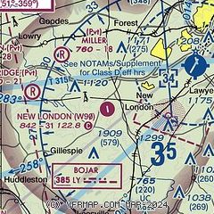
|
| Airport distance calculator |
|---|
|
|
| Sunrise and sunset |
|---|
|
Times for 02-Jul-2025
| | Local
(UTC-4) | | Zulu
(UTC) |
|---|
| Morning civil twilight | | 05:31 | | 09:31 |
| Sunrise | | 06:02 | | 10:02 |
| Sunset | | 20:41 | | 00:41 |
| Evening civil twilight | | 21:11 | | 01:11 |
|
| Current date and time |
|---|
| Zulu (UTC) | 02-Jul-2025 13:30:19 |
|---|
| Local (UTC-4) | 02-Jul-2025 09:30:19 |
|---|
|
| METAR |
|---|
KLYH
7nm NE | 021324Z 00000KT 4SM BR OVC006 22/22 A2997 RMK AO2 CIG 003V010 T02220217
|
K0V4
17nm SE | 021315Z AUTO 17006KT 10SM BKN005 BKN036 OVC050 23/22 A2996 RMK AO1
|
|
| TAF |
|---|
KLYH
7nm NE | 021120Z 0212/0312 19003KT P6SM OVC003 TEMPO 0212/0214 2SM -SHRA BR FM021400 04003KT P6SM VCTS BKN015CB FM021700 05005KT P6SM SCT018 BKN040 FM022000 06005KT P6SM SCT060
|
|
| NOTAMs |
|---|
NOTAMs are issued by the DoD/FAA and will open in a separate window not controlled by AirNav.
|
|


