FAA INFORMATION EFFECTIVE 09 JULY 2026
Location
| FAA Identifier: | E16 |
| Lat/Long: | 37-04-53.7000N 121-35-48.5000W
37-04.895000N 121-35.808333W
37.0815833,-121.5968056
(estimated) |
| Elevation: | 283.8 ft. / 86.5 m (surveyed) |
| Variation: | 15E (2000) |
| From city: | 1 mile E of SAN MARTIN, CA |
| Time zone: | UTC -7 (UTC -8 during Standard Time) |
| Zip code: | 95046 |
Airport Operations
| Airport use: | Open to the public |
| Activation date: | 08/1972 |
| Control tower: | no |
| ARTCC: | OAKLAND CENTER |
| FSS: | OAKLAND FLIGHT SERVICE STATION |
| NOTAMs facility: | E16 (NOTAM-D service available) |
| Attendance: | WED-THU 1000-1700 |
| Wind indicator: | lighted |
| Segmented circle: | yes |
| Lights: | ACTVT MIRL RWY 14/32 - CTAF. PAPI RWYS 14 & 32 ON CONTINUOUSLY. |
| Beacon: | white-green (lighted land airport)
DUSK-DAWN. |
Airport Communications
| CTAF/UNICOM: | 122.7 |
| WX AWOS-3P: | 118.350 (408-918-7724) |
| NORCAL APPROACH: | 124.525 |
| NORCAL DEPARTURE: | 120.1 |
| WX ASOS at WVI (13 nm SW): | 132.275 (831-724-8794) |
| WX AWOS-3 at CVH (14 nm SE): | 120.425 (831-636-4394) |
Nearby radio navigation aids
| VOR radial/distance | | VOR name | | Freq | | Var |
|---|
| SJCr121/24.2 | | SAN JOSE VOR/DME | | 114.10 | | 16E |
| SNSr344/25.1 | | SALINAS VORTAC | | 117.30 | | 17E |
| OSIr103/37.6 | | WOODSIDE VOR/DME | | 113.90 | | 17E |
Airport Services
| Fuel available: | A UL94
UL94:BGNG JANUARY 1, 2022 100LL UNAVBL. |
| Parking: | hangars and tiedowns |
| Airframe service: | MAJOR |
| Powerplant service: | MAJOR |
| Bottled oxygen: | HIGH/LOW |
| Bulk oxygen: | NONE |
Runway Information
Runway 14/32
| Dimensions: | 3095 x 75 ft. / 943 x 23 m |
| Surface: | asphalt, in fair condition |
| Weight bearing capacity: | |
| Runway edge lights: | medium intensity |
| RUNWAY 14 | | RUNWAY 32 |
| Latitude: | 37-05.128607N | | 37-04.661938N |
| Longitude: | 121-35.936730W | | 121-35.680132W |
| Elevation: | 283.6 ft. | | 273.1 ft. |
| Traffic pattern: | left | | right |
| Runway heading: | 141 magnetic, 156 true | | 321 magnetic, 336 true |
| Markings: | nonprecision, in good condition | | nonprecision, in good condition |
| Visual slope indicator: | 2-light PAPI on left (4.00 degrees glide path) | | 2-light PAPI on left (4.00 degrees glide path) |
| Runway end identifier lights: | no | | no |
| Touchdown point: | yes, no lights | | yes, no lights |
| Obstructions: | 41 ft. pole, 1100 ft. from runway, 200 ft. right of centerline, 21:1 slope to clear | | 32 ft. tree, 1040 ft. from runway, 73 ft. right of centerline, 26:1 slope to clear |
Airport Ownership and Management from official FAA records
| Ownership: | Publicly-owned |
| Owner: | COUNTY OF SANTA CLARA
2500 CUNNINGHAM AVE.
SAN JOSE, CA 95148
Phone 408-918-7700
ERIC PETERSON, DIRECTOR OF AIRPORTS. |
| Manager: | SCOTT RIDDLE
2500 CUNNINGHAM
SAN JOSE, CA 95046
Phone 408-918-7700 |
Additional Remarks
| - | NO CROSSWIND TURNS BLO 1300 FT MSL; DEPS CLIMB TO 2000 FT MSL. |
| - | APCHG ACFT FLY DOWNWIND LEGS E OF FREEWAY. |
| - | FOR CD CTC NORCAL APCH AT 916-361-3748. |
Instrument Procedures
NOTE: All procedures below are presented as PDF files. If you need a reader for these files, you should download the free Adobe Reader.NOT FOR NAVIGATION. Please procure official charts for flight.
FAA instrument procedures published for use from 09 July 2026 at 0901Z to 06 August 2026 at 0900Z.
IAPs - Instrument Approach Procedures |
|---|
| RNAV (GPS) RWY 32 | |
download (328KB) |
| NOTE: Special Alternate Minimums apply | |
download (135KB) |
| NOTE: Special Take-Off Minimums/Departure Procedures apply | |
download (369KB) |
Other nearby airports with instrument procedures:
KWVI - Watsonville Municipal Airport (13 nm SW)
KCVH - Hollister Municipal Airport (14 nm SE)
KRHV - Reid-Hillview Airport of Santa Clara County (18 nm NW)
KSJC - Norman Y Mineta San Jose International Airport (23 nm NW)
KSNS - Salinas Municipal Airport (25 nm S)
|
|

Road maps at:
MapQuest
Bing
Google
| Aerial photo |
|---|
WARNING: Photo may not be current or correct
 Photo courtesy of FocalFlight.com
Photo taken 10-Apr-2015
looking east.
Photo courtesy of FocalFlight.com
Photo taken 10-Apr-2015
looking east.
Do you have a better or more recent aerial photo of San Martin Airport that you would like to share? If so, please send us your photo.
|
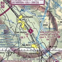
| Sectional chart |
|---|
|
CAUTION: Diagram may not be current

| Airport distance calculator |
|---|
|
|
| Sunrise and sunset |
|---|
|
Times for 18-Jul-2026
| | Local
(UTC-7) | | Zulu
(UTC) |
|---|
| Morning civil twilight | | 05:32 | | 12:32 |
| Sunrise | | 06:01 | | 13:01 |
| Sunset | | 20:24 | | 03:24 |
| Evening civil twilight | | 20:53 | | 03:53 |
|
| Current date and time |
|---|
| Zulu (UTC) | 18-Jul-2026 11:27:49 |
|---|
| Local (UTC-7) | 18-Jul-2026 04:27:49 |
|---|
|
| METAR |
|---|
| KE16 | 180430Z AUTO 14007KT 9SM SCT028 OVC055 16/11 A3001 RMK AO2
|
KWVI
13nm SW | 181053Z AUTO 12003KT 10SM OVC007 13/12 A3003 RMK AO2 SLP169 T01330117
|
KCVH
14nm SE | 181115Z AUTO 00000KT 10SM CLR 13/11 A3003 RMK A01
|
KRHV
18nm NW | 180454Z 30006KT 10SM SKC 16/12 A3000 RMK LAST
|
|
| TAF |
|---|
KSJC
23nm NW | 180520Z 1806/1906 32008KT P6SM FEW014 FM180800 VRB04KT P6SM OVC010 TEMPO 1812/1816 OVC008 FM181700 35005KT P6SM SKC FM182100 32012KT P6SM SKC
|
KSNS
25nm S | 180520Z 1806/1906 28010KT 6SM BR OVC007 FM180900 26004KT 4SM BR OVC005 TEMPO 1811/1815 1/2SM FG OVC003 FM181800 30008KT P6SM SKC FM182000 31015KT P6SM SKC FM190200 30012KT P6SM OVC010
|
|
| NOTAMs |
|---|
NOTAMs are issued by the DoD/FAA and will open in a separate window not controlled by AirNav.
|
|


