FAA INFORMATION EFFECTIVE 15 MAY 2025
Location
| FAA Identifier: | PRN |
| Lat/Long: | 31-50-44.5000N 086-36-38.7000W
31-50.741667N 086-36.645000W
31.8456944,-86.6107500
(estimated) |
| Elevation: | 451.4 ft. / 137.6 m (surveyed) |
| Variation: | 02W (2005) |
| From city: | 2 miles NE of GREENVILLE, AL |
| Time zone: | UTC -5 (UTC -6 during Standard Time) |
| Zip code: | 36037 |
Airport Operations
| Airport use: | Open to the public |
| Activation date: | 05/1962 |
| Control tower: | no |
| ARTCC: | ATLANTA CENTER |
| FSS: | ANNISTON FLIGHT SERVICE STATION |
| NOTAMs facility: | ANB (NOTAM-D service available) |
| Attendance: | MON-FRI 0800-1700, ALL SAT-SUN UNATNDD |
| Pattern altitude: | TPA: 1000 FT AGL CAT A AND B ACFT, 1500 FT AGL CAT C ACFT. |
| Wind indicator: | lighted |
| Segmented circle: | yes |
| Lights: | ACTVT REIL RWY 14 & 32; PAPI RWY 14 & 32; MIRL RWY 14/32 - CTAF. |
| Beacon: | white-green (lighted land airport)
Operates sunset to sunrise. |
Airport Communications
| CTAF/UNICOM: | 122.8 |
| WX ASOS: | 120.0 (334-383-9676) |
- APCH/DEP SVC PRVDD BY ATLANTA ARTCC ON FREQS 120.55/270.25 (MONTGOMERY RCAG).
Nearby radio navigation aids
| VOR radial/distance | | VOR name | | Freq | | Var |
|---|
| MGMr210/27.0 | | MONTGOMERY VORTAC | | 112.10 | | 03E |
| NDB name | | Hdg/Dist | | Freq | | Var | | ID |
|---|
| BLOOD | | 276/25.7 | | 365 | | 04W | | TOI | - --- .. |
| JUDD | | 343/34.3 | | 264 | | 02W | | JUY | .--- ..- -.-- |
Airport Services
| Fuel available: | 100LL
100LL:SVC CHARGE FOR FUEL AFT HRS CALL 334-300-0032. |
| Parking: | hangars and tiedowns |
| Airframe service: | NONE |
| Powerplant service: | NONE |
| Bottled oxygen: | NONE |
| Bulk oxygen: | NONE |
Runway Information
Runway 14/32
| Dimensions: | 5501 x 80 ft. / 1677 x 24 m |
| Surface: | asphalt/grooved, in good condition |
| Weight bearing capacity: | |
| Runway edge lights: | medium intensity |
| RUNWAY 14 | | RUNWAY 32 |
| Latitude: | 31-51.087385N | | 31-50.395753N |
| Longitude: | 086-36.988257W | | 086-36.300432W |
| Elevation: | 451.4 ft. | | 424.2 ft. |
| Traffic pattern: | left | | left |
| Runway heading: | 142 magnetic, 140 true | | 322 magnetic, 320 true |
| Displaced threshold: | no | | 300 ft. |
| Declared distances: | TORA:5200 TODA:5500 ASDA:5200 LDA:5200 | | TORA:5500 TODA:5500 ASDA:5500 LDA:5200 |
| Markings: | nonprecision, in good condition | | nonprecision, in good condition |
| Visual slope indicator: | 2-light PAPI on left (3.00 degrees glide path) | | 2-light PAPI on left (3.00 degrees glide path) |
| Runway end identifier lights: | yes | | yes |
| Touchdown point: | yes, no lights | | yes, no lights |
| Obstructions: | 26 ft. tree, 542 ft. from runway, 38 ft. right of centerline, 13:1 slope to clear | | 11 ft. trees, 341 ft. from runway, 81 ft. right of centerline, 12:1 slope to clear
CLNC SLOPE 37:1 FM DSPLCD THR. |
Airport Ownership and Management from official FAA records
| Ownership: | Publicly-owned |
| Owner: | CITY OF GREENVILLE
PO BOX 158
GREENVILLE, AL 36037
Phone 334-382-2647 |
| Manager: | BRUCE D. EDWARDS
117 COMMANCHE DRIVE
GREENVILLE, AL 36037
Phone 334-382-8166 |
Additional Remarks
| - | FOR CD CTC ATLANTA ARTCC AT 770-210-7692. |
Instrument Procedures
NOTE: All procedures below are presented as PDF files. If you need a reader for these files, you should download the free Adobe Reader.NOT FOR NAVIGATION. Please procure official charts for flight.
FAA instrument procedures published for use from 15 May 2025 at 0901Z to 13 June 2025 at 0900z.
IAPs - Instrument Approach Procedures |
|---|
| RNAV (GPS) RWY 14 | |
download (185KB) |
| RNAV (GPS) RWY 32 | |
download (187KB) |
| NOTE: Special Take-Off Minimums/Departure Procedures apply | |
download (481KB) |
Other nearby airports with instrument procedures:
KMGM - Montgomery Regional Airport (Dannelly Field) (29 nm N)
KTOI - Troy Municipal Airport at N Kenneth Campbell Field (30 nm E)
KGZH - Evergreen Regional Airport/Middleton Field (34 nm SW)
79J - South Alabama Regional Airport at Bill Benton Field (34 nm S)
KMXF - Maxwell Air Force Base (35 nm N)
|
|

Road maps at:
MapQuest
Bing
Google
| Aerial photo |
|---|

|
| Sectional chart |
|---|
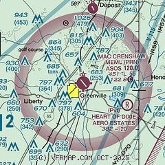
|
| Airport distance calculator |
|---|
|
|
| Sunrise and sunset |
|---|
|
Times for 29-May-2025
| | Local
(UTC-5) | | Zulu
(UTC) |
|---|
| Morning civil twilight | | 05:16 | | 10:16 |
| Sunrise | | 05:43 | | 10:43 |
| Sunset | | 19:44 | | 00:44 |
| Evening civil twilight | | 20:12 | | 01:12 |
|
| Current date and time |
|---|
| Zulu (UTC) | 29-May-2025 14:09:38 |
|---|
| Local (UTC-5) | 29-May-2025 09:09:38 |
|---|
|
| METAR |
|---|
| KPRN | 291400Z AUTO 01004KT 10SM -RA OVC065 21/21 A3007 RMK AO2 RAB1303 SLP129 P0001 T02110206
|
|
| TAF |
|---|
KMGM
29nm N | 291121Z 2912/3012 VRB03KT 4SM SHRA BKN010 FM291800 21004KT 4SM SHRA BKN015 PROB30 2918/2921 4SM TSRA OVC018CB FM300000 28005KT P6SM OVC050 FM300600 18002KT P6SM OVC007 AMD NOT SKED
|
KMXF
34nm N | 291135Z 2911/3017 28003KT 8000 -RA BR SCT012 BKN110 QNH2996INS BECMG 2920/2921 22003KT 9999 NSW BKN012 OVC025 QNH2986INS TX25/2922Z TN18/3010Z
|
|
| NOTAMs |
|---|
NOTAMs are issued by the DoD/FAA and will open in a separate window not controlled by AirNav.
|
|


