FAA INFORMATION EFFECTIVE 20 MARCH 2025
Location
| FAA Identifier: | PZQ |
| Lat/Long: | 45-24-25.5000N 083-48-46.3000W
45-24.425000N 083-48.771667W
45.4070833,-83.8128611
(estimated) |
| Elevation: | 670.3 ft. / 204.3 m (surveyed) |
| Variation: | 07W (1985) |
| From city: | 1 mile S of ROGERS CITY, MI |
| Time zone: | UTC -4 (UTC -5 during Standard Time) |
| Zip code: | 49779 |
Airport Operations
| Airport use: | Open to the public |
| Activation date: | 04/1940 |
| Control tower: | no |
| ARTCC: | MINNEAPOLIS CENTER |
| FSS: | LANSING FLIGHT SERVICE STATION |
| NOTAMs facility: | PZQ (NOTAM-D service available) |
| Attendance: | UNATNDD
CO ROAD CMSNRS OFC LCTD ACRS HWY ATNDD MON-FRI 0800-1700. |
| Wind indicator: | lighted |
| Segmented circle: | yes |
| Lights: | ACTVT REIL RWY 09 & 27; PAPI RWY 09 & 27; MIRL RWY 09/27 - CTAF. |
| Beacon: | white-green (lighted land airport)
Operates sunset to sunrise. |
Airport Communications
| CTAF: | 122.9 |
| WX AWOS-3: | 118.125 (989-734-7419) |
| ALPENA APPROACH: | 128.425 |
| ALPENA DEPARTURE: | 128.425 |
- APCH/DEP SVC PRVDD BY MINNEAPOLIS ARTCC (ZMP) ON FREQS 125.475/269.45 (ALPENA RCAG) WHEN ALPENA APCH CTL CLSD.
Nearby radio navigation aids
| VOR radial/distance | | VOR name | | Freq | | Var |
|---|
| APNr338/22.3 | | ALPENA VORTAC | | 116.50 | | 07W |
| PLNr117/38.2 | | PELLSTON VORTAC | | 111.80 | | 06W |
Airport Services
| Fuel available: | 100LL
100LL:FUEL AVBL O/R CALL AMGR. |
| Parking: | hangars and tiedowns |
| Airframe service: | NONE |
| Powerplant service: | NONE |
| Bottled oxygen: | NONE |
| Bulk oxygen: | NONE |
Runway Information
Runway 9/27
| Dimensions: | 4106 x 75 ft. / 1252 x 23 m |
| Surface: | asphalt, in excellent condition |
| Weight bearing capacity: | |
| Runway edge lights: | medium intensity |
| RUNWAY 9 | | RUNWAY 27 |
| Latitude: | 45-24.415285N | | 45-24.436013N |
| Longitude: | 083-49.251077W | | 083-48.292707W |
| Elevation: | 668.8 ft. | | 670.2 ft. |
| Traffic pattern: | left | | left |
| Runway heading: | 095 magnetic, 088 true | | 275 magnetic, 268 true |
| Displaced threshold: | 220 ft. | | 379 ft. |
| Markings: | nonprecision, in good condition | | nonprecision, in good condition |
| Visual slope indicator: | 4-light PAPI on left (3.00 degrees glide path)
PAPI UNUSBL BYD 9 DEGS LEFT OR RIGHT OF CNTRLN. | | 4-light PAPI on left (3.00 degrees glide path) |
| Runway end identifier lights: | yes | | yes |
| Touchdown point: | yes, no lights | | yes, no lights |
| Obstructions: | 8 ft. fence, 200 ft. from runway, 250 ft. right of centerline, 1:1 slope to clear
APCH RATIO 20:1 TO DTHR. | | 12 ft. sign, marked and lighted, 299 ft. from runway, 193 ft. left of centerline, 8:1 slope to clear
APCH RATIO 20:1 TO DTHR OVR +42 FT MKD/LGTD PLINES, 1040 DIST. |
Airport Ownership and Management from official FAA records
| Ownership: | Publicly-owned |
| Owner: | PRESQUE ISLE COUNTY
658 S BRADLEY HWY
ROGERS CITY, MI 49779-9552
Phone 989-734-3288 |
| Manager: | ALAN STILLER
151 E HURON AVE, PO BOX 110
ROGERS CITY, MI 49779-0110
Phone 906-430-7718
CELL. |
Additional Remarks
| - | DEER & LRG BIRDS ON & INVOF ARPT. |
| - | CALL AMGR TO VFY SNOW REMOVAL & WINTER CONDS. |
| - | TRML BLDG ACES: PRESS 5-3-2-1. |
| - | FOR CD CTC MINNEAPOLIS ARTCC AT 651-463-5588. |
Instrument Procedures
NOTE: All procedures below are presented as PDF files. If you need a reader for these files, you should download the free Adobe Reader.NOT FOR NAVIGATION. Please procure official charts for flight.
FAA instrument procedures published for use from 20 March 2025 at 0901Z to 17 April 2025 at 0900z.
IAPs - Instrument Approach Procedures |
|---|
| RNAV (GPS) RWY 09 | |
download (218KB) |
| RNAV (GPS) RWY 27 | |
download (205KB) |
| NOTE: Special Take-Off Minimums/Departure Procedures apply | |
download (122KB) |
Other nearby airports with instrument procedures:
KAPN - Alpena County Regional Airport (22 nm SE)
KSLH - Cheboygan County Airport (33 nm NW)
6Y1 - Bois Blanc Island Airport (36 nm NW)
KDRM - Drummond Island Airport (36 nm N)
KPLN - Pellston Regional/Emmet County Airport (43 nm W)
|
|

Road maps at:
MapQuest
Bing
Google
| Aerial photo |
|---|
WARNING: Photo may not be current or correct
 Photo by Randal Geiger
Photo taken 19-Aug-2019
looking west.
Photo by Randal Geiger
Photo taken 19-Aug-2019
looking west.
Do you have a better or more recent aerial photo of Presque Isle County Airport that you would like to share? If so, please send us your photo.
|
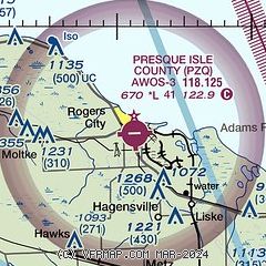
| Sectional chart |
|---|
|
| Airport distance calculator |
|---|
|
|
| Sunrise and sunset |
|---|
|
Times for 15-Apr-2025
| | Local
(UTC-4) | | Zulu
(UTC) |
|---|
| Morning civil twilight | | 06:20 | | 10:20 |
| Sunrise | | 06:51 | | 10:51 |
| Sunset | | 20:20 | | 00:20 |
| Evening civil twilight | | 20:51 | | 00:51 |
|
| Current date and time |
|---|
| Zulu (UTC) | 16-Apr-2025 03:39:29 |
|---|
| Local (UTC-4) | 15-Apr-2025 23:39:29 |
|---|
|
| METAR |
|---|
| KPZQ | 160315Z AUTO 30014G22KT 280V340 10SM OVC018 00/M03 A2987 RMK AO2 T00001030
|
|
| TAF |
|---|
KAPN
23nm SE | 160225Z 1602/1624 31014G23KT P6SM VCSH BKN015 OVC025 FM160600 30011G20KT P6SM OVC025 FM161200 32014G23KT P6SM SCT040
|
|
| NOTAMs |
|---|
NOTAMs are issued by the DoD/FAA and will open in a separate window not controlled by AirNav.
|
|


