FAA INFORMATION EFFECTIVE 23 JANUARY 2025
Location
| FAA Identifier: | 4A9 |
| Lat/Long: | 34-28-25.3000N 085-43-17.0000W
34-28.421667N 085-43.283333W
34.4736944,-85.7213889
(estimated) |
| Elevation: | 876.7 ft. / 267.2 m (surveyed) |
| Variation: | 04W (2010) |
| From city: | 2 miles N of FORT PAYNE, AL |
| Time zone: | UTC -6 (UTC -5 during Daylight Saving Time) |
| Zip code: | 35968 |
Airport Operations
| Airport use: | Open to the public |
| Activation date: | 01/1959 |
| Control tower: | no |
| ARTCC: | ATLANTA CENTER |
| FSS: | ANNISTON FLIGHT SERVICE STATION |
| NOTAMs facility: | 4A9 (NOTAM-D service available) |
| Attendance: | 0700-1700
FOR SVC AFT HRS CALL 256-997-7524. |
| Wind indicator: | lighted |
| Segmented circle: | no |
| Lights: | MIRL RWY 4/22 PRESET LOW INTST, TO INCR INTST ACTVT - CTAF. REIL RWY 04 & 22 ACTVT - CTAF. PAPI RWYS 04 & 22 OPR CONSLY. |
| Beacon: | white-green (lighted land airport)
Operates sunset to sunrise. |
Airport Communications
| CTAF/UNICOM: | 122.8 |
| WX AWOS-3PT: | 119.025 (256-845-5397) |
| WX AWOS-3PT at 4A6 (19 nm NW): | 120.125 (256-259-1148) |
- APCH/DEP SVC PRVDD BY ATLANTA ARTCC ON FREQS 124.5/270.325 (GADSDEN RCAG).
Nearby radio navigation aids
| VOR radial/distance | | VOR name | | Freq | | Var |
|---|
| GADr029/34.8 | | GADSDEN VOR/DME | | 112.30 | | 02E |
| RMGr301/35.2 | | ROME VORTAC | | 115.40 | | 01E |
Airport Services
| Fuel available: | 100LL JET-A+ |
| Parking: | tiedowns |
Runway Information
Runway 4/22
| Dimensions: | 5001 x 100 ft. / 1524 x 30 m |
| Surface: | asphalt/grooved, in good condition |
| Weight bearing capacity: | |
| Runway edge lights: | medium intensity |
| RUNWAY 4 | | RUNWAY 22 |
| Latitude: | 34-28.104200N | | 34-28.739500N |
| Longitude: | 085-43.601027W | | 085-42.966895W |
| Elevation: | 855.8 ft. | | 873.1 ft. |
| Traffic pattern: | left | | left |
| Runway heading: | 044 magnetic, 040 true | | 224 magnetic, 220 true |
| Markings: | nonprecision, in fair condition | | nonprecision, in fair condition |
| Visual slope indicator: | 4-light PAPI on left (4.00 degrees glide path) | | 4-light PAPI on right (3.00 degrees glide path) |
| Runway end identifier lights: | yes | | yes |
| Touchdown point: | yes, no lights | | yes, no lights |
| Obstructions: | 60 ft. tree, lighted, 1528 ft. from runway, 194 ft. right of centerline, 22:1 slope to clear | | 97 ft. tree, 2369 ft. from runway, 340 ft. left of centerline, 22:1 slope to clear |
Airport Ownership and Management from official FAA records
| Ownership: | Publicly-owned |
| Owner: | CITY OF FORT PAYNE
100 ALABAMA AVE NW
FORT PAYNE, AL 35967
Phone 256-845-1524 |
| Manager: | BARRY STONE
2200 TERMINAL DRIVE NW
FORT PAYNE, AL 35968
Phone 256-845-9129 |
Additional Remarks
| - | FOR CD CTC ATLANTA ARTCC AT 770-210-7692. |
Instrument Procedures
NOTE: All procedures below are presented as PDF files. If you need a reader for these files, you should download the free Adobe Reader.NOT FOR NAVIGATION. Please procure official charts for flight.
FAA instrument procedures published for use from 23 January 2025 at 0901Z to 20 February 2025 at 0900z.
IAPs - Instrument Approach Procedures |
|---|
| RNAV (GPS) RWY 04 | |
download (247KB) |
| RNAV (GPS) Y RWY 22 | |
download (238KB) |
| RNAV (GPS) Z RWY 22 | |
download (197KB) |
| NOTE: Special Alternate Minimums apply | |
download (154KB) |
| NOTE: Special Take-Off Minimums/Departure Procedures apply | |
download (480KB) |
Other nearby airports with instrument procedures:
4A6 - Scottsboro Municipal Airport-Word Field (19 nm NW)
KPYP - Centre Piedmont/Cherokee County Regional Airport (24 nm S)
9A5 - Barwick Lafayette Airport (25 nm NE)
8A1 - Guntersville Municipal Airport - Joe Starnes Field (27 nm W)
KRMG - Richard B. Russell Regional Airport - J.H. Towers Field (29 nm E)
|
|

Road maps at:
MapQuest
Bing
Google
| Aerial photo |
|---|
WARNING: Photo may not be current or correct
 Photo taken 01-Aug-2006
from a Cessna 340
Photo taken 01-Aug-2006
from a Cessna 340
Do you have a better or more recent aerial photo of Isbell Field Airport that you would like to share? If so, please send us your photo.
|
| Sectional chart |
|---|
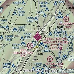
|
| Airport distance calculator |
|---|
|
|
| Sunrise and sunset |
|---|
|
Times for 07-Feb-2025
| | Local
(UTC-6) | | Zulu
(UTC) |
|---|
| Morning civil twilight | | 06:11 | | 12:11 |
| Sunrise | | 06:37 | | 12:37 |
| Sunset | | 17:17 | | 23:17 |
| Evening civil twilight | | 17:43 | | 23:43 |
|
| Current date and time |
|---|
| Zulu (UTC) | 07-Feb-2025 15:31:52 |
|---|
| Local (UTC-6) | 07-Feb-2025 09:31:52 |
|---|
|
| METAR |
|---|
| K4A9 | 071515Z AUTO 03006KT 10SM OVC027 11/04 A3021 RMK AO2 T01140042
|
K4A6
19nm NW | 071515Z AUTO 03008KT 10SM SCT034 BKN041 OVC060 12/02 A3024 RMK AO2
|
|
| TAF |
|---|
KCHA
42nm NE | 071408Z 0714/0812 01007KT P6SM BKN040 PROB30 0720/0724 4SM -SHRA BR FM080000 00000KT P6SM OVC060
|
KHUA
49nm W | 071200Z 0712/0818 02006KT 9000 BR SCT015 BKN030 QNH3012INS BECMG 0805/0806 VRB06KT 8000 BR BKN005 QNH3005INS BECMG 0816/0817 20009KT 8000 BR OVC012 510053 QNH3006INS BECMG 0817/0818 21012G18KT 9000 DZ BKN019 510053 QNH3002INS TX16/0720Z TN10/0712Z
|
|
| NOTAMs |
|---|
NOTAMs are issued by the DoD/FAA and will open in a separate window not controlled by AirNav.
|
|


