FAA INFORMATION EFFECTIVE 30 OCTOBER 2025
Location
| FAA Identifier: | 01G |
| Lat/Long: | 42-44-28.8550N 078-03-07.7330W
42-44.480917N 078-03.128883W
42.7413486,-78.0521481
(estimated) |
| Elevation: | 1558.1 ft. / 474.9 m (surveyed) |
| Variation: | 10W (1985) |
| From city: | 3 miles NW of PERRY, NY |
| Time zone: | UTC -5 (UTC -4 during Daylight Saving Time) |
| Zip code: | 14530 |
Airport Operations
| Airport use: | Open to the public |
| Activation date: | 10/1947 |
| Control tower: | no |
| ARTCC: | CLEVELAND CENTER |
| FSS: | BUFFALO FLIGHT SERVICE STATION |
| NOTAMs facility: | BUF (NOTAM-D service available) |
| Attendance: | MON-FRI IREG |
| Wind indicator: | lighted |
| Segmented circle: | no |
| Lights: | ACTVT REIL RWY 10 & 28; MIRL RWY 10/28 - CTAF. |
| Beacon: | white-green (lighted land airport)
Operates sunset to sunrise. |
Airport Communications
| CTAF/UNICOM: | 122.8 |
| WX AWOS-2: | 118.525 (585-237-0235) |
| WX ASOS at DSV (18 nm SE): | 118.325 (585-335-2380) |
| WX AWOS-3PT at GVQ (18 nm N): | 127.525 (585-343-6369) |
Nearby radio navigation aids
| VOR radial/distance | | VOR name | | Freq | | Var |
|---|
| GEEr257/15.1 | | GENESEO VOR/DME | | 108.20 | | 09W |
| ROCr228/28.1 | | ROCHESTER VOR/DME | | 110.00 | | 12W |
Airport Services
| Fuel available: | 100LL
100LL:24 HRS SELF SVC. |
| Parking: | tiedowns |
| Airframe service: | MAJOR |
| Powerplant service: | MAJOR |
| Bottled oxygen: | NONE |
| Bulk oxygen: | NONE |
Runway Information
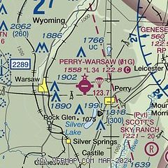
Runway 10/28
| Dimensions: | 3429 x 60 ft. / 1045 x 18 m |
| Surface: | asphalt, in good condition |
| Runway edge lights: | medium intensity |
| RUNWAY 10 | | RUNWAY 28 |
| Latitude: | 42-44.487327N | | 42-44.486397N |
| Longitude: | 078-03.565028W | | 078-02.799162W |
| Elevation: | 1549.3 ft. | | 1545.1 ft. |
| Traffic pattern: | left | | left |
| Runway heading: | 100 magnetic, 090 true | | 280 magnetic, 270 true |
| Displaced threshold: | no | | 639 ft. |
| Markings: | basic, in fair condition | | basic, in fair condition |
| Runway end identifier lights: | yes | | yes |
| Touchdown point: | yes, no lights | | yes, no lights |
| Obstructions: | 35 ft. tree, 201 ft. from runway, 75 ft. right of centerline
20 FT TREES; UP TO 200 FT DSTC, 8 FT LEFT & RIGHT. | | 50 ft. trees, 302 ft. from runway, 135 ft. left of centerline, 2:1 slope to clear
25:1 APCH SLOPE AT DTHR. |
Runway 4/22
| Dimensions: | 1806 x 60 ft. / 550 x 18 m |
| Surface: | turf, in poor condition
RWY 4/22 UNEVEN. RWY & TWY XNGS RUF. RWY SOFT & WET MAR-JUN. CALL FOR FICONS. |
| RUNWAY 4 | | RUNWAY 22 |
| Latitude: | 42-44.342642N | | 42-44.596573N |
| Longitude: | 078-03.132818W | | 078-02.922903W |
| Elevation: | 1543.5 ft. | | 1552.4 ft. |
| Traffic pattern: | left | | left |
| Runway heading: | 041 magnetic, 031 true | | 221 magnetic, 211 true |
| Touchdown point: | yes, no lights | | yes, no lights |
| Obstructions: | 40 ft. trees, 18 ft. from runway, 101 ft. right of centerline | | 6 ft. fence, 123 ft. left of centerline |
Airport Ownership and Management from official FAA records
| Ownership: | Publicly-owned |
| Owner: | TOWNS OF PERRY AND WARSAW
6522 RT. 20A
PERRY, NY 14530
Phone (585) 227-2241
BECKY RYAN & JIM BRICK, CO-SUPERVISORS |
| Manager: | KEN MOSES
6522 RT. 20A
PERRY, NY 14530
Phone 585-237-9938
AMGR CELL 585-353-4666. |
Additional Remarks
| - | TURF RWY 04/22 MAY BE UNUSBL OCT-MAY. |
| - | 8 FT DROPOFF BOTH SIDES, 200 FT DSTC. |
| - | PARALLEL TWY UNLGTD. |
| - | RWY 28: FIRST 700 FT SLOPES UPHILL. |
| - | RWY 4 SAFETY AREA DROPS OFF 100 FT BEFORE RWY BEG, 125 FT L & R OF CNTRLN. |
| - | FIRST 1,700 FT OF RY 10 SLOPES UPHILL. |
| - | FOR CD CTC CLEVELAND ARTCC AT 440-774-0490. |
Instrument Procedures
There are no published instrument procedures at 01G.
Some nearby airports with instrument procedures:
5G0 - Le Roy Airport (15 nm N)
KDSV - Dansville Municipal Airport (18 nm SE)
KGVQ - Genesee County Airport (18 nm N)
9G3 - Akron Airport/Jesson Field (25 nm NW)
KBQR - Buffalo-Lancaster Regional Airport (27 nm NW)
|
|

Road maps at:
MapQuest
Bing
Google
| Aerial photo |
|---|
WARNING: Photo may not be current or correct
 Photo courtesy of Judy M. Bowser (Barnard)
Do you have a better or more recent aerial photo of Perry-Warsaw Airport that you would like to share? If so, please send us your photo.
|
| Sectional chart |
|---|
|
| Airport distance calculator |
|---|
|
|
| Sunrise and sunset |
|---|
|
Times for 21-Nov-2025
| | Local
(UTC-5) | | Zulu
(UTC) |
|---|
| Morning civil twilight | | 06:42 | | 11:42 |
| Sunrise | | 07:12 | | 12:12 |
| Sunset | | 16:44 | | 21:44 |
| Evening civil twilight | | 17:15 | | 22:15 |
|
| Current date and time |
|---|
| Zulu (UTC) | 21-Nov-2025 19:57:00 |
|---|
| Local (UTC-5) | 21-Nov-2025 14:57:00 |
|---|
|
| METAR |
|---|
KDSV
18nm SE | 211854Z AUTO 00000KT 10SM OVC027 11/04 A2993 RMK AO2 SLP146 T01060044
|
KGVQ
18nm N | 211856Z AUTO 25010G19KT 7SM SCT020 08/05 A2989 RMK AO2 SLP128 T00830050
|
KROC
28nm NE | 211901Z 25011KT 10SM FEW020 BKN050 09/06 A2990 RMK AO2 T00940056 $
|
KBUF
32nm W | 211854Z 25012KT 10SM FEW019 BKN046 BKN250 09/05 A2990 RMK AO2 SLP130 T00940050 $
|
KOLE
34nm SW | 211935Z AUTO 26003KT 10SM BKN014 OVC020 05/05 A2991 RMK AO2
|
KIUA
34nm E | 211835Z AUTO 25008KT 10SM SCT016 SCT026 OVC047 09/06 A2990 RMK AO2 T00870056
|
|
| TAF |
|---|
KROC
28nm NE | 211730Z 2118/2218 26012G22KT P6SM OVC015 FM212100 26008KT P6SM BKN035 FM220300 27004KT P6SM BKN035 FM221400 30006KT P6SM BKN020
|
KBUF
32nm W | 211730Z 2118/2218 25013G22KT P6SM BKN015 TEMPO 2118/2120 BKN050 FM212300 25007KT P6SM BKN035 FM220100 27005KT P6SM BKN035 FM220500 30004KT P6SM BKN200
|
|
| NOTAMs |
|---|
NOTAMs are issued by the DoD/FAA and will open in a separate window not controlled by AirNav.
|
|

