FAA INFORMATION EFFECTIVE 09 JULY 2026
Location
| FAA Identifier: | 0V4 |
| Lat/Long: | 37-08-30.2000N 079-00-59.0000W
37-08.503333N 079-00.983333W
37.1417222,-79.0163889
(estimated) |
| Elevation: | 596.6 ft. / 181.8 m (surveyed) |
| Variation: | 09W (2000) |
| From city: | 6 miles NW of BROOKNEAL, VA |
| Time zone: | UTC -4 (UTC -5 during Standard Time) |
| Zip code: | 24554 |
Airport Operations
| Airport use: | Open to the public |
| Activation date: | 10/1982 |
| Control tower: | no |
| ARTCC: | WASHINGTON CENTER |
| FSS: | LEESBURG FLIGHT SERVICE STATION |
| NOTAMs facility: | DCA (NOTAM-D service available) |
| Attendance: | UNATNDD |
| Wind indicator: | lighted |
| Segmented circle: | yes |
| Lights: | DUSK-DAWN. MIRL RWY 06/24 PRESET LOW, TO INCR INTST AND ACTVT REIL RWY 06 & 24; PAPI RWY 06 & 24 - CTAF. |
| Beacon: | white-green (lighted land airport)
Operates sunset to sunrise. |
Airport Communications
| CTAF/UNICOM: | 122.7 |
| WX AWOS-3: | 120.575 (434-283-7826) |
| ROANOKE APPROACH: | 125.475 ;EAST OF LYH VORTAC 135.0 ;WEST OF LYH VORTAC |
| ROANOKE DEPARTURE: | 125.475 ;EAST OF LYH VORTAC 135.0 ;WEST OF LYH VORTAC |
| IC: | 135.0 ;WEST OF LYH VORTAC |
| WX ASOS at LYH (14 nm NW): | PHONE 434-205-0756 |
Nearby radio navigation aids
| VOR radial/distance | | VOR name | | Freq | | Var |
|---|
| LYHr128/12.5 | | LYNCHBURG VOR/DME | | 109.20 | | 05W |
| SBVr005/28.0 | | SOUTH BOSTON VORTAC | | 110.40 | | 05W |
| NDB name | | Hdg/Dist | | Freq | | Var | | ID |
|---|
| BOJAR | | 132/13.0 | | 385 | | 08W | | LY | .-.. -.-- |
Airport Services
| Fuel available: | 100LL |
| Parking: | tiedowns |
Runway Information
Runway 6/24
| Dimensions: | 3798 x 60 ft. / 1158 x 18 m |
| Surface: | asphalt, in fair condition |
| Weight bearing capacity: | |
| Runway edge lights: | medium intensity |
| RUNWAY 6 | | RUNWAY 24 |
| Latitude: | 37-08.316402N | | 37-08.691338N |
| Longitude: | 079-01.296162W | | 079-00.670192W |
| Elevation: | 596.0 ft. | | 588.9 ft. |
| Traffic pattern: | left | | left |
| Runway heading: | 062 magnetic, 053 true | | 242 magnetic, 233 true |
| Markings: | nonprecision, in good condition | | nonprecision, in good condition |
| Visual slope indicator: | 2-light PAPI on right (3.00 degrees glide path) | | 2-light PAPI on left (3.00 degrees glide path) |
| Runway end identifier lights: | yes | | yes |
| Touchdown point: | yes, no lights | | yes, no lights |
| Obstructions: | 9 ft. brush, 205 ft. from runway, 146 ft. right of centerline
10 FT BRUSH ON EACH SIDE OF RWY, 200 FT OFF CNTRLN. | | 7 ft. tree, 309 ft. from runway, 12 ft. right of centerline, 15:1 slope to clear
8 FT BRUSH, 80 FT R ON APCH. |
Airport Ownership and Management from official FAA records
| Ownership: | Publicly-owned |
| Owner: | BROOKNEAL/CAMPBELL CO. AUTH
PO BOX 100, 133 RUNWAY ROAD
RUSTBURG, VA 24588
Phone 434-592-9595 |
| Manager: | JERRY JENNINGS
85 CARDEN LANE, PO BOX 100
GLADYS, VA 24554
Phone 434-841-5360 |
Additional Remarks
| - | ULTRALGT ACTIVITY ON & INVOF ARPT. |
| - | DEER ON & INVOF ARPT. |
| - | ROA TWR SVCS AVBL AT 540-563-1307. |
| - | FOR CD CTC ROANOKE APCH AT 540-563-1307. |
Instrument Procedures
NOTE: All procedures below are presented as PDF files. If you need a reader for these files, you should download the free Adobe Reader.NOT FOR NAVIGATION. Please procure official charts for flight.
FAA instrument procedures published for use from 09 July 2026 at 0901Z to 06 August 2026 at 0900Z.
IAPs - Instrument Approach Procedures |
|---|
| RNAV (GPS) RWY 06 | |
download (242KB) |
| RNAV (GPS) RWY 24 | |
download (198KB) |
| NOTE: Special Alternate Minimums apply | |
download (147KB) |
| NOTE: Special Take-Off Minimums/Departure Procedures apply | |
download (156KB) |
Other nearby airports with instrument procedures:
KLYH - Lynchburg Regional Airport/Preston Glenn Field (14 nm NW)
W24 - Falwell Airport (15 nm N)
W90 - New London Airport (17 nm NW)
W78 - William M Tuck Airport (27 nm S)
W91 - Smith Mountain Lake Airport (28 nm W)
|
|

Road maps at:
MapQuest
Bing
Google
| Aerial photo |
|---|
WARNING: Photo may not be current or correct
 Photo by Bill Wheaton
Photo taken 11-Jun-2010
looking southwest.
Photo by Bill Wheaton
Photo taken 11-Jun-2010
looking southwest.
Do you have a better or more recent aerial photo of Brookneal/Campbell County Airport that you would like to share? If so, please send us your photo.
|
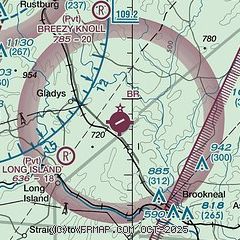
| Sectional chart |
|---|
|
| Airport distance calculator |
|---|
|
|
| Sunrise and sunset |
|---|
|
Times for 18-Jul-2026
| | Local
(UTC-4) | | Zulu
(UTC) |
|---|
| Morning civil twilight | | 05:41 | | 09:41 |
| Sunrise | | 06:11 | | 10:11 |
| Sunset | | 20:34 | | 00:34 |
| Evening civil twilight | | 21:03 | | 01:03 |
|
| Current date and time |
|---|
| Zulu (UTC) | 18-Jul-2026 20:11:51 |
|---|
| Local (UTC-4) | 18-Jul-2026 16:11:51 |
|---|
|
| METAR |
|---|
| K0V4 | 181955Z AUTO 22011G14KT 200V260 10SM CLR 36/23 A2986 RMK AO1
|
KLYH
14nm NW | 181954Z 23011G20KT 10SM FU CLR 33/21 A2988 RMK AO2 LTG DSNT W-NE SLP104 T03280211
|
|
| TAF |
|---|
KLYH
14nm NW | 181725Z 1818/1918 21010G18KT 6SM HZ FU VCTS SCT060CB BKN100 TEMPO 1818/1820 3SM TSRA BR BKN030CB FM182000 25009G19KT P6SM VCTS SCT045CB BKN090 TEMPO 1822/1824 3SM TSRA OVC030CB FM190000 24004KT P6SM SCT060 TEMPO 1910/1912 4SM BR
|
|
| NOTAMs |
|---|
NOTAMs are issued by the DoD/FAA and will open in a separate window not controlled by AirNav.
|
|

