FAA INFORMATION EFFECTIVE 17 APRIL 2025
Location
| FAA Identifier: | 0B7 |
| Lat/Long: | 44-07-02.6000N 072-49-37.2000W
44-07.043333N 072-49.620000W
44.1173889,-72.8270000
(estimated) |
| Elevation: | 1470 ft. / 448 m (estimated) |
| Variation: | 16W (1985) |
| From city: | 2 miles E of WARREN, VT |
| Time zone: | UTC -4 (UTC -5 during Standard Time) |
| Zip code: | 05674 |
Airport Operations
| Airport use: | Open to the public |
| Activation date: | 08/1966 |
| Control tower: | no |
| ARTCC: | BOSTON CENTER |
| FSS: | BURLINGTON FLIGHT SERVICE STATION |
| NOTAMs facility: | BTV (NOTAM-D service available) |
| Attendance: | MAY-OCT 0900-1800 |
| Wind indicator: | yes |
| Segmented circle: | yes
SEGMENTED CIRCLE NSTD. |
Airport Communications
| CTAF/UNICOM: | 123.0 |
| WX ASOS at MPV (13 nm NE): | 132.675 (802-229-2037) |
| WX AWOS-3 at 6B0 (14 nm SW): | 118.575 (802-388-0255) |
Nearby radio navigation aids
| VOR radial/distance | | VOR name | | Freq | | Var |
|---|
| MPVr293/16.4 | | MONTPELIER VOR/DME | | 116.90 | | 16W |
| BTVr153/22.7 | | BURLINGTON VOR/DME | | 117.50 | | 15W |
| NDB name | | Hdg/Dist | | Freq | | Var | | ID |
|---|
| SMUTO | | 028/25.3 | | 221 | | 15W | | DYO | -.. -.-- --- |
| HANOVER | | 327/37.5 | | 276 | | 15W | | LAH | .-.. .- .... |
Airport Services
| Fuel available: | 100LL
100LL:SELF SERVE ONLY DURING HOURS AIRPORT IS OPEN |
| Parking: | tiedowns |
Runway Information
Runway 4/22
| Dimensions: | 2575 x 30 ft. / 785 x 9 m |
| Surface: | asphalt, in excellent condition |
| Weight bearing capacity: | |
| RUNWAY 4 | | RUNWAY 22 |
| Latitude: | 44-06.861855N | | 44-07.225130N |
| Longitude: | 072-49.770925W | | 072-49.467638W |
| Elevation: | 1452.0 ft. | | 1440.0 ft. |
| Traffic pattern: | right | | left |
| Runway heading: | 047 magnetic, 031 true | | 227 magnetic, 211 true |
| Markings: | basic, in good condition | | basic, in good condition |
| Runway end identifier lights: | no | | no |
| Obstructions: | 50 ft. trees, 213 ft. from runway, 50 ft. right of centerline, 1:1 slope to clear
RW04 HAS 50 FOOT TREES 50 FEET RIGHT AND LEFT, 200 FEET FROM RW END | | 49 ft. trees, 395 ft. from runway, 122 ft. left of centerline, 3:1 slope to clear
RWY 22 +56 FT TREES 198 FT FROM THE RWY END AND 119 FT LEFT |
Airport Ownership and Management from official FAA records
| Ownership: | Privately-owned |
| Owner: | GRANITE INTERSECTION INC
BOX ONE
WAITSFIELD, VT 05673
Phone 802-496-2290 |
| Manager: | TOM ANDERSON
PO BOX 123
WARREN, VT 05674
Phone 802-496-2290 |
Additional Remarks
| - | EXTENSIVE GLIDER ACTIVITY ON ARPT SFC TO 18000 FT DALGT HOURS. |
| - | ARPT CLSD NOV-APR. |
| - | NO LINE OF SIGHT BTN RY ENDS. |
| - | TOUCH & GO LDGS NOT PERMITTED. |
| - | OCCASIONAL AEROBATIC ACTIVITY; ARPT MAY BE CLSD DURG THIS ACTIVITY; CHECK NOTAMS. |
| - | GRASS AREAS NOT AUTHORIZED FOR TAXI, TAKEOFFS & LDGS WITHOUT FIRST CHECKING UNICOM OR MANAGEMENT FOR FIELD CONDS. |
| - | FOR CD CTC BURLINGTON APCH AT 802-657-4413, WHEN APCH CLSD CTC BOSTON ARTCC AT 603-879-6859. |
Instrument Procedures
There are no published instrument procedures at 0B7.
Some nearby airports with instrument procedures:
KMPV - Edward F Knapp State Airport (13 nm NE)
KBTV - Patrick Leahy Burlington International Airport (25 nm NW)
KMVL - Morrisville-Stowe State Airport (27 nm N)
4B6 - Ticonderoga Municipal Airport (29 nm SW)
5B9 - Dean Memorial Airport (35 nm E)
|
|

Road maps at:
MapQuest
Bing
Google
| Aerial photo |
|---|
WARNING: Photo may not be current or correct
 Photo by Carl Johnson
Taken in the Summer of 2017
looking southwest.
Photo by Carl Johnson
Taken in the Summer of 2017
looking southwest.
Do you have a better or more recent aerial photo of Warren-Sugarbush Airport that you would like to share? If so, please send us your photo.
|
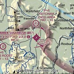
| Sectional chart |
|---|
|
| Airport distance calculator |
|---|
|
|
| Sunrise and sunset |
|---|
|
Times for 03-May-2025
| | Local
(UTC-4) | | Zulu
(UTC) |
|---|
| Morning civil twilight | | 05:09 | | 09:09 |
| Sunrise | | 05:41 | | 09:41 |
| Sunset | | 19:56 | | 23:56 |
| Evening civil twilight | | 20:28 | | 00:28 |
|
| Current date and time |
|---|
| Zulu (UTC) | 03-May-2025 04:56:51 |
|---|
| Local (UTC-4) | 03-May-2025 00:56:51 |
|---|
|
| METAR |
|---|
KMPV
12nm NE | 030351Z AUTO 19003KT 10SM SCT065 16/12 A2988 RMK AO2 SLP118 T01610117
|
K6B0
14nm SW | 030435Z AUTO 22004KT 10SM SCT050 OVC100 17/13 A2985 RMK AO2 T01730133
|
|
| TAF |
|---|
KMPV
12nm NE | 021729Z 0218/0318 21010G18KT P6SM SCT015 BKN045 FM022000 23009G16KT P6SM VCSH SCT040 PROB30 0220/0222 4SM -TSRA BR BKN035CB FM030100 21005KT P6SM BKN045 FM030800 VRB03KT P6SM BKN025 FM031400 VRB03KT P6SM OVC015
|
|
| NOTAMs |
|---|
NOTAMs are issued by the DoD/FAA and will open in a separate window not controlled by AirNav.
|
|


