FAA INFORMATION EFFECTIVE 09 JULY 2026
Location
| FAA Identifier: | 2B7 |
| Lat/Long: | 44-46-06.7000N 069-22-27.9000W
44-46.111667N 069-22.465000W
44.7685278,-69.3744167
(estimated) |
| Elevation: | 197.1 ft. / 60.1 m (surveyed) |
| Variation: | 17W (2010) |
| From city: | 1 mile SE of PITTSFIELD, ME |
| Time zone: | UTC -4 (UTC -5 during Standard Time) |
| Zip code: | 04967 |
Airport Operations
| Airport use: | Open to the public |
| Activation date: | 02/1943 |
| Control tower: | no |
| ARTCC: | BOSTON CENTER |
| FSS: | BANGOR FLIGHT SERVICE STATION |
| NOTAMs facility: | BGR (NOTAM-D service available) |
| Attendance: | 0700-1700 |
| Wind indicator: | lighted |
| Segmented circle: | yes |
| Lights: | ACTVT REIL RWY 18 & 36; PAPI RWY 36; MIRL RWY 18/36 - CTAF. |
| Beacon: | white-green (lighted land airport)
Operates sunset to sunrise. |
Airport Communications
| CTAF/UNICOM: | 122.8 |
| BANGOR APPROACH: | 118.925 |
| BANGOR DEPARTURE: | 118.925 |
| WX AWOS-3PT at WVL (19 nm SW): | 118.375 (207-877-0519) |
Nearby radio navigation aids
| VOR radial/distance | | VOR name | | Freq | | Var |
|---|
| BGRr277/21.8 | | BANGOR VORTAC | | 114.80 | | 19W |
| AUGr052/32.4 | | AUGUSTA VOR/DME | | 114.95 | | 18W |
| NDB name | | Hdg/Dist | | Freq | | Var | | ID |
|---|
| BURNHAM | | 009/4.3 | | 348 | | 18W | | BUP | -... ..- .--. |
Airport Services
| Fuel available: | 100LL JET-A1+
100LL:100LL FUEL AFT HRS, CALL 207-232-2318. |
| Parking: | hangars and tiedowns |
| Airframe service: | MAJOR |
| Powerplant service: | MAJOR |
| Bottled oxygen: | NONE |
| Bulk oxygen: | NONE |
Runway Information
Runway 18/36
| Dimensions: | 4003 x 100 ft. / 1220 x 30 m |
| Surface: | asphalt, in good condition |
| Weight bearing capacity: | | Single wheel: | 38.0 | | Double wheel: | 49.0 |
|
| Runway edge lights: | medium intensity |
| Runway edge markings: | NRS AND CNTRLN FADED OR MISG. |
| RUNWAY 18 | | RUNWAY 36 |
| Latitude: | 44-46.433000N | | 44-45.790003N |
| Longitude: | 069-22.565818W | | 069-22.365125W |
| Elevation: | 197.1 ft. | | 176.3 ft. |
| Traffic pattern: | left | | left |
| Runway heading: | 184 magnetic, 167 true | | 004 magnetic, 347 true |
| Markings: | nonprecision, in poor condition | | nonprecision, in poor condition |
| Visual slope indicator: | | | 4-light PAPI on left (3.00 degrees glide path) |
| Runway end identifier lights: | yes | | yes |
| Touchdown point: | yes, no lights | | yes, no lights |
| Obstructions: | 40 ft. pole, 842 ft. from runway, 257 ft. left of centerline, 16:1 slope to clear
6-10 FT BRUSH, 0-200 FT FM THR, 225-250 FT L OF CNTRLN. | | 5 ft. brush, 249 ft. from runway, 181 ft. right of centerline, 9:1 slope to clear
20 FT TREES 0-50 FT FM THR, 210 FT L OF CNTRLN; 8 FT BRUSH 170-200 FT FM THR, 90 FT L OF CNTRLN. |
Airport Ownership and Management from official FAA records
| Ownership: | Publicly-owned |
| Owner: | TOWN OF PITTSFIELD
112 SOMERSET AVE
PITTSFIELD, ME 04967
Phone 207-487-3136 |
| Manager: | KATHRYN RUTH
112 SOMERSET AVE
PITTSFIELD, ME 04967
Phone 207-487-3136
TOWN MGR. |
Additional Remarks
| - | DEER AND TURKEYS INVOF ARPT. |
| - | FOR CD CTC BANGOR APCH AT 207-561-2500 EXTN 1. |
Instrument Procedures
NOTE: All procedures below are presented as PDF files. If you need a reader for these files, you should download the free Adobe Reader.NOT FOR NAVIGATION. Please procure official charts for flight.
FAA instrument procedures published for use from 09 July 2026 at 0901Z to 06 August 2026 at 0900Z.
IAPs - Instrument Approach Procedures |
|---|
| RNAV (GPS) RWY 18 | |
download (206KB) |
| RNAV (GPS) RWY 36 | |
download (230KB) |
| NOTE: Special Take-Off Minimums/Departure Procedures apply | |
download (548KB) |
Other nearby airports with instrument procedures:
1B0 - Dexter Regional Airport (15 nm N)
KWVL - Waterville Regional Airport (19 nm SW)
KOWK - Central Maine/Norridgewock Airport (21 nm W)
KBGR - Bangor International Airport (23 nm E)
KBST - Belfast Municipal Airport (27 nm SE)
|
|

Road maps at:
MapQuest
Bing
Google
| Aerial photo |
|---|
WARNING: Photo may not be current or correct
 Photo by Karen Frink, PE
Taken in the Fall of 2013
looking south.
Photo by Karen Frink, PE
Taken in the Fall of 2013
looking south.
Do you have a better or more recent aerial photo of Pittsfield Municipal Airport that you would like to share? If so, please send us your photo.
|
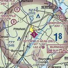
| Sectional chart |
|---|
|
| Airport distance calculator |
|---|
|
|
| Sunrise and sunset |
|---|
|
Times for 10-Jul-2026
| | Local
(UTC-4) | | Zulu
(UTC) |
|---|
| Morning civil twilight | | 04:26 | | 08:26 |
| Sunrise | | 05:03 | | 09:03 |
| Sunset | | 20:23 | | 00:23 |
| Evening civil twilight | | 20:59 | | 00:59 |
|
| Current date and time |
|---|
| Zulu (UTC) | 10-Jul-2026 10:39:23 |
|---|
| Local (UTC-4) | 10-Jul-2026 06:39:23 |
|---|
|
| METAR |
|---|
KWVL
20nm SW | 101010Z AUTO 01003KT 5SM BR FEW001 BKN080 BKN120 20/20 A2969 RMK AO2
|
KBGR
24nm E | 100953Z 00000KT 4SM BR BCFG FEW002 SCT065 OVC110 20/20 A2969 RMK AO2 RAB13E21B39E50 SLP048 PRESENT WX VCSH P0000 T02000200
|
KAUG
33nm SW | 100953Z AUTO 00000KT 6SM BR BKN080 BKN100 BKN120 21/20 A2970 RMK AO2 SLP057 T02060200
|
|
| TAF |
|---|
KBGR
24nm E | 100852Z 1008/1106 VRB02KT 6SM BR VCSH OVC090 TEMPO 1009/1012 4SM -RA BR BKN010 FM101300 32008KT P6SM SCT045 FM110100 VRB04KT P6SM FEW100
|
|
| NOTAMs |
|---|
NOTAMs are issued by the DoD/FAA and will open in a separate window not controlled by AirNav.
|
|

