FAA INFORMATION EFFECTIVE 09 JULY 2026
Location
| FAA Identifier: | 2F4 |
| Lat/Long: | 33-10-51.6000N 101-49-09.8000W
33-10.860000N 101-49.163333W
33.1810000,-101.8193889
(estimated) |
| Elevation: | 3126 ft. / 953 m (estimated) |
| Variation: | 09E (1985) |
| From city: | 1 mile NW of TAHOKA, TX |
| Time zone: | UTC -5 (UTC -6 during Standard Time) |
| Zip code: | 79373 |
Airport Operations
| Airport use: | Open to the public |
| Activation date: | 03/1960 |
| Control tower: | no |
| ARTCC: | FORT WORTH CENTER |
| FSS: | FORT WORTH FLIGHT SERVICE STATION |
| NOTAMs facility: | FTW (NOTAM-D service available) |
| Attendance: | UNATNDD ON CALL
ATTENDANT ON CALL 806-759-1455. |
| Wind indicator: | lighted |
| Segmented circle: | no |
| Lights: | SS-SR |
| Beacon: | white-green (lighted land airport) |
Airport Communications
Nearby radio navigation aids
| VOR radial/distance | | VOR name | | Freq | | Var |
|---|
| LBBr160/31.8 | | LUBBOCK VORTAC | | 109.20 | | 11E |
Airport Services
| Parking: | hangars and tiedowns |
Runway Information
Runway 17/35
| Dimensions: | 3278 x 50 ft. / 999 x 15 m |
| Surface: | asphalt, in good condition |
| Weight bearing capacity: | |
| Runway edge lights: | medium intensity |
| RUNWAY 17 | | RUNWAY 35 |
| Traffic pattern: | right | | left |
| Markings: | basic, in good condition | | basic, in good condition |
| Obstructions: | 10 ft. other, 420 ft. from runway, 22:1 slope to clear
IRRIGATION EQUIP. | | 10 ft. road, 212 ft. from runway, 16 ft. right of centerline, 1:1 slope to clear |
Runway 8/26
| Dimensions: | 2543 x 33 ft. / 775 x 10 m |
| Surface: | gravel/dirt, in fair condition |
| Weight bearing capacity: | |
| RUNWAY 8 | | RUNWAY 26 |
| Latitude: | 33-10.863410N | | 33-10.856267N |
| Longitude: | 101-49.411967W | | 101-48.913247W |
| Elevation: | 3120.0 ft. | | 3123.0 ft. |
| Traffic pattern: | left | | right |
| Runway heading: | 082 magnetic, 091 true | | 262 magnetic, 271 true |
| Obstructions: | 12 ft. road, 30 ft. from runway, 2:1 slope to clear | | 11 ft. road, 30 ft. from runway, 3:1 slope to clear |
Airport Ownership and Management from official FAA records
| Ownership: | Publicly-owned |
| Owner: | CITY OF TAHOKA
1807 MAIN ST, PO BOX 300
TAHOKA, TX 79373
Phone 806-561-4211 |
| Manager: | SAMMY PRIDMORE
1807 MAIN ST,, PO BOX 300
TAHOKA, TX 79373
Phone 806-759-1455 |
Additional Remarks
| - | RWY 08/26 THRS & RWY EDGES NOT DEFINED. |
| - | 20 FT AGL IRRIGATION EQUIP 400 FT NORTH AER 35. |
| - | FOR CD CTC FORT WORTH ARTCC AT 817-858-7584. |
| - | RWY 8/26 5 FT DROP OFF EACH END. |
Instrument Procedures
There are no published instrument procedures at 2F4.
Some nearby airports with instrument procedures:
F82 - Lubbock Executive Airpark (18 nm N)
KBFE - Terry County Airport (19 nm W)
F49 - City of Slaton/Larry T Neal Memorial Airport (20 nm NE)
KLUV - Lamesa Municipal Airport (26 nm S)
KLBB - Lubbock Preston Smith International Airport (29 nm N)
|
|

Road maps at:
MapQuest
Bing
Google
| Aerial photo |
|---|
WARNING: Photo may not be current or correct

Do you have a better or more recent aerial photo of T-Bar Airport that you would like to share? If so, please send us your photo.
|
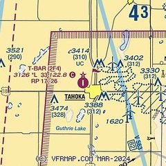
| Sectional chart |
|---|
|
| Airport distance calculator |
|---|
|
|
| Sunrise and sunset |
|---|
|
Times for 28-Jul-2026
| | Local
(UTC-5) | | Zulu
(UTC) |
|---|
| Morning civil twilight | | 06:31 | | 11:31 |
| Sunrise | | 06:59 | | 11:59 |
| Sunset | | 20:49 | | 01:49 |
| Evening civil twilight | | 21:16 | | 02:16 |
|
| Current date and time |
|---|
| Zulu (UTC) | 29-Jul-2026 01:02:57 |
|---|
| Local (UTC-5) | 28-Jul-2026 20:02:57 |
|---|
|
| METAR |
|---|
KLUV
26nm S | 290030Z AUTO 16011KT 10SM CLR 35/13 A2989 RMK AO2
|
KLBB
29nm N | 290053Z 15010KT 10SM FEW250 35/10 A2990 RMK AO2 SLP066 T03500100
|
KLLN
36nm NW | 290055Z AUTO 16010KT 10SM CLR 34/08 A2993 RMK AO2
|
|
| TAF |
|---|
KLBB
29nm N | 281720Z 2818/2918 17011KT P6SM FEW250
|
|
| NOTAMs |
|---|
NOTAMs are issued by the DoD/FAA and will open in a separate window not controlled by AirNav.
|
|


