FAA INFORMATION EFFECTIVE 09 JULY 2026
Location
| FAA Identifier: | 38D |
| Lat/Long: | 40-56-53.0910N 080-51-43.4950W
40-56.884850N 080-51.724917W
40.9480808,-80.8620819
(estimated) |
| Elevation: | 1162 ft. / 354 m (estimated) |
| Variation: | 07W (1985) |
| From city: | 3 miles N of SALEM, OH |
| Time zone: | UTC -4 (UTC -5 during Standard Time) |
| Zip code: | 44460 |
Airport Operations
| Airport use: | Open to the public |
| Activation date: | 10/1952 |
| Control tower: | no |
| ARTCC: | CLEVELAND CENTER |
| FSS: | CLEVELAND FLIGHT SERVICE STATION |
| NOTAMs facility: | CLE (NOTAM-D service available) |
| Attendance: | IREG |
| Wind indicator: | lighted |
| Segmented circle: | no |
| Lights: | ACTVT NSTD LIRL RWY 10L/28R - CTAF. |
Airport Communications
| CTAF/UNICOM: | 122.7 |
| CLEVELAND APPROACH: | 125.5 |
| CLEVELAND DEPARTURE: | 125.5 |
- APCH/DEP SVC PRVDD BY CLEVELAND APCH (CLE) 0600-0100. APCH/DEP SVC PRVDD BY CLEVELAND ARTCC (ZOB) ON FREQS 120.6/379.275 (MOUNT HOPE RCAG) 0100-0600.
Nearby radio navigation aids
| VOR radial/distance | | VOR name | | Freq | | Var |
|---|
| ACOr126/18.1 | | AKRON VOR/DME | | 114.40 | | 04W |
| BSVr068/28.7 | | BRIGGS VOR/DME | | 114.05 | | 04W |
| EWCr292/30.4 | | ELLWOOD CITY VOR/DME | | 115.80 | | 08W |
| NDB name | | Hdg/Dist | | Freq | | Var | | ID |
|---|
| CASTLE | | 266/20.7 | | 272 | | 09W | | UCP | ..- -.-. .--. |
Airport Services
| Fuel available: | 100LL
100LL:100LL AVBL H24 SELF SVC VIA CREDIT CARD. |
| Parking: | hangars and tiedowns |
| Airframe service: | NONE |
| Powerplant service: | NONE |
| Bottled oxygen: | NONE |
| Bulk oxygen: | NONE |
Runway Information
Runway 10L/28R
| Dimensions: | 3404 x 50 ft. / 1038 x 15 m |
| Surface: | asphalt, in excellent condition |
| Weight bearing capacity: | | Single wheel: | 8.0, ALL PAVEMENT RSTRD ACFT MAX GWT LESS THAN 8000 LBS. |
|
| Runway edge lights: | non-standard
NSTD LIRL DUE TO LAYOUT & COLORS; 2829 FT LGTD. |
| Runway edge markings: | NSTD DUE TO THR MRKGS. |
| RUNWAY 10L | | RUNWAY 28R |
| Latitude: | 40-56.894333N | | 40-56.893833N |
| Longitude: | 080-52.132000W | | 080-51.392500W |
| Elevation: | 1153.0 ft. | | 1162.0 ft. |
| Traffic pattern: | left | | left |
| Runway heading: | 097 magnetic, 090 true | | 277 magnetic, 270 true |
| Displaced threshold: | no | | 266 ft. |
| Markings: | NSTD, in good condition | | NSTD, in good condition |
| Touchdown point: | yes, no lights | | yes, no lights |
| Obstructions: | 40 ft. trees, 460 ft. from runway, 200 ft. left and right of centerline, 6:1 slope to clear | | 45 ft. hill, 950 ft. from runway, 200 ft. left and right of centerline, 16:1 slope to clear
APCH SLP 15:1 TO DTHR OVR +22 FT ROAD, 80 FT DIST, 125 FT L/R. |
Runway 10R/28L
| Dimensions: | 2550 x 60 ft. / 777 x 18 m |
| Surface: | turf, in good condition |
| RUNWAY 10R | | RUNWAY 28L |
| Latitude: | 40-56.872500N | | 40-56.872500N |
| Longitude: | 080-51.952000W | | 080-51.398167W |
| Elevation: | 1153.0 ft. | | 1162.0 ft. |
| Traffic pattern: | left | | left |
| Runway heading: | 097 magnetic, 090 true | | 277 magnetic, 270 true |
| Markings: | none | | none |
| Touchdown point: | yes, no lights | | yes, no lights |
| Obstructions: | 85 ft. trees, 57 ft. right of centerline
+80-85 FT TREES, 0-15 FT DIST, 33-57 FT R. | | 35 ft. pole, 89 ft. from runway, 50 ft. left of centerline, 2:1 slope to clear |
Airport Ownership and Management from official FAA records
| Ownership: | Privately-owned |
| Owner: | SALEM AIRPARK LLC
970 WINDHAM CT STE 7
BOARDMAN, OH 44512-5082
Phone 330-726-6385 |
| Manager: | VICK SURACI
11718 SALEM WARREN RD
SALEM, OH 44460-9667
Phone 724-316-6026
CELL. |
Additional Remarks
| - | DRAG STRIP 3500 FT SE LOOKS LIKE ARPT. |
| - | FOR CD CTC CLEVELAND APCH AT 216-352-2323, WHEN APCH CLSD CTC CLEVELAND ARTCC AT 440-774-0223/0490. |
| - | DEER, BIRDS, & WILDLIFE ON & INVOF ARPT. |
| - | RWY 10R/28L: CTC AMGR FOR TURF CONDS PRIOR TO USE. |
| - | RWY 10L/28R: ONLY 2829 FT AVBL FOR NGT OPS. |
| - | RWY 28R: ACFT ON TURN FM DOWNWIND TO BASE MAY BE OBSC BY TREES IN APCH. |
Instrument Procedures
NOTE: All procedures below are presented as PDF files. If you need a reader for these files, you should download the free Adobe Reader.NOT FOR NAVIGATION. Please procure official charts for flight.
FAA instrument procedures published for use from 09 July 2026 at 0901Z to 06 August 2026 at 0900Z.
IAPs - Instrument Approach Procedures |
|---|
| RNAV (GPS)-A | |
download (187KB) |
| NOTE: Special Take-Off Minimums/Departure Procedures apply | |
download (477KB) |
Other nearby airports with instrument procedures:
3G6 - Tri-City Airport (7 nm W)
4G4 - Youngstown Elser Metro Airport (8 nm E)
02G - Columbiana County Airport (19 nm SE)
KYNG - Youngstown/Warren Regional Airport (21 nm NE)
KUCP - New Castle Municipal Airport (21 nm E)
|
|

Road maps at:
MapQuest
Bing
Google
| Aerial photo |
|---|
WARNING: Photo may not be current or correct
 Photo by Brad Smith
Photo taken 04-May-2008
Photo by Brad Smith
Photo taken 04-May-2008
Do you have a better or more recent aerial photo of Salem Airpark that you would like to share? If so, please send us your photo.
|
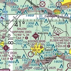
| Sectional chart |
|---|
|
| Airport distance calculator |
|---|
|
|
| Sunrise and sunset |
|---|
|
Times for 01-Aug-2026
| | Local
(UTC-4) | | Zulu
(UTC) |
|---|
| Morning civil twilight | | 05:50 | | 09:50 |
| Sunrise | | 06:20 | | 10:20 |
| Sunset | | 20:39 | | 00:39 |
| Evening civil twilight | | 21:10 | | 01:10 |
|
| Current date and time |
|---|
| Zulu (UTC) | 01-Aug-2026 12:38:02 |
|---|
| Local (UTC-4) | 01-Aug-2026 08:38:02 |
|---|
|
| METAR |
|---|
KYNG
20nm NE | 011151Z 11006KT 10SM BKN160 OVC240 20/17 A2990 RMK AO2 SLP116 T02000167 10211 20178 56007 $
|
KUCP
21nm E | 011156Z AUTO 00000KT 10SM CLR 19/18 A2991 RMK AO2 SLP137 T01940183 10194 20178 56007
|
KPOV
24nm NW | 011215Z AUTO 00000KT 10SM CLR 20/17 A2990 RMK AO2 T01980172
|
KBVI
24nm SE | 011215Z AUTO 00000KT 10SM CLR 22/16 A2991 RMK AO2 T02170164
|
KCAK
27nm W | 011151Z 14005KT 10SM BKN150 BKN200 21/17 A2989 RMK AO2 SLP111 T02110167 10222 20206 58004 $
|
KAKR
28nm W | 011154Z AUTO 18003KT 10SM CLR 21/17 A2988 RMK AO2 SLP109 T02110167 10222 20200 57003
|
KPIT
38nm SE | 011151Z 08004KT 10SM OVC180 20/17 A2990 RMK AO2 SLP123 T02000167 10211 20183 56008
|
KPHD
38nm SW | 011153Z AUTO 11003KT 10SM CLR 19/18 A2987 RMK AO2 SLP110 T01940183 10194 20183 56009
|
|
| TAF |
|---|
KYNG
20nm NE | 011120Z 0112/0212 VRB05KT P6SM FEW060 FM011800 15006KT P6SM OVC100 FM020000 VRB03KT P6SM OVC100 PROB30 0201/0206 4SM -TSRA OVC025CB FM020600 15006KT 6SM -SHRA VCTS BKN025CB FM020800 15008KT 6SM -SHRA OVC015 FM021000 15006KT 4SM -RA OVC008
|
KBVI
24nm SE | 011136Z 0112/0212 00000KT P6SM BKN250 FM011500 16005KT P6SM FEW050 BKN150 FM020300 12005KT P6SM -SHRA OVC050 PROB30 0207/0211 4SM -TSRA OVC035CB
|
|
| NOTAMs |
|---|
NOTAMs are issued by the DoD/FAA and will open in a separate window not controlled by AirNav.
|
|


