FAA INFORMATION EFFECTIVE 30 OCTOBER 2025
Location
| FAA Identifier: | UCP |
| Lat/Long: | 41-01-31.1990N 080-24-48.1060W
41-01.519983N 080-24.801767W
41.0253331,-80.4133628
(estimated) |
| Elevation: | 1072.3 ft. / 326.8 m (surveyed) |
| Variation: | 09W (2005) |
| From city: | 4 miles NW of NEW CASTLE, PA |
| Time zone: | UTC -5 (UTC -4 during Daylight Saving Time) |
| Zip code: | 16116 |
Airport Operations
| Airport use: | Open to the public |
| Activation date: | 12/1938 |
| Control tower: | no |
| ARTCC: | CLEVELAND CENTER |
| FSS: | ALTOONA FLIGHT SERVICE STATION |
| NOTAMs facility: | AOO (NOTAM-D service available) |
| Attendance: | 0830-1700 |
| Wind indicator: | lighted |
| Segmented circle: | yes |
| Lights: | ACTVT REILS RWY 05 & 23; PAPI RWY 05, 13, 23; MIRL RWY 05/23 - CTAF. |
| Beacon: | white-green (lighted land airport)
Operates sunset to sunrise. |
Airport Communications
| CTAF/UNICOM: | 123.0 |
| WX AWOS-3PT: | 124.175 ((724) 652-4184) |
| YOUNGSTOWN APPROACH: | 133.95 |
| YOUNGSTOWN DEPARTURE: | 133.95 |
| WX AWOS-3PT at BVI (15 nm S): | 118.35 (724-843-1024) |
| WX AWOS-3PT at PJC (18 nm SE): | 118.45 (724-452-5304) |
| WX ASOS at YNG (19 nm NW): | PHONE 330-856-9357 |
- APCH/DEP SVC PRVDD BY CLEVELAND ARTCC (ZOB) ON FREQS 126.725/291.65(DUBOIS RCAG) WHEN YOUNGSTOWN APCH CTL CLSD.
Nearby radio navigation aids
| VOR radial/distance | | VOR name | | Freq | | Var |
|---|
| EWCr331/15.1 | | ELLWOOD CITY VOR/DME | | 115.80 | | 08W |
| FKLr231/(35.3) | | FRANKLIN VOR | | 109.60 | | 06W |
| ACOr102/36.0 | | AKRON VOR/DME | | 114.40 | | 04W |
| NDB name | | Hdg/Dist | | Freq | | Var | | ID |
|---|
| CASTLE | | at field | | 272 | | 09W | | UCP | ..- -.-. .--. |
| FETCH | | 150/13.4 | | 338 | | 08W | | YN | -.-- -. |
Airport Services
| Fuel available: | 100LL |
| Parking: | hangars and tiedowns |
| Airframe service: | MAJOR |
| Powerplant service: | MAJOR |
| Bottled oxygen: | NONE |
| Bulk oxygen: | NONE |
Runway Information
Runway 5/23
| Dimensions: | 3995 x 75 ft. / 1218 x 23 m |
| Surface: | asphalt, in good condition |
| Weight bearing capacity: | |
| Runway edge lights: | medium intensity |
| RUNWAY 5 | | RUNWAY 23 |
| Latitude: | 41-01.347353N | | 41-01.852892N |
| Longitude: | 080-25.087757W | | 080-24.531903W |
| Elevation: | 1022.0 ft. | | 1007.0 ft. |
| Traffic pattern: | left | | left |
| Runway heading: | 048 magnetic, 039 true | | 228 magnetic, 219 true |
| Markings: | nonprecision, in fair condition | | nonprecision, in good condition |
| Visual slope indicator: | 4-light PAPI on left (3.00 degrees glide path) | | 4-light PAPI on left (3.00 degrees glide path) |
| Runway end identifier lights: | yes | | yes |
| Touchdown point: | yes, no lights | | yes, no lights |
| Obstructions: | 44 ft. trees, 663 ft. from runway, 309 ft. right of centerline, 10:1 slope to clear | | 47 ft. trees, 563 ft. from runway, 284 ft. right of centerline, 7:1 slope to clear
20 FT TREES: 30 FT FM RWY END, 205 FT RIGHT. |
Runway 13/31
| Dimensions: | 2855 x 100 ft. / 870 x 30 m |
| Surface: | asphalt, in fair condition |
| Weight bearing capacity: | |
| RUNWAY 13 | | RUNWAY 31 |
| Latitude: | 41-01.520967N | | 41-01.294708N |
| Longitude: | 080-25.062512W | | 080-24.518403W |
| Elevation: | 1016.3 ft. | | 1072.3 ft. |
| Traffic pattern: | left | | left |
| Runway heading: | 127 magnetic, 118 true | | 307 magnetic, 298 true |
| Displaced threshold: | no | | 108 ft. |
| Markings: | basic, in good condition | | basic, in good condition |
| Visual slope indicator: | 2-light PAPI on left (3.00 degrees glide path) | | |
| Touchdown point: | yes, no lights | | yes, no lights |
Airport Ownership and Management from official FAA records
| Ownership: | Publicly-owned |
| Owner: | LAWRENCE CO. AIRPORT AUTHORITY
406 FRANK FARONE DRIVE
NEW CASTLE, PA 16101
Phone (724) 652-5546 |
| Manager: | JAMES FARRIS, JR.
406 FRANK FARONE DRIVE
NEW CASTLE, PA 16101
Phone (724) 651-2100 |
Additional Remarks
| - | DEER ON AND INVOF AIRPORT. |
| - | FOR CD CTC YOUNGSTOWN APCH AT 330-856-4806, WHEN APCH CLSD CTC CLEVELAND ARTCC AT 440-774-0234. |
Instrument Procedures
NOTE: All procedures below are presented as PDF files. If you need a reader for these files, you should download the free Adobe Reader.NOT FOR NAVIGATION. Please procure official charts for flight.
FAA instrument procedures published for use from 30 October 2025 at 0901Z to 27 November 2025 at 0900Z.
IAPs - Instrument Approach Procedures |
|---|
| RNAV (GPS) RWY 05 | |
download (232KB) |
| RNAV (GPS) RWY 23 | |
download (224KB) |
| NOTE: Special Alternate Minimums apply | |
download (123KB) |
| NOTE: Special Take-Off Minimums/Departure Procedures apply | |
download (149KB) |
Other nearby airports with instrument procedures:
4G4 - Youngstown Elser Metro Airport (13 nm W)
29D - Grove City Airport (13 nm NE)
KBVI - Beaver County Airport (15 nm S)
KPJC - Zelienople Municipal Airport (18 nm SE)
KYNG - Youngstown/Warren Regional Airport (19 nm NW)
|
|

Road maps at:
MapQuest
Bing
Google
| Aerial photo |
|---|
WARNING: Photo may not be current or correct
 Photo by David Newcomer
Photo taken 11-Jul-2010
from 6,500' altitude looking west.
Photo by David Newcomer
Photo taken 11-Jul-2010
from 6,500' altitude looking west.
Do you have a better or more recent aerial photo of New Castle Municipal Airport that you would like to share? If so, please send us your photo.
|
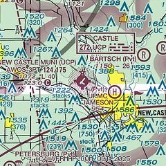
| Sectional chart |
|---|
|
| Airport distance calculator |
|---|
|
|
| Sunrise and sunset |
|---|
|
Times for 10-Nov-2025
| | Local
(UTC-5) | | Zulu
(UTC) |
|---|
| Morning civil twilight | | 06:35 | | 11:35 |
| Sunrise | | 07:04 | | 12:04 |
| Sunset | | 17:07 | | 22:07 |
| Evening civil twilight | | 17:36 | | 22:36 |
|
| Current date and time |
|---|
| Zulu (UTC) | 10-Nov-2025 14:29:39 |
|---|
| Local (UTC-5) | 10-Nov-2025 09:29:39 |
|---|
|
| METAR |
|---|
| KUCP | 101356Z AUTO 33006KT 10SM FEW016 OVC037 M01/M03 A2994 RMK AO2 SLP165 T10061028
|
KBVI
16nm S | 101415Z AUTO 36006KT 10SM SCT021 01/M03 A2992 RMK AO2 T00131026
|
KPJC
18nm SE | 101415Z AUTO 31007KT 10SM SCT021 BKN032 OVC039 00/M03 RMK AO2
|
KYNG
18nm NW | 101351Z 35006KT 10SM BKN019 BKN042 OVC100 M01/M03 A2993 RMK AO2 SLP148 T10111028
|
|
| TAF |
|---|
KBVI
16nm S | 101129Z 1012/1112 33007KT P6SM -SHSN OVC010 FM101600 33010G20KT P6SM BKN025 FM101900 33010G20KT P6SM -SHSN BKN035 PROB30 1022/1102 1SM -SHSN OVC015 FM110200 28010G20KT P6SM -SHSN OVC025
|
KYNG
18nm NW | 101137Z 1012/1112 35013KT P6SM OVC012 TEMPO 1012/1016 3SM -SHSN BR OVC008 FM101700 33011G20KT P6SM BKN022 TEMPO 1017/1021 4SM -SN BR OVC016 FM102200 31011G19KT P6SM -SN BKN035 FM110600 26011KT 4SM -SHSN BKN030
|
|
| NOTAMs |
|---|
NOTAMs are issued by the DoD/FAA and will open in a separate window not controlled by AirNav.
|
|

