FAA INFORMATION EFFECTIVE 09 JULY 2026
Location
| FAA Identifier: | 3CM |
| Lat/Long: | 43-32-49.0000N 083-53-43.7000W
43-32.816667N 083-53.728333W
43.5469444,-83.8954722
(estimated) |
| Elevation: | 584.6 ft. / 178.2 m (surveyed) |
| Variation: | 07W (2020) |
| From city: | 3 miles S of BAY CITY, MI |
| Time zone: | UTC -4 (UTC -5 during Standard Time) |
| Zip code: | 48708 |
Airport Operations
| Airport use: | Open to the public |
| Activation date: | 04/1940 |
| Control tower: | no |
| ARTCC: | CLEVELAND CENTER |
| FSS: | LANSING FLIGHT SERVICE STATION |
| NOTAMs facility: | LAN (NOTAM-D service available) |
| Attendance: | 0800-DUSK |
| Wind indicator: | lighted |
| Segmented circle: | yes |
| Lights: | ACTVT PAPI RWY 18 & 36; MIRL RWY 18/36 & 05/23 - CTAF. |
| Beacon: | white-green (lighted land airport)
Operates sunset to sunrise. |
| International operations: | customs landing rights airport |
Airport Communications
| CTAF/UNICOM: | 122.725 |
| GREAT LAKES APPROACH: | 120.95 |
| GREAT LAKES DEPARTURE: | 120.95 |
| WX AWOS-3P at HYX (7 nm S): | 118.325 (989-752-3408) |
| WX ASOS at MBS (8 nm W): | PHONE 989-695-2488 |
| WX AWOS-3P at IKW (17 nm NW): | 119.525 (989-835-5841) |
- APCH/DEP SVC PRVDD BY CLEVELAND ARTCC (ZOB) ON FREQS 127.7/290.425 (FREELAND RCAG) WHEN GREAT LAKES APCH CTL CLSD.
Nearby radio navigation aids
| VOR radial/distance | | VOR name | | Freq | | Var |
|---|
| MBSr086/8.0 | | SAGINAW VOR/DME | | 114.35 | | 03W |
| FNTr355/35.4 | | FLINT VORTAC | | 116.90 | | 06W |
| NDB name | | Hdg/Dist | | Freq | | Var | | ID |
|---|
| OLSTE | | 074/13.4 | | 257 | | 07W | | MB | -- -... |
Airport Services
| Fuel available: | 100LL |
| Parking: | hangars and tiedowns |
| Airframe service: | NONE |
| Powerplant service: | NONE |
| Bottled oxygen: | NONE |
| Bulk oxygen: | NONE |
Runway Information
Runway 18/36
| Dimensions: | 3798 x 75 ft. / 1158 x 23 m |
| Surface: | asphalt, in excellent condition |
| Runway edge lights: | medium intensity |
| RUNWAY 18 | | RUNWAY 36 |
| Latitude: | 43-33.143638N | | 43-32.519890N |
| Longitude: | 083-53.723668W | | 083-53.666902W |
| Elevation: | 584.5 ft. | | 582.4 ft. |
| Traffic pattern: | left | | left |
| Runway heading: | 183 magnetic, 176 true | | 003 magnetic, 356 true |
| Markings: | nonprecision, in good condition | | nonprecision, in good condition |
| Visual slope indicator: | 4-light PAPI on left (4.00 degrees glide path) | | 4-light PAPI on left (4.00 degrees glide path) |
| Runway end identifier lights: | no | | no |
| Touchdown point: | yes, no lights | | yes, no lights |
| Obstructions: | 2 ft. brush, 200 ft. from runway, 192 ft. right of centerline
CTLNG OBSTN EXCEEDS 45 DEG SLP. | | 8 ft. gnd, 200 ft. from runway, 250 ft. left of centerline
+15 FT BRUSH, 0 FT DIST, 250 FT L. |
Runway 5/23
| Dimensions: | 2599 x 75 ft. / 792 x 23 m |
| Surface: | asphalt, in excellent condition |
| Runway edge lights: | medium intensity |
| RUNWAY 5 | | RUNWAY 23 |
| Latitude: | 43-32.641283N | | 43-32.945127N |
| Longitude: | 083-53.983965W | | 083-53.570050W |
| Elevation: | 583.6 ft. | | 584.0 ft. |
| Traffic pattern: | left | | left |
| Runway heading: | 052 magnetic, 045 true | | 232 magnetic, 225 true |
| Displaced threshold: | 226 ft. | | 159 ft. |
| Markings: | basic, in good condition | | basic, in good condition |
| Runway end identifier lights: | no | | no |
| Touchdown point: | yes, no lights | | yes, no lights |
| Obstructions: | none
+4 FT DIKE, 85 FT DIST. | | 19 ft. road, 231 ft. from runway, 125 ft. left of centerline, 1:1 slope to clear
APCH RATIO 20:1 AT DTHR. |
Runway 9W/27W
| Dimensions: | 3500 x 500 ft. / 1067 x 152 m |
| Surface: | water, in excellent condition |
| RUNWAY 9W | | RUNWAY 27W |
| Elevation: | 580.0 ft. | | 580.0 ft. |
| Traffic pattern: | left | | left |
| Markings: | none | | none |
| Runway end identifier lights: | no | | no |
Runway 18W/36W
| Dimensions: | 3500 x 500 ft. / 1067 x 152 m |
| Surface: | water, in excellent condition |
| RUNWAY 18W | | RUNWAY 36W |
| Elevation: | 580.0 ft. | | 580.0 ft. |
| Traffic pattern: | left | | left |
| Markings: | none | | none |
| Runway end identifier lights: | no | | no |
Runway 13W/31W
| Dimensions: | 2600 x 400 ft. / 792 x 122 m |
| Surface: | water, in excellent condition |
| RUNWAY 13W | | RUNWAY 31W |
| Elevation: | 580.0 ft. | | 580.0 ft. |
| Traffic pattern: | left | | left |
| Markings: | none | | none |
| Runway end identifier lights: | no | | no |
Airport Ownership and Management from official FAA records
| Ownership: | Publicly-owned |
| Owner: | BAY CITY
301 WASHINGTON AVE
BAY CITY, MI 48708-5837
Phone 989-894-8229 |
| Manager: | BRYAN KING
614 S RIVER RD
BAY CITY, MI 48708-9669
Phone 989-895-8991 |
Additional Remarks
| - | OCNL SEAPLANE, AGRICULTURAL, AEROBATIC, & ULTRALIGHT ACT ON & INVOF ARPT. |
| - | SHIP BUOYS IN RIVER CHANNEL. |
| - | DEER, LRG BIRDS, & BALD EAGLE ACT ON & INVOF ARPT. |
| - | RWY 05 & 36 OCNL +100 FT SHIPS XNG APCH SFCS DURG NAV SEASONS 600-800 FT FM THR. |
| - | FOR CD CTC GREAT LAKES APCH AT 269-459-3345, WHEN APCH CLSD CTC CLEVELAND ARTCC AT 440-774-0224/0490. |
Instrument Procedures
NOTE: All procedures below are presented as PDF files. If you need a reader for these files, you should download the free Adobe Reader.NOT FOR NAVIGATION. Please procure official charts for flight.
FAA instrument procedures published for use from 09 July 2026 at 0901Z to 06 August 2026 at 0900Z.
IAPs - Instrument Approach Procedures |
|---|
| RNAV (GPS) RWY 18 | |
download (218KB) |
| NOTE: Special Take-Off Minimums/Departure Procedures apply | |
download (372KB) |
Other nearby airports with instrument procedures:
KHYX - Saginaw County/H W Browne Airport (7 nm S)
KMBS - MBS International Airport (8 nm W)
KIKW - Jack Barstow Airport (17 nm NW)
KCFS - Tuscola Area Airport (20 nm E)
KRNP - Owosso Community Airport (35 nm S)
|
|

Road maps at:
MapQuest
Bing
Google
| Aerial photo |
|---|
WARNING: Photo may not be current or correct
 Photo by Dean Vosler
Photo taken 09-Mar-2009
Photo by Dean Vosler
Photo taken 09-Mar-2009
Do you have a better or more recent aerial photo of James Clements Municipal Airport that you would like to share? If so, please send us your photo.
|
| Sectional chart |
|---|
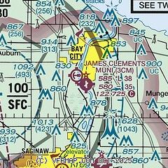
|
| Airport distance calculator |
|---|
|
|
| Sunrise and sunset |
|---|
|
Times for 15-Jul-2026
| | Local
(UTC-4) | | Zulu
(UTC) |
|---|
| Morning civil twilight | | 05:35 | | 09:35 |
| Sunrise | | 06:09 | | 10:09 |
| Sunset | | 21:14 | | 01:14 |
| Evening civil twilight | | 21:48 | | 01:48 |
|
| Current date and time |
|---|
| Zulu (UTC) | 15-Jul-2026 12:30:25 |
|---|
| Local (UTC-4) | 15-Jul-2026 08:30:25 |
|---|
|
| METAR |
|---|
KHYX
7nm S | 151215Z AUTO 30007KT 10SM CLR 26/21 A3003 RMK AO2
|
KMBS
8nm W | 151153Z 28005KT 10SM CLR 24/21 A3004 RMK AO2 SLP168 T02440211 10244 20211 51005
|
|
| TAF |
|---|
KMBS
8nm W | 151120Z 1512/1612 24006KT P6SM SCT250 FM151600 33006KT 5SM FU BKN200 FM160000 01005KT 4SM FU BKN200
|
|
| NOTAMs |
|---|
NOTAMs are issued by the DoD/FAA and will open in a separate window not controlled by AirNav.
|
|

