FAA INFORMATION EFFECTIVE 27 NOVEMBER 2025
Location
| FAA Identifier: | 3TX |
| Lat/Long: | 33-23-34.2623N 097-21-13.8500W
33-23.571038N 097-21.230833W
33.3928506,-97.3538472
(estimated) |
| Elevation: | 895 ft. / 273 m (estimated) |
| From city: | 3 miles NE of SLIDELL, TX |
| Time zone: | UTC -6 (UTC -5 during Daylight Saving Time) |
| Zip code: | 76238 |
Airport Operations
| Airport use: | Open to the public |
| Activation date: | 03/2005 |
| Control tower: | no |
| ARTCC: | FORT WORTH CENTER |
| FSS: | FORT WORTH FLIGHT SERVICE STATION |
| NOTAMs facility: | 3TX (NOTAM-D service available) |
| Attendance: | IREG |
| Wind indicator: | yes |
| Segmented circle: | no |
Airport Communications
| CTAF: | 122.9 |
| WX ASOS at DTO (14 nm SE): | 119.325 (940-383-8457) |
| WX AWOS-3 at LUD (14 nm SW): | 118.225 (940-627-2365) |
| WX AWOS-3 at GLE (17 nm NE): | 118.375 (940-612-3549) |
Nearby radio navigation aids
| VOR radial/distance | | VOR name | | Freq | | Var |
|---|
| UKWr104/24.9 | | BOWIE VORTAC | | 117.15 | | 06E |
| FUZr338/31.4 | | RANGER VORTAC | | 115.70 | | 06E |
| TTTr327/35.1 | | MAVERICK VOR/DME | | 113.10 | | 06E |
| CVEr317/37.7 | | COWBOY VOR/DME | | 116.20 | | 06E |
| NDB name | | Hdg/Dist | | Freq | | Var | | ID |
|---|
| PINCK | | 306/10.3 | | 257 | | 04E | | DT | -.. - |
Airport Services
Runway Information
Runway 18/36
| Dimensions: | 3001 x 60 ft. / 915 x 18 m |
| Surface: | turf, in good condition |
| Runway edge markings: | RWY 18/36 CORNERS MKD WITH WHITE BARRELS. |
| RUNWAY 18 | | RUNWAY 36 |
| Latitude: | 33-23.809167N | | 33-23.316333N |
| Longitude: | 097-21.236167W | | 097-21.289833W |
| Elevation: | 880.0 ft. | | 878.0 ft. |
| Traffic pattern: | left | | left |
| Obstructions: | 4 ft. fence, 117 ft. right of centerline, 1:1 slope to clear | | 10 ft. road, 90 ft. left of centerline, 1:1 slope to clear |
Runway 5/23
| Dimensions: | 1600 x 60 ft. / 488 x 18 m |
| Surface: | turf, in good condition |
| Runway edge markings: | RWY 05/23 CORNERS MKD WITH WHITE BARRELS.. |
| RUNWAY 5 | | RUNWAY 23 |
| Latitude: | 33-23.514833N | | 33-23.658333N |
| Longitude: | 097-21.302500W | | 097-21.038500W |
| Elevation: | 882.0 ft. | | 882.0 ft. |
| Traffic pattern: | left | | left |
| Obstructions: | 4 ft. fence, 90 ft. left of centerline, 1:1 slope to clear | | 4 ft. fence, 121 ft. left and right of centerline, 1:1 slope to clear |
Airport Ownership and Management from official FAA records
| Ownership: | Privately-owned |
| Owner: | JULIA A. & TONY L. WOOD
PO BOX 9
SLIDELL, TX 76267
Phone 817-658-4569 |
| Manager: | JULIA & TONY WOOD
PO BOX 9
SLIDELL, TX 76267
Phone 817-658-4569 |
Additional Remarks
| - | APA ACROBATIC PRACTICE AREA CO-LCTD WITH THIS ARPT. INTSV AEROBATIC TRNG. PPR. CTC AMGR 24 HRS PRIOR TO ARR, 817-658-7479. |
| - | BIRDS, COWS AND WILDLIFE INVOF RWYS. |
| - | RADIO CTC RECOMMENDED PRIOR TO LDG FOR ADZY. |
| - | FOR CD CTC REGIONAL APCH AT 972-615-2799. |
| - | PPR. CTC AMGR 24 HRS PRIOR TO ARR, 817-658-7479 FOR FLD CONDS. |
| - | ARPT FENCED & GATE LOCKED. FOR INGRESS & EGRESS, CALL 817-658-7479. |
| - | ARPT ROLLING TRRN. ACFT NOT VSB AT OPPOSITE RWY ENDS. |
| - | LOOSE ROCKS ON RWY. CALL FOR FICONS. |
Instrument Procedures
There are no published instrument procedures at 3TX.
Some nearby airports with instrument procedures:
KDTO - Denton Enterprise Airport (14 nm SE)
KLUD - Decatur Municipal Airport (14 nm SW)
KGLE - Gainesville Municipal Airport (17 nm NE)
KAFW - Perot Field/Fort Worth Alliance Airport (24 nm S)
0F2 - Bowie Municipal Airport (25 nm NW)
|
|

Road maps at:
MapQuest
Bing
Google
| Aerial photo |
|---|
WARNING: Photo may not be current or correct
 Photo by Julia Wood
Taken in May 2005
Photo by Julia Wood
Taken in May 2005
Do you have a better or more recent aerial photo of Akroville Airport that you would like to share? If so, please send us your photo.
|
| Sectional chart |
|---|
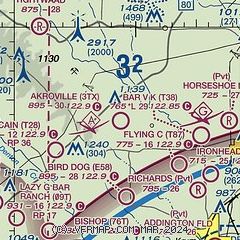
|
| Airport distance calculator |
|---|
|
|
| Sunrise and sunset |
|---|
|
Times for 04-Dec-2025
| | Local
(UTC-6) | | Zulu
(UTC) |
|---|
| Morning civil twilight | | 06:52 | | 12:52 |
| Sunrise | | 07:19 | | 13:19 |
| Sunset | | 17:21 | | 23:21 |
| Evening civil twilight | | 17:48 | | 23:48 |
|
| Current date and time |
|---|
| Zulu (UTC) | 05-Dec-2025 03:44:44 |
|---|
| Local (UTC-6) | 04-Dec-2025 21:44:44 |
|---|
|
| METAR |
|---|
KDTO
14nm SE | 050313Z 00000KT 10SM SCT014 OVC034 04/02 A3023 RMK AO2 T00390022
|
KLUD
14nm SW | 118.22 940-927-2365
050335Z AUTO 00000KT 7SM OVC010 03/01 A3022 RMK AO2 T00300006
|
K0F2
25nm NW | 040910Z AUTO 03009KT 10SM OVC041 04/00 A3020 RMK AO2 T00400001
|
KAFW
26nm S | 050327Z 00000KT 10SM OVC015 04/01 A3022 RMK AO2 T00440011
|
KXBP
27nm SW | 050335Z AUTO 27004KT 10SM OVC012 04/01 A3025 RMK AO2 T00360010
|
|
| TAF |
|---|
KAFW
26nm S | 042057Z 0421/0518 35011KT P6SM OVC018 FM050900 32005KT P6SM SCT025 OVC250 FM051000 18005KT P6SM BKN250
|
|
| NOTAMs |
|---|
NOTAMs are issued by the DoD/FAA and will open in a separate window not controlled by AirNav.
|
|


