FAA INFORMATION EFFECTIVE 12 JUNE 2025
Location
| FAA Identifier: | 3VS |
| Lat/Long: | 38-25-41.7800N 092-52-30.9500W
38-25.696333N 092-52.515833W
38.4282722,-92.8752639
(estimated) |
| Elevation: | 1027 ft. / 313 m (estimated) |
| Variation: | 04E (1985) |
| From city: | 2 miles W of VERSAILLES, MO |
| Time zone: | UTC -5 (UTC -6 during Standard Time) |
| Zip code: | 65084 |
Airport Operations
| Airport use: | Open to the public |
| Activation date: | 03/1971 |
| Control tower: | no |
| ARTCC: | KANSAS CITY CENTER |
| FSS: | COLUMBIA FLIGHT SERVICE STATION |
| NOTAMs facility: | COU (NOTAM-D service available) |
| Attendance: | 0800-1700 |
| Wind indicator: | lighted |
| Segmented circle: | yes |
| Lights: | ACTVT MIRL RY 07/25 - CTAF, CLICK 3 TIMES. |
| Beacon: | white-green (lighted land airport)
Operates sunset to sunrise. |
Airport Communications
Nearby radio navigation aids
| VOR radial/distance | | VOR name | | Freq | | Var |
|---|
| SHYr331/26.6 | | SUNSHINE VOR/DME | | 108.40 | | 00E |
| COUr233/38.4 | | COLUMBIA VOR/DME | | 110.20 | | 00E |
Airport Services
| Fuel available: | 100LL
100LL:FUEL AVBL 24 HRS SELF-SVC. |
| Parking: | tiedowns |
| Airframe service: | NONE |
| Powerplant service: | NONE |
| Bottled oxygen: | NONE |
| Bulk oxygen: | NONE |
Runway Information
Runway 7/25
| Dimensions: | 2805 x 39 ft. / 855 x 12 m
WIDTH VARIANCE 39-40 FT. |
| Surface: | asphalt, in good condition |
| Runway edge lights: | medium intensity |
| RUNWAY 7 | | RUNWAY 25 |
| Latitude: | 38-25.627500N | | 38-25.765167N |
| Longitude: | 092-52.796333W | | 092-52.235333W |
| Elevation: | 1027.0 ft. | | 1003.0 ft. |
| Traffic pattern: | left | | right |
| Markings: | basic, in good condition | | basic, in good condition |
| Obstructions: | 63 ft. trees, 631 ft. from runway, 87 ft. right of centerline, 6:1 slope to clear | | 77 ft. trees, 1145 ft. from runway, 225 ft. left and right of centerline, 12:1 slope to clear
8 FT ROAD 105-200 FT FM RWY END 40-125L; |
Helipad H1
| Dimensions: | 50 x 50 ft. / 15 x 15 m |
| Surface: | concrete, in good condition |
| Runway edge lights: | PERI |
| Latitude: | 38-25.714667N | | |
| Longitude: | 092-52.282167W | | |
| Elevation: | 1010.0 ft. | | |
| Traffic pattern: | left | | left |
| Markings: | basic, in good condition | | |
Airport Ownership and Management from official FAA records
| Ownership: | Publicly-owned |
| Owner: | CITY OF VERSAILLES
104 N. FISHER ST.
VERSAILLES, MO 65084
Phone 573-378-4634 |
| Manager: | JAMIE MORROW
104 N. FISHER ST, 10998 HIGHWAY 52
VERSAILLES, MO 65084
Phone 573-378-4634
AFTER HOURS NON-EMERGENCY: 573-378-0623 |
Additional Remarks
| - | CROP DUSTING ACFT AND HELICOPTERS; AND ULTRALIGHT ACTIVITY ON AND INVOF ARPT. |
| - | DEER & WILDLIFE ON & INVOF ARPT. |
| - | RY 07/25 LINE OF SIGHT OBSTRUCTED BY GRADE CHANGE IN RY. |
| - | NTSD RY SAFETY AREA BYND EACH RY END; INCORRECT TERRAIN GRADES, LARGE DROP OFF AT RY 07 END, ROAD AT RY 25 END. |
| - | FOR CD CTC WHITEMAN APCH AT 660-687-3132. WHEN WHITEMAN APCH IS CLSD, CTC KANSAS CITY ARTCC AT 913-254-8508. |
Instrument Procedures
There are no published instrument procedures at 3VS.
Some nearby airports with instrument procedures:
H79 - Eldon Model Airpark (15 nm E)
K15 - Grand Glaize-Osage Beach Airport (21 nm SE)
KDMO - Sedalia Regional Airport (22 nm NW)
KRAW - Warsaw Municipal Airport (23 nm W)
KAIZ - Lee C Fine Memorial Airport (25 nm SE)
|
|

Road maps at:
MapQuest
Bing
Google
| Aerial photo |
|---|
WARNING: Photo may not be current or correct

Do you have a better or more recent aerial photo of Roy Otten Memorial Airfield that you would like to share? If so, please send us your photo.
|
| Sectional chart |
|---|
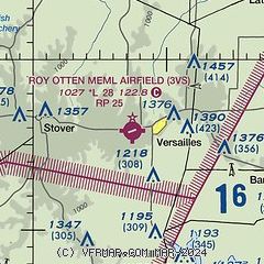
|
| Airport distance calculator |
|---|
|
|
| Sunrise and sunset |
|---|
|
Times for 02-Jul-2025
| | Local
(UTC-5) | | Zulu
(UTC) |
|---|
| Morning civil twilight | | 05:21 | | 10:21 |
| Sunrise | | 05:53 | | 10:53 |
| Sunset | | 20:38 | | 01:38 |
| Evening civil twilight | | 21:10 | | 02:10 |
|
| Current date and time |
|---|
| Zulu (UTC) | 02-Jul-2025 21:40:46 |
|---|
| Local (UTC-5) | 02-Jul-2025 16:40:46 |
|---|
|
| METAR |
|---|
KDMO
22nm NW | 022053Z AUTO 22004KT 10SM SCT055 BKN070 29/17 A3004 RMK AO2 SLP164 T02940172 56013
|
KAIZ
25nm SE | 022056Z AUTO 24006KT 10SM CLR 30/17 A3005 RMK AO2 SLP165 T03000167 58012
|
KOZS
29nm S | 022115Z AUTO 31003KT 10SM CLR 29/13 A3005 RMK AO2
|
KVER
32nm N | 022115Z AUTO 23003KT 10SM SCT060 SCT070 A3002 RMK AO2
|
KSZL
35nm NW | 021955Z 21009KT 10SM BKN050 BKN065 BKN150 31/19 A3003 RMK AO2A SLP164 T03130186 57014 VISNO RWY01 $
|
KJEF
36nm E | 022053Z 23006KT 10SM BKN065 32/16 A3001 RMK AO2 SLP148 T03170161 56014 $
|
KGLY
38nm W | 022115Z AUTO 21004KT 10SM CLR 30/18 A3002 RMK AO2
|
KCOU
39nm NE | 022054Z 24005KT 10SM SCT060 29/17 A3004 RMK AO2 SLP162 T02940167 56012 $
|
KMHL
43nm N | 022115Z AUTO 21005KT 10SM CLR 29/18 A3002 RMK AO2
|
|
| TAF |
|---|
KSZL
35nm NW | 021100Z 0211/0317 20009KT 9999 FEW060 QNH3000INS TX31/0221Z TN19/0211Z
|
KJEF
36nm E | 021720Z 0218/0318 VRB05KT P6SM SCT060
|
KCOU
39nm NE | 021720Z 0218/0318 24005KT P6SM SCT050 FM030200 21004KT P6SM FEW060 FEW250
|
|
| NOTAMs |
|---|
NOTAMs are issued by the DoD/FAA and will open in a separate window not controlled by AirNav.
|
|


