FAA INFORMATION EFFECTIVE 09 JULY 2026
Location
| FAA Identifier: | 4MB |
| Lat/Long: | 43-46-02.8453N 071-23-15.4542W
43-46.047422N 071-23.257570W
43.7674570,-71.3876262
(estimated) |
| Elevation: | 576 ft. / 176 m (estimated) |
| Variation: | 16W (1985) |
| From city: | 1 mile NE of MOULTONBOROUGH, NH
(15MI N LACONIA.) |
| Time zone: | UTC -4 (UTC -5 during Standard Time) |
| Zip code: | 03254 |
Airport Operations
| Airport use: | Open to the public |
| Activation date: | 09/1973 |
| Control tower: | no |
| ARTCC: | BOSTON CENTER |
| FSS: | BANGOR FLIGHT SERVICE STATION |
| NOTAMs facility: | BGR (NOTAM-D service available) |
| Attendance: | MAY-OCT MON-FRI IREG, MAY-OCT SAT-SUN IREG, OCT-MAY APPOINTMENT |
| Wind indicator: | yes, CONT LGTD DUSK-DAWN. |
| Segmented circle: | no |
| Lights: | ACTVT NON-STD LIRL RWY 02/20 - CTAF. 5 CLICKS ON & 3 CLICKS OFF. |
| Beacon: | white-green (lighted land airport)
ACTVT ROTG BCN - CTAF. 5 CLICKS ON, 3 CLICKS OFF. |
Airport Communications
| CTAF/UNICOM: | 122.8 |
| WX AWOS-3PT at LCI (12 nm S): | 133.525 (603-524-5134) |
| WX AWOS-3 at 1P1 (16 nm W): | 118.45 (603-536-1698) |
Nearby radio navigation aids
| VOR radial/distance | | VOR name | | Freq | | Var |
|---|
| CONr029/33.9 | | CONCORD VOR/DME | | 112.90 | | 15W |
| ENEr318/39.4 | | KENNEBUNK VOR/DME | | 117.10 | | 17W |
| NDB name | | Hdg/Dist | | Freq | | Var | | ID |
|---|
| HANOVER | | 098/34.5 | | 276 | | 15W | | LAH | .-.. .- .... |
| MAHN | | 177/37.9 | | 386 | | 17W | | GMA | --. -- .- |
Airport Services
| Fuel available: | 100LL
100LL:24 HR SELF SVC FUEL AVBL WITH CREDIT CARD. |
| Parking: | hangars and tiedowns |
| Airframe service: | MAJOR |
| Powerplant service: | MAJOR |
| Bottled oxygen: | NONE |
| Bulk oxygen: | NONE |
Runway Information
Runway 2/20
| Dimensions: | 3505 x 50 ft. / 1068 x 15 m |
| Surface: | asphalt, in fair condition |
| Weight bearing capacity: | |
| Runway edge lights: | non-standard
RWY 02/20 NON-STD LIRL, LGTS ARE 4 FT HIGH. LGTD ONLY BTN DTHR, VRB SPACING, 2890 FT OF RWY LGTD. |
| Runway edge markings: | RWY 2/20 NON-STD CNTRLN SIZE & SPACING. DTHR NOT MKD. |
| RUNWAY 2 | | RUNWAY 20 |
| Latitude: | 43-45.759817N | | 43-46.335027N |
| Longitude: | 071-23.287698W | | 071-23.227440W |
| Elevation: | 572.0 ft. | | 576.0 ft. |
| Traffic pattern: | left | | left |
| Runway heading: | 020 magnetic, 004 true | | 200 magnetic, 184 true |
| Markings: | NSTD, in fair condition | | NSTD, in fair condition |
| Runway end identifier lights: | no | | no |
| Touchdown point: | yes, no lights | | yes, no lights |
| Obstructions: | 79 ft. trees, 616 ft. from runway, 153 ft. right of centerline, 5:1 slope to clear
APCH SLOPE 15:1 TO DTHR. CTLG OBSTN EXCEEDS A 45 DEG SLP. | | 46 ft. trees, 214 ft. from runway, 53 ft. left of centerline |
Airport Ownership and Management from official FAA records
| Ownership: | Privately-owned |
| Owner: | NORTH COUNTRY AIR BASE, LLC
39 AIRPORT RD
MOULTONBOROUGH, NH 03254
Phone 603-636-7310 |
| Manager: | JOHN ST. AMAND
39 AIRPORT RD
MOULTONBOROUGH, NH 03254
Phone 508-479-8301 |
Additional Remarks
| - | RWY 2 PLINE MKRS FADED. |
| - | WILDLIFE ON & INVOF ARPT. |
| - | NMRS NON-RADIO EQUIPPED ACFT OPRG FM AIRFLD. |
| - | RWY 2 DESIGNATED CALM WIND RWY. |
| - | COURTESY CAR AVBL ON REQ. |
| - | FLOAT PLANE ACCESS TO & FM BERRY POND. |
| - | FOR CD CTC BOSTON ARTCC AT 603-879-8659. |
| - | OVERFLY RWY TO CHECK FOR WILDLIFE. |
Instrument Procedures
There are no published instrument procedures at 4MB.
Some nearby airports with instrument procedures:
KLCI - Laconia Municipal Airport (12 nm S)
KIZG - White Mountain Regional Airport (23 nm NE)
5B9 - Dean Memorial Airport (33 nm NW)
KCON - Concord Municipal Airport (34 nm S)
KDAW - Skyhaven Airport (35 nm SE)
|
|

Road maps at:
MapQuest
Bing
Google
| Aerial photo |
|---|
WARNING: Photo may not be current or correct
 Photo by Steven F. Hyde, Skyhaven Flying Club
Photo taken 07-Jun-2011
looking northwest.
Photo by Steven F. Hyde, Skyhaven Flying Club
Photo taken 07-Jun-2011
looking northwest.
Do you have a better or more recent aerial photo of Moultonborough Airport that you would like to share? If so, please send us your photo.
|
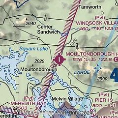
| Sectional chart |
|---|
|
| Airport distance calculator |
|---|
|
|
| Sunrise and sunset |
|---|
|
Times for 03-Aug-2026
| | Local
(UTC-4) | | Zulu
(UTC) |
|---|
| Morning civil twilight | | 05:05 | | 09:05 |
| Sunrise | | 05:37 | | 09:37 |
| Sunset | | 20:06 | | 00:06 |
| Evening civil twilight | | 20:38 | | 00:38 |
|
| Current date and time |
|---|
| Zulu (UTC) | 03-Aug-2026 11:47:07 |
|---|
| Local (UTC-4) | 03-Aug-2026 07:47:07 |
|---|
|
| METAR |
|---|
KLCI
12nm S | 031134Z AUTO 00000KT 10SM -RA FEW003 BKN035 OVC043 22/21 A2975 RMK AO2 P0000
|
K1P1
16nm W | 031135Z AUTO 00000KT 10SM OVC006 21/20 A2974 RMK AO2 T02070200
|
KIZG
23nm NE | 031140Z AUTO 00000KT 6SM -RA BR SCT004 BKN017 OVC022 21/20 A2977 RMK AO2 P0033 T02110200 $
|
|
| TAF |
|---|
KCON
34nm S | 030945Z 0310/0406 12007KT 3SM RA BR BKN007 OVC012 FM031700 18009KT 5SM SHRA BR BKN008 FM032100 23013G23KT 6SM -SHRA OVC015 FM032300 25011G20KT P6SM BKN090
|
KHIE
37nm N | 030945Z 0310/0406 28004KT P6SM -RA SCT040 BKN060 OVC080 FM031100 00000KT 5SM BR OVC025 FM031200 12005KT 2SM SHRA BR OVC008 FM031600 18007KT 5SM BR BKN015 FM040000 25014G25KT P6SM BKN025
|
KLEB
40nm W | 030945Z 0310/0406 00000KT 2SM -RA BR FEW001 OVC018 FM031500 19006KT 3SM -SHRA BR BKN008 FM031700 19010G20KT 6SM -SHRA BR BKN015 FM032100 22011G22KT P6SM BKN025
|
|
| NOTAMs |
|---|
NOTAMs are issued by the DoD/FAA and will open in a separate window not controlled by AirNav.
|
|

