FAA INFORMATION EFFECTIVE 09 JULY 2026
Location
| FAA Identifier: | 5C8 |
| Lat/Long: | 47-21-04.1360N 101-01-33.2260W
47-21.068933N 101-01.553767W
47.3511489,-101.0258961
(estimated) |
| Elevation: | 1908 ft. / 581.6 m (surveyed) |
| Variation: | 10E (1985) |
| From city: | 4 miles N of WASHBURN, ND |
| Time zone: | UTC -5 (UTC -6 during Standard Time) |
| Zip code: | 58577 |
Airport Operations
| Airport use: | Open to the public |
| Activation date: | 12/1943 |
| Control tower: | no |
| ARTCC: | MINNEAPOLIS CENTER |
| FSS: | GRAND FORKS FLIGHT SERVICE STATION |
| NOTAMs facility: | GFK (NOTAM-D service available) |
| Attendance: | UNATNDD |
| Wind indicator: | lighted |
| Segmented circle: | yes |
| Lights: | ACTVT MIRL RY 08/26 & PAPI RY 8/26 - CTAF. LOW INTST NOT AVBL. |
| Beacon: | white-green (lighted land airport)
Operates sunset to sunrise. |
Airport Communications
- APCH/DEP SVC PRVDD BY MINNEAPOLIS ARTCC (ZMP) ON FREQS 127.6/279.6 (MINOT RCAG).
Nearby radio navigation aids
| VOR radial/distance | | VOR name | | Freq | | Var |
|---|
| BISr325/38.3 | | BISMARCK VOR/DME | | 115.65 | | 12E |
Airport Services
| Fuel available: | 100LL
100LL:24HR SELF-SERVICE FUEL AVBL WITH CREDIT CARD. |
| Parking: | tiedowns |
| Airframe service: | NONE |
| Powerplant service: | NONE |
| Bottled oxygen: | NONE |
| Bulk oxygen: | NONE |
Runway Information
Runway 8/26
| Dimensions: | 3700 x 60 ft. / 1128 x 18 m |
| Surface: | concrete, in good condition |
| Runway edge lights: | medium intensity |
| RUNWAY 8 | | RUNWAY 26 |
| Latitude: | 47-21.005825N | | 47-21.004792N |
| Longitude: | 101-02.022315W | | 101-01.126860W |
| Elevation: | 1907.0 ft. | | 1907.4 ft. |
| Traffic pattern: | left | | left |
| Runway heading: | 080 magnetic, 090 true | | 260 magnetic, 270 true |
| Markings: | nonprecision, in good condition | | nonprecision, in good condition |
| Visual slope indicator: | 2-light PAPI on left (3.00 degrees glide path) | | 2-light PAPI on left (3.00 degrees glide path) |
| Touchdown point: | yes, no lights | | yes, no lights |
Runway 17/35
| Dimensions: | 2204 x 135 ft. / 672 x 41 m |
| Surface: | turf, in good condition |
| Runway edge markings: | MKD WITH DALGT BOUNDARY MARKERS; BLACK/WHITE CONES. |
| Operational restrictions: | CLSD WINTER MONTHS DUE TO LACK OF SNOW REMOVAL. |
| RUNWAY 17 | | RUNWAY 35 |
| Latitude: | 47-21.356988N | | 47-20.994508N |
| Longitude: | 101-01.518203W | | 101-01.519457W |
| Elevation: | 1903.9 ft. | | 1906.4 ft. |
| Traffic pattern: | left | | left |
| Runway heading: | 170 magnetic, 180 true | | 350 magnetic, 000 true |
| Markings: | NSTD | | NSTD |
| Runway end identifier lights: | no | | no |
| Touchdown point: | yes, no lights | | yes, no lights |
Airport Ownership and Management from official FAA records
| Ownership: | Publicly-owned |
| Owner: | WASHBURN AIRPORT AUTHORITY
BOX 403
WASHBURN, ND 58577
Phone 701-460-0196 |
| Manager: | DON ROBINSON
BOX 403
WASHBURN, ND 58577
Phone 701-460-0196 |
Additional Remarks
| A52-35 | +150 FT EAST-WEST TRANSMISSION LINE 9500' SOUTH ON EXTNDD CNTRLN. |
| - | +700' SMOKE STACK OF POWER PLANT LOCATED 6 MI WNW OF ARPT. |
| - | WATERFOWL, BLACKBIRDS, DEER, & ANTELOPE ON AND INVOF OF ARPT. |
| - | CONFIRM WINTER CONDITIONS WITH ARPT MGR AFTER MAJOR STORM PRIOR TO USE - SNOW REMOVAL IRREGULAR SCHEDULE. |
| - | FOR CD CTC MINNEAPOLIS ARTCC AT 651-463-5588. |
Instrument Procedures
NOTE: All procedures below are presented as PDF files. If you need a reader for these files, you should download the free Adobe Reader.NOT FOR NAVIGATION. Please procure official charts for flight.
FAA instrument procedures published for use from 09 July 2026 at 0901Z to 06 August 2026 at 0900Z.
IAPs - Instrument Approach Procedures |
|---|
| RNAV (GPS) RWY 08 | |
download (251KB) |
| RNAV (GPS) RWY 26 | |
download (251KB) |
| NOTE: Special Take-Off Minimums/Departure Procedures apply | |
download (443KB) |
Other nearby airports with instrument procedures:
KHZE - Mercer County Regional Airport (23 nm W)
D05 - Garrison Municipal Airport (25 nm NW)
Y19 - Mandan Regional Airport/Lawler Field (35 nm S)
KBIS - Bismarck Municipal Airport (37 nm S)
D57 - Glen Ullin Regional Airport (47 nm SW)
|
|

Road maps at:
MapQuest
Bing
Google
| Aerial photo |
|---|
WARNING: Photo may not be current or correct

Do you have a better or more recent aerial photo of Washburn Municipal Airport that you would like to share? If so, please send us your photo.
|
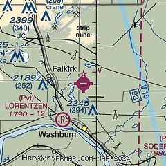
| Sectional chart |
|---|
|
| Airport distance calculator |
|---|
|
|
| Sunrise and sunset |
|---|
|
Times for 21-Jul-2026
| | Local
(UTC-5) | | Zulu
(UTC) |
|---|
| Morning civil twilight | | 05:33 | | 10:33 |
| Sunrise | | 06:10 | | 11:10 |
| Sunset | | 21:31 | | 02:31 |
| Evening civil twilight | | 22:08 | | 03:08 |
|
| Current date and time |
|---|
| Zulu (UTC) | 21-Jul-2026 17:07:09 |
|---|
| Local (UTC-5) | 21-Jul-2026 12:07:09 |
|---|
|
| METAR |
|---|
KHZE
23nm W | 211655Z AUTO VRB05KT 10SM FEW033 22/09 A3022 RMK AO2
|
KN60
24nm NW | 211654Z AUTO VRB05KT 21/11 A3020 RMK AO1 SLP223 T02110111
|
KY19
35nm S | 211655Z AUTO 03008KT 10SM SCT035 BKN041 22/15 A3021 RMK AO2
|
KBIS
37nm S | 211652Z 32006KT 10SM SCT039 23/11 A3020 RMK AO2 SLP219 T02330111
|
|
| TAF |
|---|
KBIS
37nm S | 211123Z 2112/2212 34009KT P6SM FEW200 FM211500 36009KT P6SM FEW060 SCT180 FM220300 05005KT P6SM FEW060 FEW180 FM220600 VRB03KT P6SM FEW080
|
|
| NOTAMs |
|---|
NOTAMs are issued by the DoD/FAA and will open in a separate window not controlled by AirNav.
|
|

