FAA INFORMATION EFFECTIVE 09 JULY 2026
Location
| FAA Identifier: | Y19 |
| Lat/Long: | 46-46-04.7000N 100-53-39.7000W
46-46.078333N 100-53.661667W
46.7679722,-100.8943611
(estimated) |
| Elevation: | 1944 ft. / 592.5 m (surveyed) |
| Variation: | 06E (2015) |
| From city: | 4 miles S of MANDAN, ND |
| Time zone: | UTC -5 (UTC -6 during Standard Time) |
| Zip code: | 58554 |
Airport Operations
| Airport use: | Open to the public |
| Activation date: | 10/1949 |
| Control tower: | no |
| ARTCC: | MINNEAPOLIS CENTER |
| FSS: | GRAND FORKS FLIGHT SERVICE STATION |
| NOTAMs facility: | GFK (NOTAM-D service available) |
| Attendance: | MON-FRI 0700-1900, ALL SAT-SUN ON CALL |
| Wind indicator: | lighted |
| Segmented circle: | yes |
| Lights: | MIRL RY 13/31 & RY 04/22 PRESET ON MED TO INCR INTST & ACTVT - CTAF; ACTVT REIL RY 13/31; & PAPI RY 13/31 - CTAF. |
| Beacon: | white-green (lighted land airport)
Operates sunset to sunrise. |
Airport Communications
| CTAF/UNICOM: | 122.8 |
| WX AWOS-3: | 118.225 (701-663-0271) |
| BISMARCK APPROACH: | 126.3 [1200-0530Z++; CLSD HOL. OT CTC MINNEAPOLIS CENTER.] |
| BISMARCK DEPARTURE: | 126.3 [1200-0530Z++; CLSD HOL. OT CTC MINNEAPOLIS CENTER.] |
| WX ASOS at BIS (6 nm E): | PHONE 701-922-9747 |
- APCH/DEP SVC PRVDD BY MINNEAPOLIS ARTCC ON FREQS 135.25/256.7 (WOODWORTH RCAG) WHEN BISMARCK APCH CTL CLSD.
Nearby radio navigation aids
| VOR radial/distance | | VOR name | | Freq | | Var |
|---|
| BISr260/9.4 | | BISMARCK VOR/DME | | 115.65 | | 12E |
Airport Services
| Fuel available: | 100LL
100LL:FOR 100LL FUEL 24 HR SELF SVC WITH CREDIT CARD OR CALL AMGR CELL PHONE 701-955-3328. |
| Parking: | hangars and tiedowns |
| Airframe service: | MAJOR |
| Powerplant service: | MAJOR |
Runway Information
Runway 13/31
| Dimensions: | 4399 x 75 ft. / 1341 x 23 m |
| Surface: | concrete, in good condition |
| Weight bearing capacity: | |
| Runway edge lights: | medium intensity |
| RUNWAY 13 | | RUNWAY 31 |
| Latitude: | 46-46.420973N | | 46-45.826200N |
| Longitude: | 100-53.946158W | | 100-53.346137W |
| Elevation: | 1942.0 ft. | | 1943.0 ft. |
| Traffic pattern: | left | | left |
| Runway heading: | 139 magnetic, 145 true | | 319 magnetic, 325 true |
| Markings: | nonprecision, in good condition | | nonprecision, in good condition |
| Visual slope indicator: | 2-light PAPI on left (3.00 degrees glide path) | | 2-light PAPI on left (3.00 degrees glide path) |
| Runway end identifier lights: | yes | | yes |
| Touchdown point: | yes, no lights | | yes, no lights |
Runway 4/22
| Dimensions: | 2921 x 140 ft. / 890 x 43 m |
| Surface: | turf, in good condition |
| Runway edge lights: | medium intensity |
| RUNWAY 4 | | RUNWAY 22 |
| Latitude: | 46-45.874090N | | 46-46.147857N |
| Longitude: | 100-53.971152W | | 100-53.396620W |
| Elevation: | 1924.2 ft. | | 1943.4 ft. |
| Traffic pattern: | left | | left |
| Runway heading: | 049 magnetic, 055 true | | 229 magnetic, 235 true |
| Touchdown point: | yes, no lights | | yes, no lights |
Airport Ownership and Management from official FAA records
| Ownership: | Publicly-owned |
| Owner: | MANDAN ARPT AUTHORITY
BOX 250
MANDAN, ND 58554
Phone 701-663-0669 |
| Manager: | LINDSAY GERHARDT
BOX 250
MANDAN, ND 58554
Phone 701-663-0669
AMGR CELL PHONE 701-955-3328. |
Additional Remarks
| A57-13 | RWY 13 44 FT TREES 1250 FT FR THR APCH RATIO 23:1. |
| A57-04 | RWY 4 10 FT FENCE 366 FT FR THR APCH RATIO 26:1; ROAD 480 FT FR RWY 4 THR APCH RATIO 28:1. |
| - | CFM SN REMOVAL AFT MAJOR WINT STORMS WITH AMGR 701-663-0669 OR 701-955-3328. |
| - | +200 FT TWR LCTD 9500 FT NW OF RWY 13/31. |
| - | 120 FT TWR LCTD 5000 FT SW OF RWY 04/22. |
| - | FOR CD CTC BISMARCK APCH AT 701-223-8790. |
Instrument Procedures
NOTE: All procedures below are presented as PDF files. If you need a reader for these files, you should download the free Adobe Reader.NOT FOR NAVIGATION. Please procure official charts for flight.
FAA instrument procedures published for use from 09 July 2026 at 0901Z to 06 August 2026 at 0900Z.
IAPs - Instrument Approach Procedures |
|---|
| RNAV (GPS) RWY 13 **CHANGED** | |
download (253KB) |
| RNAV (GPS) RWY 31 **CHANGED** | |
download (254KB) |
| VOR-A **CHANGED** | |
download (207KB) |
| Radar Approach Procedures available | |
download (144KB) |
| NOTE: Special Alternate Minimums apply | |
download (153KB) |
| NOTE: Special Take-Off Minimums/Departure Procedures apply | |
download (398KB) |
Other nearby airports with instrument procedures:
KBIS - Bismarck Municipal Airport (6 nm E)
5C8 - Washburn Municipal Airport (35 nm N)
D57 - Glen Ullin Regional Airport (40 nm W)
KHZE - Mercer County Regional Airport (42 nm NW)
7L2 - Linton Municipal Airport (42 nm SE)
|
|

Road maps at:
MapQuest
Bing
Google
| Aerial photo |
|---|
WARNING: Photo may not be current or correct
 Looking east.
Do you have a better or more recent aerial photo of Mandan Regional Airport/Lawler Field that you would like to share? If so, please send us your photo.
|
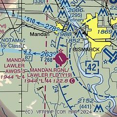
| Sectional chart |
|---|
|
| Airport distance calculator |
|---|
|
|
| Sunrise and sunset |
|---|
|
Times for 12-Jul-2026
| | Local
(UTC-5) | | Zulu
(UTC) |
|---|
| Morning civil twilight | | 05:25 | | 10:25 |
| Sunrise | | 06:03 | | 11:03 |
| Sunset | | 21:35 | | 02:35 |
| Evening civil twilight | | 22:14 | | 03:14 |
|
| Current date and time |
|---|
| Zulu (UTC) | 12-Jul-2026 17:55:18 |
|---|
| Local (UTC-5) | 12-Jul-2026 12:55:18 |
|---|
|
| METAR |
|---|
| KY19 | 121735Z AUTO 19011G18KT 10SM CLR 33/24 A3002 RMK AO2
|
KBIS
6nm E | 121652Z 18007KT 10SM CLR 33/20 A3000 RMK AO2 SLP146 T03330200
|
|
| TAF |
|---|
KBIS
6nm E | 121128Z 1212/1312 13005KT P6SM SKC FM121500 18010KT P6SM SKC FM121800 18014G24KT P6SM SKC FM130200 16013KT P6SM SKC FM130500 17014KT P6SM SKC WS010/20040KT
|
|
| NOTAMs |
|---|
NOTAMs are issued by the DoD/FAA and will open in a separate window not controlled by AirNav.
|
|


