FAA INFORMATION EFFECTIVE 27 NOVEMBER 2025
Location
| FAA Identifier: | 5F1 |
| Lat/Long: | 33-12-11.9000N 101-20-17.6000W
33-12.198333N 101-20.293333W
33.2033056,-101.3382222
(estimated) |
| Elevation: | 2545 ft. / 775.7 m (surveyed) |
| Variation: | 11E (1985) |
| From city: | 2 miles E of POST, TX |
| Time zone: | UTC -6 (UTC -5 during Daylight Saving Time) |
| Zip code: | 79356 |
Airport Operations
| Airport use: | Open to the public |
| Activation date: | 03/1967 |
| Control tower: | no |
| ARTCC: | FORT WORTH CENTER |
| FSS: | FORT WORTH FLIGHT SERVICE STATION |
| NOTAMs facility: | FTW (NOTAM-D service available) |
| Attendance: | INTMNT |
| Wind indicator: | lighted |
| Segmented circle: | yes |
| Lights: | SS-SR |
| Beacon: | white-green (lighted land airport)
Operates sunset to sunrise. |
Airport Communications
Airport Services
| Parking: | tiedowns |
| Airframe service: | NONE |
| Powerplant service: | NONE |
| Bottled oxygen: | NONE |
| Bulk oxygen: | NONE |
Runway Information
Runway 17/35
| Dimensions: | 4200 x 60 ft. / 1280 x 18 m |
| Surface: | asphalt, in fair condition |
| Weight bearing capacity: | |
| Runway edge lights: | medium intensity |
| Runway edge markings: | PAVEMENT POOR, SEAL COAT SPALLING, LOOSE STONES AND ASPHALT. |
| RUNWAY 17 | | RUNWAY 35 |
| Latitude: | 33-12.621015N | | 33-11.928287N |
| Longitude: | 101-20.221730W | | 101-20.222992W |
| Elevation: | 2520.7 ft. | | 2520.4 ft. |
| Traffic pattern: | left | | left |
| Runway heading: | 169 magnetic, 180 true | | 349 magnetic, 000 true |
| Markings: | nonprecision, in poor condition | | nonprecision, in fair condition |
| Visual slope indicator: | 2-light PAPI on left (3.00 degrees glide path) | | |
| Touchdown point: | yes, no lights | | yes, no lights |
| Obstructions: | none | | 4 ft. road, 325 ft. from runway, 100 ft. right of centerline, 31:1 slope to clear
HWY 7 FT BLW RWY ELEV. |
Runway 6/24
| Dimensions: | 2210 x 60 ft. / 674 x 18 m |
| Surface: | asphalt, in poor condition
PAVEMENT POOR, SEAL COAT SPALLING, LOOSE STONES AND ASPHALT. |
| Weight bearing capacity: | |
| Runway edge lights: | medium intensity |
| RUNWAY 6 | | RUNWAY 24 |
| Latitude: | 33-11.993482N | | 33-12.112993N |
| Longitude: | 101-20.631098W | | 101-20.221490W |
| Elevation: | 2545.0 ft. | | 2523.0 ft. |
| Traffic pattern: | left | | left |
| Runway heading: | 060 magnetic, 071 true | | 240 magnetic, 251 true |
| Markings: | basic, in fair condition | | basic, in fair condition |
| Touchdown point: | yes, no lights | | yes, no lights |
| Obstructions: | 15 ft. trees, 500 ft. from runway, 20:1 slope to clear | | 4 ft. fence, 234 ft. from runway, 8:1 slope to clear |
Airport Ownership and Management from official FAA records
| Ownership: | Publicly-owned |
| Owner: | CITY OF POST AND GARZA COUNTY
105 E MAIN ST
POST, TX 79356
Phone 806-495-2811 |
| Manager: | CHRIS ATKINSON
P.O. BOX 53
POST, TX 79356
Phone 806-759-7561 |
Additional Remarks
| - | DEER AND FERAL HOGS ON AND INVOF ARPT. |
| - | FOR CD CTC FORT WORTH ARTCC AT 817-858-7584. |
Instrument Procedures
There are no published instrument procedures at 5F1.
Some nearby airports with instrument procedures:
F49 - City of Slaton/Larry T Neal Memorial Airport (23 nm NW)
8F3 - Crosbyton Municipal Airport (26 nm N)
F82 - Lubbock Executive Airpark (29 nm NW)
KSNK - Winston Field Airport (36 nm SE)
KLBB - Lubbock Preston Smith International Airport (37 nm NW)
|
|

Road maps at:
MapQuest
Bing
Google
| Aerial photo |
|---|
WARNING: Photo may not be current or correct
 Photo by Marc Marchesseault
Photo taken 25-Nov-2009
looking southwest.
Photo by Marc Marchesseault
Photo taken 25-Nov-2009
looking southwest.
Do you have a better or more recent aerial photo of Post-Garza County Municipal Airport that you would like to share? If so, please send us your photo.
|
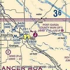
| Sectional chart |
|---|
|
| Airport distance calculator |
|---|
|
|
| Sunrise and sunset |
|---|
|
Times for 23-Dec-2025
| | Local
(UTC-6) | | Zulu
(UTC) |
|---|
| Morning civil twilight | | 07:19 | | 13:19 |
| Sunrise | | 07:47 | | 13:47 |
| Sunset | | 17:42 | | 23:42 |
| Evening civil twilight | | 18:10 | | 00:10 |
|
| Current date and time |
|---|
| Zulu (UTC) | 24-Dec-2025 00:52:48 |
|---|
| Local (UTC-6) | 23-Dec-2025 18:52:48 |
|---|
|
| METAR |
|---|
KSNK
36nm SE | 240035Z AUTO 17008KT 10SM CLR 21/10 A3016 RMK AO2 T02110095
|
KLBB
37nm NW | 232353Z 18011KT 10SM FEW250 23/M02 A3015 RMK AO2 SLP179 T02281022 10289 20217 53003
|
KLUV
40nm SW | 240035Z AUTO 16007KT 10SM SCT060 17/05 A3018 RMK AO2
|
|
| TAF |
|---|
KLBB
37nm NW | 231720Z 2318/2418 22011KT P6SM SKC FM241100 23006KT 6SM BR BKN007 FM241600 23008KT P6SM FEW250
|
|
| NOTAMs |
|---|
NOTAMs are issued by the DoD/FAA and will open in a separate window not controlled by AirNav.
|
|


