FAA INFORMATION EFFECTIVE 11 JUNE 2026
Location
| FAA Identifier: | 6J0 |
| Lat/Long: | 33-47-40.7000N 081-14-45.1000W
33-47.678333N 081-14.751667W
33.7946389,-81.2458611
(estimated) |
| Elevation: | 451.7 ft. / 137.7 m (surveyed) |
| Variation: | 07W (2010) |
| From city: | 2 miles N of PELION, SC |
| Time zone: | UTC -4 (UTC -5 during Standard Time) |
| Zip code: | 29123 |
Airport Operations
| Airport use: | Open to the public |
| Activation date: | 01/1974 |
| Control tower: | no |
| ARTCC: | JACKSONVILLE CENTER |
| FSS: | ANDERSON FLIGHT SERVICE STATION |
| NOTAMs facility: | AND (NOTAM-D service available) |
| Attendance: | UNATNDD |
| Wind indicator: | lighted |
| Segmented circle: | yes |
| Lights: | ACTVT PAPI RWY 36; MIRL RWY 18/36 - CTAF. |
| Beacon: | white-green (lighted land airport)
Operates sunset to sunrise. |
Airport Communications
| CTAF/UNICOM: | 123.0 |
| COLUMBIA APPROACH: | 124.15 |
| COLUMBIA DEPARTURE: | 124.15 |
| WX ASOS at CAE (11 nm NE): | PHONE 803-369-6879 |
| WX ASOS at CUB (16 nm NE): | 118.675 (803-929-0665) |
Nearby radio navigation aids
| VOR radial/distance | | VOR name | | Freq | | Var |
|---|
| CAEr251/10.3 | | COLUMBIA VORTAC | | 114.70 | | 02W |
| MMTr259/23.4 | | MC ENTIRE VORTAC | | 113.20 | | 08W |
| NDB name | | Hdg/Dist | | Freq | | Var | | ID |
|---|
| AIKEN | | 074/23.2 | | 347 | | 06W | | AIK | .- .. -.- |
Airport Services
| Fuel available: | 100LL |
| Parking: | tiedowns |
| Airframe service: | NONE |
| Powerplant service: | NONE |
| Bottled oxygen: | NONE |
| Bulk oxygen: | NONE |
Runway Information
Runway 18/36
| Dimensions: | 4335 x 75 ft. / 1321 x 23 m |
| Surface: | concrete, in excellent condition |
| Weight bearing capacity: | |
| Runway edge lights: | medium intensity |
| RUNWAY 18 | | RUNWAY 36 |
| Latitude: | 33-48.030508N | | 33-47.325205N |
| Longitude: | 081-14.821038W | | 081-14.682460W |
| Elevation: | 450.5 ft. | | 451.1 ft. |
| Traffic pattern: | left | | left |
| Runway heading: | 178 magnetic, 171 true | | 358 magnetic, 351 true |
| Markings: | nonprecision, in good condition | | nonprecision, in good condition |
| Visual slope indicator: | | | 2-light PAPI on left (3.00 degrees glide path) |
| Touchdown point: | yes, no lights | | yes, no lights |
| Obstructions: | 60 ft. tree, 1053 ft. from runway, 329 ft. right of centerline, 14:1 slope to clear | | 14 ft. pole, 603 ft. from runway, 227 ft. left of centerline, 28:1 slope to clear |
Airport Ownership and Management from official FAA records
| Ownership: | Publicly-owned |
| Owner: | LEXINGTON COUNTY
212 SOUTH LAKE DRIVE
LEXINGTON, SC 29072
Phone 803-785-8100 |
| Manager: | TIM SHUMPERT
440 BALL PARK ROAD
LEXINGTON, SC 29072
Phone 803-600-9313 |
Additional Remarks
| - | PLINE 800 FT FROM THLD RWY END 36; MKD WITH RED BALLS. |
| - | ACES INTO TRML BLDG, USE THE KEY PAD AND ENTER THE UNICOM FREQ. |
| - | FOR CD CTC COLUMBIA APCH AT 803-822-5242 OR 803-822-5040. |
Instrument Procedures
NOTE: All procedures below are presented as PDF files. If you need a reader for these files, you should download the free Adobe Reader.NOT FOR NAVIGATION. Please procure official charts for flight.
FAA instrument procedures published for use from 11 June 2026 at 0901Z to 09 July 2026 at 0900z.
IAPs - Instrument Approach Procedures |
|---|
| RNAV (GPS) RWY 18 | |
download (206KB) |
| RNAV (GPS) RWY 36 | |
download (209KB) |
| VOR-A | |
download (195KB) |
| NOTE: Special Take-Off Minimums/Departure Procedures apply | |
download (141KB) |
Other nearby airports with instrument procedures:
KCAE - Columbia Metro Airport (11 nm NE)
KXNO - North Air Force Auxiliary Field (14 nm SE)
KCUB - Jim Hamilton L B Owens Airport (16 nm NE)
KMMT - Mc Entire Joint National Guard Base (23 nm E)
KAIK - Aiken Regional Airport (24 nm W)
|
|

Road maps at:
MapQuest
Bing
Google
| Aerial photo |
|---|
WARNING: Photo may not be current or correct
 Photo by Jacky Shoulders
Photo taken 02-Oct-2011
looking east.
Photo by Jacky Shoulders
Photo taken 02-Oct-2011
looking east.
Do you have a better or more recent aerial photo of Lexington County Airport that you would like to share? If so, please send us your photo.
|
| Sectional chart |
|---|
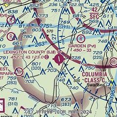
|
| Airport distance calculator |
|---|
|
|
| Sunrise and sunset |
|---|
|
Times for 07-Jul-2026
| | Local
(UTC-4) | | Zulu
(UTC) |
|---|
| Morning civil twilight | | 05:53 | | 09:53 |
| Sunrise | | 06:22 | | 10:22 |
| Sunset | | 20:38 | | 00:38 |
| Evening civil twilight | | 21:07 | | 01:07 |
|
| Current date and time |
|---|
| Zulu (UTC) | 07-Jul-2026 08:23:52 |
|---|
| Local (UTC-4) | 07-Jul-2026 04:23:52 |
|---|
|
| METAR |
|---|
KCAE
11nm NE | 070756Z 00000KT 9SM FEW002 OVC180 23/22 A2997 RMK AO2 SLP145 T02330222 $
|
KXNO
14nm SE | 070755Z AUTO 00000KT 10SM CLR 24/23 A2996 RMK AO2 SLP145 T02380227 $
|
KCUB
16nm NE | 070753Z AUTO 00000KT 10SM CLR 23/23 A2998 RMK AO2 SLP151 T02330228
|
|
| TAF |
|---|
KCAE
11nm NE | 070520Z 0706/0806 VRB04KT P6SM SCT080 BKN250 TEMPO 0708/0712 5SM BR FEW008 FM071400 25006KT P6SM FEW050 SCT150 FM071600 24010KT P6SM SCT035 BKN060 PROB30 0717/0723 VRB15G25KT 3SM -TSRA BR SCT015 BKN035CB FM080100 21005KT P6SM SCT070 BKN200
|
KCUB
16nm NE | 070520Z 0706/0806 VRB03KT P6SM SCT080 BKN250 TEMPO 0708/0712 5SM BR FEW009 FM071400 VRB04KT P6SM FEW050 SCT150 FM071600 23008KT P6SM SCT035 BKN060 PROB30 0717/0723 VRB15G25KT 3SM -TSRA BR SCT015 BKN035CB FM080100 21004KT P6SM SCT070 BKN200
|
|
| NOTAMs |
|---|
NOTAMs are issued by the DoD/FAA and will open in a separate window not controlled by AirNav.
|
|

