FAA INFORMATION EFFECTIVE 27 NOVEMBER 2025
Location
| FAA Identifier: | 9A0 |
| Lat/Long: | 34-34-59.1300N 084-01-11.8500W
34-34.985500N 084-01.197500W
34.5830917,-84.0199583
(estimated) |
| Elevation: | 1329 ft. / 405 m (estimated) |
| Variation: | 03W (1985) |
| From city: | 3 miles NW of DAHLONEGA, GA |
| Time zone: | UTC -5 (UTC -4 during Daylight Saving Time) |
| Zip code: | 30533 |
Airport Operations
| Airport use: | Open to the public |
| Activation date: | 08/1956 |
| Control tower: | no |
| ARTCC: | ATLANTA CENTER |
| FSS: | MACON FLIGHT SERVICE STATION |
| NOTAMs facility: | MCN (NOTAM-D service available) |
| Attendance: | UNATNDD |
| Wind indicator: | yes |
| Segmented circle: | no |
Airport Communications
| CTAF: | 122.9 |
| WX AWOS-3PT at DZJ (16 nm N): | 119.325 (706-745-9271) |
Nearby radio navigation aids
| VOR radial/distance | | VOR name | | Freq | | Var |
|---|
| ODFr259/36.3 | | FOOTHILLS VOR/DME | | 113.40 | | 00E |
Airport Services
| Fuel available: | 100LL
100LL:24 HR SELF SERVE WITH CREDIT CARD. |
| Parking: | tiedowns |
| Airframe service: | NONE |
| Powerplant service: | NONE |
| Bottled oxygen: | NONE |
| Bulk oxygen: | NONE |
Runway Information
Runway 16/34
| Dimensions: | 3024 x 50 ft. / 922 x 15 m |
| Surface: | asphalt, in good condition |
| Weight bearing capacity: | |
| RUNWAY 16 | | RUNWAY 34 |
| Latitude: | 34-35.201667N | | 34-34.769333N |
| Longitude: | 084-01.347667W | | 084-01.047333W |
| Elevation: | 1329.0 ft. | | 1308.2 ft. |
| Traffic pattern: | left | | left |
| Runway heading: | 153 magnetic, 150 true | | 333 magnetic, 330 true |
| Displaced threshold: | 1032 ft. | | 443 ft. |
| Markings: | basic, in fair condition | | basic, in fair condition |
| Obstructions: | 163 ft. trees, 1280 ft. from runway, 231 ft. left of centerline, 6:1 slope to clear
15:1 APCH SLP TO DSPLCD THR, TREES 2469 FT OUT & 120 FT LEFT. | | 158 ft. trees, 1535 ft. from runway, 236 ft. left of centerline, 8:1 slope to clear
APCH SLP 25:1 TO DSPLCD THR, TREELINE 2325 FT FROM DSPLCD THR. |
Airport Ownership and Management from official FAA records
| Ownership: | Publicly-owned |
| Owner: | LUMPKIN COUNTY AIRPORT AUTHORITY
99 COURTHOUSE HILL, SUITE H
DAHLONEGA, GA 30533
Phone (706) 265-0284 |
| Manager: | ASHLEY PECK
99 COURTHOUSE HILL, SUITE H
DAHLONEGA, GA 30533
Phone 706-482-2550
ARPT ADDRESS: 1682 CAMP WAHSEGA RD. |
Additional Remarks
| - | ARPT CLSD TO ACFT AT NGT, DAYTIME USE ONLY. |
| - | DEER & WILDLIFE ON OR INVOF ARPT. |
| - | FOR CD CTC ATLANTA ARTCC AT 770-210-7692. |
Instrument Procedures
There are no published instrument procedures at 9A0.
Some nearby airports with instrument procedures:
KDZJ - Blairsville Airport (16 nm N)
KGVL - Lee Gilmer Memorial Airport (21 nm SE)
KJZP - Pickens County Airport (23 nm W)
KAJR - Habersham County Airport (23 nm E)
49A - Gilmer County Airport (25 nm W)
|
|

Road maps at:
MapQuest
Bing
Google
| Aerial photo |
|---|
WARNING: Photo may not be current or correct
 Photo by Jerry Morris
Photo taken 17-Sep-2015
looking south.
Photo by Jerry Morris
Photo taken 17-Sep-2015
looking south.
Do you have a better or more recent aerial photo of Lumpkin County-Wimpys Airport that you would like to share? If so, please send us your photo.
|
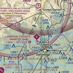
| Sectional chart |
|---|
|
| Airport distance calculator |
|---|
|
|
| Sunrise and sunset |
|---|
|
Times for 23-Dec-2025
| | Local
(UTC-5) | | Zulu
(UTC) |
|---|
| Morning civil twilight | | 07:13 | | 12:13 |
| Sunrise | | 07:41 | | 12:41 |
| Sunset | | 17:29 | | 22:29 |
| Evening civil twilight | | 17:57 | | 22:57 |
|
| Current date and time |
|---|
| Zulu (UTC) | 23-Dec-2025 06:13:27 |
|---|
| Local (UTC-5) | 23-Dec-2025 01:13:27 |
|---|
|
| METAR |
|---|
KDZJ
16nm N | 230555Z AUTO 12006KT 10SM OVC034 10/M08 A3039 RMK AO2 T00951082 10098 20089
|
KGVL
21nm SE | 230553Z AUTO 08006KT 10SM OVC043 10/M09 A3043 RMK AO2 SLP302 T01001089 10111 20094 56008
|
KAJR
23nm E | 230555Z AUTO 00000KT 10SM OVC042 09/M08 A3041 RMK AO2 T00911076 10102 20090 401230036
|
K49A
25nm W | 230555Z AUTO 00000KT 10SM OVC038 10/M02 A3039 RMK AO2
|
KCNI
26nm SW | 230555Z AUTO 10006KT 10SM OVC041 10/M08 A3041 RMK AO2 T01001077 10119 20100
|
|
| TAF |
|---|
KPDK
44nm S | 230520Z 2306/2406 11004KT P6SM SCT025 BKN040 FM231600 20004KT P6SM SCT035 BKN050 FM232000 24006KT P6SM SCT050 FM240200 VRB03KT P6SM FEW250
|
KRYY
45nm SW | 230520Z 2306/2406 12005KT P6SM SCT025 BKN040 FM231600 21004KT P6SM SCT035 BKN050 FM232000 25006KT P6SM SCT050 FM240200 VRB03KT P6SM FEW250
|
KMGE
47nm SW | 222200Z 2222/2404 13006KT 9999 BKN035 QNH3036INS BECMG 2309/2310 11004KT 9999 FEW010 BKN025 QNH3035INS BECMG 2315/2316 23009KT 9999 SCT025 BKN050 QNH3029INS BECMG 2321/2322 26012KT 9999 FEW015 BKN030 QNH3028INS TX21/2320Z TN08/2312Z LAST NO AMDS AFT 2304 NEXT 2312
|
|
| NOTAMs |
|---|
NOTAMs are issued by the DoD/FAA and will open in a separate window not controlled by AirNav.
|
|


