FAA INFORMATION EFFECTIVE 20 FEBRUARY 2025
Location
| FAA Identifier: | AHN |
| Lat/Long: | 33-56-55.1050N 083-19-33.2910W
33-56.918417N 083-19.554850W
33.9486403,-83.3259142
(estimated) |
| Elevation: | 812.2 ft. / 247.6 m (surveyed) |
| Variation: | 06W (2020) |
| From city: | 3 miles E of ATHENS, GA |
| Time zone: | UTC -5 (UTC -4 during Daylight Saving Time) |
| Zip code: | 30605 |
Airport Operations
| Airport use: | Open to the public |
| Activation date: | 07/1940 |
| Control tower: | yes |
| ARTCC: | ATLANTA CENTER |
| FSS: | MACON FLIGHT SERVICE STATION |
| NOTAMs facility: | AHN (NOTAM-D service available) |
| Attendance: | 0600-2100 |
| Pattern altitude: | 1804.2 ft. MSL |
| Wind indicator: | yes |
| Segmented circle: | yes |
| Lights: | ACTVT MALSF RWY 27; PAPI RWY 09 & 20 - CTAF. WHEN ATCT CLSD HIRL RWY 09/27 PRESET LOW INTST; TO INCR INTST ACTVT - CTAF. RWY 2 & 20 LGTS NOT AVBL WHEN ATCT IS CLSD. |
| Beacon: | white-green (lighted land airport)
Operates sunset to sunrise. |
| Fire and rescue: | ARFF index A |
| Airline operations: | INDEX B ARFF EQPT IS AVBL. |
Airport Communications
| CTAF: | 126.3 |
| UNICOM: | 122.95 |
| WX ASOS: | 132.875 (706-613-7373) |
| ATHENS GROUND: | 121.8 [0800-2000] |
| ATHENS TOWER: | 126.3 338.275 [0800-2000] |
| ATLANTA APPROACH: | 132.475 ;0615-2200 |
| ATLANTA DEPARTURE: | 132.475 ;0615-2200 |
| CLEARANCE DELIVERY: | 121.8 |
| WX AWOS-3 at WDR (17 nm W): | 118.575 (770-868-0642) |
| WX AWOS-3PT at JCA (18 nm NW): | 118.125 (706-387-6477) |
- APCH/DEP SVC AND CLNC DEL PRVDD BY ATLANTA TRACON (A80) ON FREQS 132.475/291.1 0615-2200; APCH/DEP SVC PRVDD BY ATLANTA ARTCC (ZTL) ON FREQS 134.8/379.95, 2200-0615 (FOOTHILLS RCAG).
Nearby radio navigation aids
| VOR radial/distance | | VOR name | | Freq | | Var |
|---|
| AHN at field | | ATHENS VOR/DME | | 116.95 | | 00E |
| ELWr224/39.0 | | ELECTRIC CITY VORTAC | | 108.60 | | 00E |
| NDB name | | Hdg/Dist | | Freq | | Var | | ID |
|---|
| BARROW COUNTY | | 092/13.1 | | 404 | | 05W | | BMW | -... -- .-- |
Airport Services
| Fuel available: | 100LL JET-A JET-A1 |
| Parking: | hangars and tiedowns |
| Airframe service: | MAJOR |
| Powerplant service: | MAJOR |
| Bottled oxygen: | NONE |
| Bulk oxygen: | NONE |
Runway Information
Runway 9/27
| Dimensions: | 6122 x 100 ft. / 1866 x 30 m |
| Surface: | asphalt/grooved, in excellent condition |
| Weight bearing capacity: | | PCN 47 /F/B/X/T | | Single wheel: | 65.0 | | Double wheel: | 125.0 |
|
| Runway edge lights: | high intensity |
| RUNWAY 9 | | RUNWAY 27 |
| Latitude: | 33-56.934637N | | 33-56.964227N |
| Longitude: | 083-20.292562W | | 083-19.082013W |
| Elevation: | 755.5 ft. | | 811.9 ft. |
| Traffic pattern: | left | | left |
| Runway heading: | 094 magnetic, 088 true | | 274 magnetic, 268 true |
| Markings: | nonprecision, in good condition | | precision, in good condition |
| Visual slope indicator: | 4-light PAPI on left (3.00 degrees glide path) | | 4-light PAPI on left (3.00 degrees glide path) |
| Approach lights: | | | MALSF: 1,400 foot medium intensity approach lighting system with sequenced flashers |
| Runway end identifier lights: | | | no |
| Touchdown point: | yes, no lights | | yes, no lights |
| Instrument approach: | | | LOC/GS |
Runway 2/20
| Dimensions: | 3995 x 100 ft. / 1218 x 30 m |
| Surface: | asphalt, in excellent condition |
| Weight bearing capacity: | | PCN 7 /F/B/X/T | | Single wheel: | 40.0 | | Double wheel: | 45.0 |
|
| Runway edge lights: | medium intensity |
| Operational restrictions: | RWY 2/20 NOT AVBL FOR SKED ACR OPNS WITH MORE THAN 9 PSGR SEATS OR UNSKED ACR AT LEAST 31 PSGR SEATS. |
| RUNWAY 2 | | RUNWAY 20 |
| Latitude: | 33-56.562945N | | 33-57.178717N |
| Longitude: | 083-19.492172W | | 083-19.211640W |
| Elevation: | 774.6 ft. | | 803.3 ft. |
| Traffic pattern: | left | | left |
| Runway heading: | 027 magnetic, 021 true | | 207 magnetic, 201 true |
| Markings: | nonprecision, in good condition | | nonprecision, in good condition |
| Visual slope indicator: | 4-box VASI on left (3.75 degrees glide path) | | 4-light PAPI on left (3.00 degrees glide path) |
| Touchdown point: | yes, no lights | | yes, no lights |
| Obstructions: | 72 ft. trees, 1500 ft. from runway, 150 ft. left of centerline, 20:1 slope to clear | | 63 ft. trees, 1475 ft. from runway, 250 ft. right of centerline, 20:1 slope to clear |
Airport Ownership and Management from official FAA records
| Ownership: | Publicly-owned |
| Owner: | CLARKE COUNTY
PO BOX 448, CO COURTHOUSE
ATHENS, GA 30601
Phone 706-613-3420 |
| Manager: | MIKE MATTHEWS
1010 BEN EPPS DRIVE
ATHENS, GA 30605
Phone 706-613-3416 |
Additional Remarks
| - | NOISE SENSITIVE AREA S OF ARPT; CTC FBO FOR INFORMATION. |
| - | CLSD TO UNSKED ACR OPNS WITH MORE THAN 30 PSGR SEATS EXCP 24 HRS PPR CALL AMGR 706-613-3420. |
| - | FOR CD IF UNA TO CTC ON FSS FREQ, CTC ATLANTA APCH AT 678-364-6131, WHEN ATCT CLSD CTC ATLANTA ARTCC AT 770-210-7692. |
Instrument Procedures
NOTE: All procedures below are presented as PDF files. If you need a reader for these files, you should download the free Adobe Reader.NOT FOR NAVIGATION. Please procure official charts for flight.
FAA instrument procedures published for use from 20 February 2025 at 0901Z to 20 March 2025 at 0900Z.
IAPs - Instrument Approach Procedures |
|---|
| ILS OR LOC/DME RWY 27 | |
download (330KB) |
| RNAV (GPS) RWY 02 | |
download (246KB) |
| RNAV (GPS) RWY 09 | |
download (242KB) |
| RNAV (GPS) RWY 20 | |
download (239KB) |
| RNAV (GPS) RWY 27 | |
download (294KB) |
| VOR RWY 02 | |
download (204KB) |
| NOTE: Special Alternate Minimums apply | |
download (158KB) |
| NOTE: Special Take-Off Minimums/Departure Procedures apply | |
download (286KB) |
Other nearby airports with instrument procedures:
KWDR - Barrow County Airport (17 nm W)
KJCA - Jackson County Airport (18 nm NW)
D73 - Cy Nunnally Memorial Airport (21 nm SW)
52A - Madison Municipal Airport (21 nm S)
KCPP - Greene County Regional Airport (23 nm SE)
|
|

Road maps at:
MapQuest
Bing
Google
| Aerial photo |
|---|
WARNING: Photo may not be current or correct
 Photo courtesy of AirNav, LLC
Photo taken 26-Nov-2017
looking northeast.
Photo courtesy of AirNav, LLC
Photo taken 26-Nov-2017
looking northeast.
Do you have a better or more recent aerial photo of Athens/Ben Epps Airport that you would like to share? If so, please send us your photo.
|
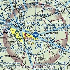
| Sectional chart |
|---|
|
CAUTION: Diagram may not be current
 Download PDF
of official airport diagram from the FAA
| Airport distance calculator |
|---|
|
|
| Sunrise and sunset |
|---|
|
Times for 10-Mar-2025
| | Local
(UTC-5) | | Zulu
(UTC) |
|---|
| Morning civil twilight | | 06:27 | | 11:27 |
| Sunrise | | 06:51 | | 11:51 |
| Sunset | | 18:36 | | 23:36 |
| Evening civil twilight | | 19:01 | | 00:01 |
|
| Current date and time |
|---|
| Zulu (UTC) | 11-Mar-2025 03:24:38 |
|---|
| Local (UTC-5) | 10-Mar-2025 22:24:38 |
|---|
|
| METAR |
|---|
| KAHN | 110301Z AUTO 00000KT 3/4SM BR CLR 04/04 A2986 RMK AO2 T00440039 $
|
KWDR
17nm W | 110255Z AUTO 00000KT 3SM BR CLR 04/04 A2988 RMK AO2
|
KJCA
18nm NW | 110255Z AUTO 28007KT 10SM CLR 05/ A2987 RMK AO2 T0047////
|
|
| TAF |
|---|
| KAHN | 101739Z 1018/1118 03009KT 6SM -RA SCT007 SCT015 BKN050 TEMPO 1019/1021 BKN015 FM102200 01007KT 6SM -RA SCT015 BKN025 FM110000 33004KT P6SM FEW040 FM111500 31008KT P6SM SKC
|
|
| NOTAMs |
|---|
NOTAMs are issued by the DoD/FAA and will open in a separate window not controlled by AirNav.
|
|


