FAA INFORMATION EFFECTIVE 19 FEBRUARY 2026
Location
| FAA Identifier: | C47 |
| Lat/Long: | 43-33-36.9440N 089-28-58.4810W
43-33.615733N 089-28.974683W
43.5602622,-89.4829114
(estimated) |
| Elevation: | 824.8 ft. / 251.4 m (surveyed) |
| Variation: | 03W (2020) |
| From city: | 2 miles NW of PORTAGE, WI |
| Time zone: | UTC -6 (UTC -5 during Daylight Saving Time) |
| Zip code: | 53901 |
Airport Operations
| Airport use: | Open to the public |
| Activation date: | 10/1941 |
| Control tower: | no |
| ARTCC: | CHICAGO CENTER |
| FSS: | GREEN BAY FLIGHT SERVICE STATION |
| NOTAMs facility: | GRB (NOTAM-D service available) |
| Attendance: | MON-FRI 0900-1500 |
| Wind indicator: | yes |
| Segmented circle: | yes |
| Beacon: | white-green (lighted land airport)
Operates sunset to sunrise. |
Airport Communications
| CTAF/UNICOM: | 122.7 |
| MADISON APPROACH: | 135.45 |
| CHICAGO ARTCC APPROACH: | 120.1 |
| MADISON DEPARTURE: | 135.45 |
| CHICAGO ARTCC DEPARTURE: | 120.1 |
| WX AWOS-3 at DLL (13 nm W): | 118.325 (608-356-1071) |
- APCH/DEP SVC PRVDD BY CHICAGO ARTCC ON FREQS 133.3/257.925 (LONE ROCK RCAG) WHEN MADISON APCH CTL CLSD.
Nearby radio navigation aids
| VOR radial/distance | | VOR name | | Freq | | Var |
|---|
| DLLr084/12.2 | | DELLS VORTAC | | 117.00 | | 03E |
| MSNr343/25.7 | | MADISON VORTAC | | 108.60 | | 03E |
Airport Services
| Fuel available: | 100LL UL91
100LL:FUEL AVBL 24 HRS WITH CREDIT CARD. |
| Parking: | hangars and tiedowns |
| Airframe service: | NONE |
| Powerplant service: | NONE |
| Bottled oxygen: | NONE |
| Bulk oxygen: | NONE |
Runway Information
Runway 18/36
| Dimensions: | 3770 x 60 ft. / 1149 x 18 m |
| Surface: | asphalt, in good condition |
| Runway edge lights: | non-standard
MIRL NSTD. RWY 18 FIRST 100 FT NOT LGTD; RWY 36 FIRST 193 FT NOT LGTD. |
| RUNWAY 18 | | RUNWAY 36 |
| Latitude: | 43-33.947047N | | 43-33.326908N |
| Longitude: | 089-29.000997W | | 089-28.968648W |
| Elevation: | 811.3 ft. | | 821.9 ft. |
| Traffic pattern: | left | | left |
| Runway heading: | 181 magnetic, 178 true | | 001 magnetic, 358 true |
| Displaced threshold: | 98 ft. | | 262 ft. |
| Markings: | nonprecision, in good condition | | nonprecision, in good condition |
| Visual slope indicator: | 2-light PAPI on left (3.75 degrees glide path) | | |
| Runway end identifier lights: | yes | | no |
| Touchdown point: | yes, no lights | | yes, no lights |
| Obstructions: | 2 ft. road, 200 ft. from runway, 20 ft. left of centerline
2 FT RD AT RWY END; 170 FT RIGHT. | | 63 ft. trees, 325 ft. from runway, 220 ft. left of centerline, 1:1 slope to clear
14 FT RD 42 FT FM RWY END; 28 FT POLE 30 FT FM RWY END, 125 FT L. |
Runway 4/22
| Dimensions: | 2668 x 40 ft. / 813 x 12 m |
| Surface: | asphalt/aggregate friction seal coat, in fair condition |
| Operational restrictions: | RWY NOT PLOWED DURG WINTER, CFM COND WITH AMGR. |
| RUNWAY 4 | | RUNWAY 22 |
| Latitude: | 43-33.425270N | | 43-33.746185N |
| Longitude: | 089-29.166462W | | 089-28.754233W |
| Elevation: | 824.7 ft. | | 815.8 ft. |
| Traffic pattern: | left | | left |
| Runway heading: | 046 magnetic, 043 true | | 226 magnetic, 223 true |
| Displaced threshold: | 109 ft. | | no |
| Markings: | basic, in good condition | | basic, in good condition |
| Runway end identifier lights: | no | | no |
| Touchdown point: | yes, no lights | | yes, no lights |
| Obstructions: | 15 ft. road, 200 ft. from runway, 80 ft. right of centerline
30 FT TREES 40 FT FM RWY END; 100 FT L. | | 58 ft. trees, 814 ft. from runway, 164 ft. left of centerline, 10:1 slope to clear
6 FT TRRN AT THR; 90 FT L. |
Airport Ownership and Management from official FAA records
| Ownership: | Publicly-owned |
| Owner: | CITY OF PORTAGE
115 PLEASANT
PORTAGE, WI 53901
Phone 608-742-2176 |
| Manager: | PHIL LIVINGSTON
115 W PLEASANT ST, BOX 319
PORTAGE, WI 53901
Phone 608-742-2176
EXT 104. |
Additional Remarks
| - | DEER ON & INVOF OF ARPT. |
| - | RWY 36 LRG HNGRS & TREE 200 FT W OF MAY CAUSE WIND SHEAR WITH STRONG NW WINDS. |
| - | POWERLINE 110 FT AGL 1580 FT FM DSPLCD THLD RY 36. |
| - | FOR CD CTC MADISON APP/DEP CON AT 608-249-8240. WHEN MADISON APCH CLSD, FOR CD CTC CHICAGO ARTCC AT 630-906-8921. |
Instrument Procedures
NOTE: All procedures below are presented as PDF files. If you need a reader for these files, you should download the free Adobe Reader.NOT FOR NAVIGATION. Please procure official charts for flight.
FAA instrument procedures published for use from 19 February 2026 at 0901Z to 19 March 2026 at 0900Z.
IAPs - Instrument Approach Procedures |
|---|
| RNAV (GPS) RWY 18 **CHANGED** | |
download (203KB) |
| NOTE: Special Take-Off Minimums/Departure Procedures apply | |
download (334KB) |
Other nearby airports with instrument procedures:
KDLL - Baraboo/Wisconsin Dells Regional Airport (13 nm W)
91C - Sauk/Prairie Airport (20 nm SW)
C35 - Reedsburg Municipal Airport (22 nm W)
KMSN - Dane County Regional Airport-Truax Field (26 nm S)
C29 - Middleton Municipal Airport - Morey Field (27 nm S)
|
|

Road maps at:
MapQuest
Bing
Google
| Aerial photo |
|---|
WARNING: Photo may not be current or correct
 Photo by Bob Johnson
Photo taken 01-Jul-2020
looking north.
Photo by Bob Johnson
Photo taken 01-Jul-2020
looking north.
Do you have a better or more recent aerial photo of Portage Municipal Airport that you would like to share? If so, please send us your photo.
|
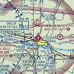
| Sectional chart |
|---|
|
| Airport distance calculator |
|---|
|
|
| Sunrise and sunset |
|---|
|
Times for 14-Mar-2026
| | Local
(UTC-5) | | Zulu
(UTC) |
|---|
| Morning civil twilight | | 06:44 | | 11:44 |
| Sunrise | | 07:13 | | 12:13 |
| Sunset | | 19:02 | | 00:02 |
| Evening civil twilight | | 19:30 | | 00:30 |
|
| Current date and time |
|---|
| Zulu (UTC) | 14-Mar-2026 09:53:30 |
|---|
| Local (UTC-5) | 14-Mar-2026 04:53:30 |
|---|
|
| METAR |
|---|
KDLL
13nm W | 140935Z AUTO 00000KT 10SM CLR M07/M10 A3011 RMK AO2 T10701098
|
KC35
22nm W | 140935Z AUTO 00000KT 10SM M04/M08 A3011 RMK AO2 T10451085 PWINO
|
|
| TAF |
|---|
KMSN
26nm S | 140520Z 1406/1506 32005KT P6SM FEW250 FM140900 00000KT P6SM BKN120 FM141700 15005KT P6SM OVC090 FM142300 12010KT P6SM OVC060 FM150300 11012G24KT P6SM OVC060 PROB30 1503/1506 4SM -SN OVC025
|
|
| NOTAMs |
|---|
NOTAMs are issued by the DoD/FAA and will open in a separate window not controlled by AirNav.
|
|

