FAA INFORMATION EFFECTIVE 11 JUNE 2026
Location
| FAA Identifier: | CQW |
| Lat/Long: | 34-42-46.3000N 079-57-25.2000W
34-42.771667N 079-57.420000W
34.7128611,-79.9570000
(estimated) |
| Elevation: | 238.7 ft. / 72.8 m (surveyed) |
| Variation: | 08W (2005) |
| From city: | 3 miles NW of CHERAW, SC |
| Time zone: | UTC -4 (UTC -5 during Standard Time) |
| Zip code: | 29520 |
Airport Operations
| Airport use: | Open to the public |
| Activation date: | 02/1945 |
| Control tower: | no |
| ARTCC: | JACKSONVILLE CENTER |
| FSS: | ANDERSON FLIGHT SERVICE STATION |
| NOTAMs facility: | AND (NOTAM-D service available) |
| Attendance: | MON-SAT 0800-1800, ALL SUN 1300-1700 |
| Wind indicator: | lighted |
| Segmented circle: | yes |
| Lights: | ACTVT REILS RWY 08 & 26; MIRL RWY 08/26; AND WND CONE LGT - CTAF. |
| Beacon: | white-green (lighted land airport)
Operates sunset to sunrise. |
Airport Communications
| CTAF/UNICOM: | 122.8 |
| WX AWOS-3: | 124.825 (843-537-3301) |
| FLORENCE APPROACH: | 118.6 |
| FLORENCE DEPARTURE: | 118.6 |
| WX AWOS-3PT at BBP (12 nm SE): | 123.825 (843-479-5817) |
| WX AWOS-3 at RCZ (14 nm NE): | 118.775 (910-997-4093) |
| WX AWOS-3PT at UDG (16 nm S): | 119.925 (843-393-8220) |
| WX AWOS-3 at AFP (19 nm N): | 119.325 (704-695-0623) |
- APCH/DEP SVC PRVDD BY JACKSONVILLE ARTCC ON FREQS 133.45/306.3 (FLORENCE RCAG) WHEN FLORENCE APCH CTL CLSD.
Nearby radio navigation aids
| VOR radial/distance | | VOR name | | Freq | | Var |
|---|
| CTFr080/16.1 | | CHESTERFIELD VOR/DME | | 114.55 | | 03W |
| FLOr336/32.4 | | FLORENCE VORTAC | | 115.20 | | 03W |
| SDZr214/35.2 | | SANDHILLS VORTAC | | 111.80 | | 03W |
| NDB name | | Hdg/Dist | | Freq | | Var | | ID |
|---|
| HARTSVILLE | | 031/20.1 | | 341 | | 07W | | HVS | .... ...- ... |
Airport Services
| Fuel available: | 100LL JET-A |
| Parking: | tiedowns |
| Airframe service: | MAJOR |
| Powerplant service: | MAJOR |
| Bottled oxygen: | NONE |
| Bulk oxygen: | NONE |
Runway Information
Runway 8/26
| Dimensions: | 5000 x 75 ft. / 1524 x 23 m |
| Surface: | asphalt/porous friction courses, in fair condition |
| Weight bearing capacity: | | Single wheel: | 30.0 | | Double wheel: | 48.0 |
|
| Runway edge lights: | medium intensity |
| RUNWAY 8 | | RUNWAY 26 |
| Latitude: | 34-42.632012N | | 34-42.912787N |
| Longitude: | 079-57.889422W | | 079-56.950967W |
| Elevation: | 238.7 ft. | | 187.9 ft. |
| Traffic pattern: | left | | left |
| Runway heading: | 078 magnetic, 070 true | | 258 magnetic, 250 true |
| Markings: | nonprecision, in good condition | | nonprecision, in good condition |
| Runway end identifier lights: | yes | | yes |
| Touchdown point: | yes, no lights | | yes, no lights |
| Obstructions: | 46 ft. tree, 906 ft. from runway, 157 ft. left of centerline, 15:1 slope to clear | | 22 ft. pole, 493 ft. from runway, 187 ft. left of centerline, 13:1 slope to clear |
Airport Ownership and Management from official FAA records
| Ownership: | Publicly-owned |
| Owner: | TOWN OF CHERAW
P O BOX 111
CHERAW, SC 29520
Phone 843-537-7283 |
| Manager: | BRIAN ROGERS
PO BOX 219
CHERAW, SC 29520
Phone 843-537-8400 |
Additional Remarks
| - | FOR CD CTC FLORENCE APCH AT 843-665-0632, WHEN APCH CLSD CTC JACKSONVILLE ARTCC AT 904-845-1592. |
Instrument Procedures
NOTE: All procedures below are presented as PDF files. If you need a reader for these files, you should download the free Adobe Reader.NOT FOR NAVIGATION. Please procure official charts for flight.
FAA instrument procedures published for use from 11 June 2026 at 0901Z to 09 July 2026 at 0900z.
IAPs - Instrument Approach Procedures |
|---|
| RNAV (GPS) RWY 08 | |
download (222KB) |
| RNAV (GPS) RWY 26 | |
download (251KB) |
| VOR/DME RWY 08 | |
download (211KB) |
| NOTE: Special Alternate Minimums apply | |
download (166KB) |
| NOTE: Special Take-Off Minimums/Departure Procedures apply | |
download (364KB) |
Other nearby airports with instrument procedures:
KBBP - Marlboro County Jetport/H E Avent Field Airport (12 nm SE)
KRCZ - Richmond County Airport (14 nm NE)
KUDG - Darlington County Airport (16 nm S)
KPYG - Pageland Airport (19 nm W)
KAFP - Anson County Airport - Jeff Cloud Field (19 nm N)
|
|

Road maps at:
MapQuest
Bing
Google
| Aerial photo |
|---|
WARNING: Photo may not be current or correct
 Photo by Ed Morrison
Photo taken 08-Jul-2012
looking west.
Photo by Ed Morrison
Photo taken 08-Jul-2012
looking west.
Do you have a better or more recent aerial photo of Cheraw Municipal Airport/Lynch Bellinger Field that you would like to share? If so, please send us your photo.
|
| Sectional chart |
|---|
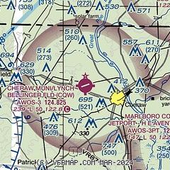
|
| Airport distance calculator |
|---|
|
|
| Sunrise and sunset |
|---|
|
Times for 24-Jun-2026
| | Local
(UTC-4) | | Zulu
(UTC) |
|---|
| Morning civil twilight | | 05:39 | | 09:39 |
| Sunrise | | 06:09 | | 10:09 |
| Sunset | | 20:36 | | 00:36 |
| Evening civil twilight | | 21:05 | | 01:05 |
|
| Current date and time |
|---|
| Zulu (UTC) | 24-Jun-2026 14:31:32 |
|---|
| Local (UTC-4) | 24-Jun-2026 10:31:32 |
|---|
|
| METAR |
|---|
| KCQW | 241415Z AUTO 04008KT 10SM CLR 26/14 A3010 RMK AO2
|
KBBP
12nm SE | 241415Z AUTO 04004KT 10SM CLR 25/16 A3010 RMK AO2
|
KRCZ
14nm NE | 241415Z AUTO 05005KT 10SM CLR 25/13 A3011 RMK AO2 T02530134
|
KUDG
16nm S | 241356Z AUTO 04008KT 10SM CLR 26/15 A3011 RMK AO2 SLP196 T02610150 $
|
KAFP
19nm N | 241415Z AUTO 05006KT 10SM CLR 26/13 A3011 RMK AO2 T02570126
|
|
| TAF |
|---|
KFLO
34nm S | 241120Z 2412/2512 03008KT P6SM BKN070 FM241800 VRB05KT P6SM SCT070 FM250100 00000KT P6SM FEW200
|
|
| NOTAMs |
|---|
NOTAMs are issued by the DoD/FAA and will open in a separate window not controlled by AirNav.
|
|

