FAA INFORMATION EFFECTIVE 07 AUGUST 2025
Location
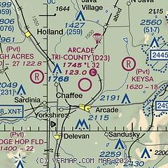
| FAA Identifier: | D23 |
| Lat/Long: | 42-34-00.2230N 078-25-34.0660W
42-34.003717N 078-25.567767W
42.5667286,-78.4261294
(estimated) |
| Elevation: | 1745 ft. / 532 m (estimated) |
| Variation: | 10W (1985) |
| From city: | 2 miles N of ARCADE, NY |
| Time zone: | UTC -4 (UTC -5 during Standard Time) |
| Zip code: | 14009 |
Airport Operations
| Airport use: | Open to the public |
| Control tower: | no |
| ARTCC: | CLEVELAND CENTER |
| FSS: | BUFFALO FLIGHT SERVICE STATION |
| NOTAMs facility: | BUF (NOTAM-D service available) |
| Attendance: | UNATNDD |
| Wind indicator: | yes |
| Segmented circle: | no |
| Lights: | ACTVT MIRL RWY 09/27 - 123.0. |
Airport Communications
| CTAF/UNICOM: | 123.0 |
| WX AWOS-2 at 01G (20 nm NE): | 118.525 (585-237-0235) |
| WX AWOS-3 at OLE (20 nm S): | 118.375 (716-557-2001) |
Nearby radio navigation aids
| VOR radial/distance | | VOR name | | Freq | | Var |
|---|
| GEEr251/34.5 | | GENESEO VOR/DME | | 108.20 | | 09W |
| JHWr061/38.3 | | JAMESTOWN VOR/DME | | 114.70 | | 07W |
Airport Services
| Parking: | hangars and tiedowns |
| Airframe service: | NONE |
| Powerplant service: | NONE |
| Bottled oxygen: | NONE |
| Bulk oxygen: | NONE |
Runway Information
Runway 9/27
| Dimensions: | 3220 x 60 ft. / 981 x 18 m |
| Surface: | gravel, in fair condition |
| Runway edge lights: | non-standard
MIRLS ALONG EDGES ONLY, NO THLD LGTS. |
| RUNWAY 9 | | RUNWAY 27 |
| Traffic pattern: | left | | left |
| Obstructions: | 43 ft. trees, 10 ft. from runway, 74 ft. right of centerline
RWY 27 56 FT POLE, 780 FT DSTC, 130 FT R, 13:1. UNMKD & UNLGTD. | | 20 ft. trees, 89 ft. from runway, 130 ft. right of centerline, 4:1 slope to clear |
Runway 14/32
| Dimensions: | 2710 x 80 ft. / 826 x 24 m |
| Surface: | turf, in good condition |
| RUNWAY 14 | | RUNWAY 32 |
| Traffic pattern: | left | | left |
| Obstructions: | 10 ft. brush, 135 ft. right of centerline, 1:1 slope to clear
NMRS TREES +15 TO +70 FT BOTH SIDES OF RWY 14. | | 45 ft. trees, 27 ft. from runway, 79 ft. right of centerline, 1:1 slope to clear
NMRS TREES +15 TO +75 FT BOTH SIDES OF RWY 32. |
Airport Ownership and Management from official FAA records
| Ownership: | Privately-owned |
| Owner: | ARMSTRONG ENTERPRISES, LLC
P.O. BOX 144
ARCADE, NY 14009
Phone 716-864-0062 |
| Manager: | TERRY ARMSTRONG
6715 NORTHWOODS RD, P. O. BOX 144
ARCADE, NY 14009
Phone 716-864-3354 |
Additional Remarks
| - | ULTRALGT ACFT PROHIBITED. |
| - | ARPT CLSD WINTER MONTHS - CALL MGR |
| - | FOR CD CTC CLEVELAND ARTCC AT 440-774-0490. |
| - | DEER ON AND INVOF ARPT. |
| - | PPR. |
Instrument Procedures
There are no published instrument procedures at D23.
Some nearby airports with instrument procedures:
KOLE - Cattaraugus County-Olean Airport (20 nm S)
9G0 - Buffalo Airfield (22 nm NW)
KBQR - Buffalo-Lancaster Regional Airport (23 nm N)
KBUF - Buffalo Niagara International Airport (26 nm NW)
9G3 - Akron Airport/Jesson Field (27 nm N)
|
|

Road maps at:
MapQuest
Bing
Google
| Aerial photo |
|---|
WARNING: Photo may not be current or correct
 Photo taken 30-Sep-2012
looking east.
Photo taken 30-Sep-2012
looking east.
Do you have a better or more recent aerial photo of Arcade Tri-County Airport that you would like to share? If so, please send us your photo.
|
| Sectional chart |
|---|
|
| Airport distance calculator |
|---|
|
|
| Sunrise and sunset |
|---|
|
Times for 24-Aug-2025
| | Local
(UTC-4) | | Zulu
(UTC) |
|---|
| Morning civil twilight | | 06:01 | | 10:01 |
| Sunrise | | 06:31 | | 10:31 |
| Sunset | | 20:01 | | 00:01 |
| Evening civil twilight | | 20:31 | | 00:31 |
|
| Current date and time |
|---|
| Zulu (UTC) | 24-Aug-2025 09:14:20 |
|---|
| Local (UTC-4) | 24-Aug-2025 05:14:20 |
|---|
|
| METAR |
|---|
KOLE
20nm S | 240855Z AUTO 00000KT 3/4SM BR OVC002 A2992 RMK AO2 LTG DSNT NE
|
KBUF
26nm NW | 240854Z 22006KT 10SM FEW030 FEW100 SCT200 19/16 A2982 RMK AO2 SLP095 60000 T01890161 55001 $
|
KDSV
31nm E | 240854Z AUTO 00000KT 10SM FEW075 FEW120 21/19 A2986 RMK AO2 SLP115 60000 T02110189 55003
|
KELZ
34nm SE | 240856Z AUTO 23005KT 10SM SCT022 BKN028 OVC034 18/17 A2993 RMK AO2 SLP122 60003 T01780167 57003
|
KDKK
38nm W | 240853Z AUTO 23005KT 10SM CLR 19/16 A2985 RMK AO2 SLP103 60000 T01940161 55000 $
|
KIAG
40nm NW | 240853Z AUTO 26006KT 8SM CLR 17/16 A2982 RMK AO2 SLP094 T01670161 53003
|
|
| TAF |
|---|
KBUF
26nm NW | 240531Z 2406/2506 20008KT P6SM SCT060 BKN090 PROB30 2406/2410 6SM -SHRA BKN030 FM241000 22007KT P6SM BKN090 FM241600 24009KT P6SM SCT080 FM250000 24007KT P6SM FEW150 FM250300 23005KT P6SM FEW090
|
|
| NOTAMs |
|---|
NOTAMs are issued by the DoD/FAA and will open in a separate window not controlled by AirNav.
|
|

