FAA INFORMATION EFFECTIVE 27 NOVEMBER 2025
Location
| FAA Identifier: | GSP |
| Lat/Long: | 34-53-44.4160N 082-13-07.8940W
34-53.740267N 082-13.131567W
34.8956711,-82.2188594
(estimated) |
| Elevation: | 963.6 ft. / 293.7 m (surveyed) |
| Variation: | 06W (2010) |
| From city: | 3 miles S of GREER, SC |
| Time zone: | UTC -5 (UTC -4 during Daylight Saving Time) |
| Zip code: | 29651 |
Airport Operations
| Airport use: | Open to the public |
| Activation date: | 11/1962 |
| Control tower: | yes |
| ARTCC: | ATLANTA CENTER |
| FSS: | ANDERSON FLIGHT SERVICE STATION |
| NOTAMs facility: | GSP (NOTAM-D service available) |
| Attendance: | CONTINUOUS |
| Wind indicator: | lighted |
| Segmented circle: | yes |
| Lights: | WHEN ATCT CLSD ACTVT MALSR RWY 22; CNTLN RWY 22; HIRL RWY 04/22 - CTAF. |
| Beacon: | white-green (lighted land airport)
Operates sunset to sunrise. |
| Fire and rescue: | ARFF index C |
| International operations: | customs landing rights airport |
Airport Communications
| CTAF: | 120.1 |
| UNICOM: | 122.95 |
| ATIS: | 134.25 |
| WX ASOS: | PHONE 864-334-6232 |
| GREER GROUND: | 121.9 [0600-2345] |
| GREER TOWER: | 120.1 251.15 [0600-2345] |
| GREER APPROACH: | 118.8 ;WEST 119.4 ;EAST 270.275 ;WEST 350.2 ;EAST [0600-2345] |
| ATLANTA ARTCC APPROACH: | 120.6 120.6 [2345-0600] |
| GREER DEPARTURE: | 118.8 ;WEST 119.4 ;EAST 270.275 ;WEST 350.2 ;EAST [0600-2345] |
| ATLANTA ARTCC DEPARTURE: | 120.6 [2345-0600] |
| CLEARANCE DELIVERY: | 121.9 |
| BIMMR DP: | 119.4 350.2 |
| BWALL DP: | 119.4 350.2 |
| CLASS C: | 118.8 ;WEST 119.4 ;EAST 270.275 ;WEST 350.2 ;EAST |
| EMERG: | 121.5 |
| IC: | 118.8 ;WEST 270.275 ;WEST |
| JUNNR STAR: | 118.8 ;WEST 119.4 ;EAST 270.275 ;WEST 350.2 ;EAST |
| MCHLN STAR: | 119.4 350.2 |
| RCTOR STAR: | 118.8 270.275 |
| WORXS STAR: | 118.8 270.275 |
| WX ASOS at GMU (7 nm SW): | 127.075 (864-239-0014) |
| WX AWOS-3 at GYH (11 nm SW): | 127.325 (864-277-5674) |
| WX AWOS-3 at SPA (13 nm E): | 133.925 (864-587-2529) |
- APCH/DEP SVC PRVDD BY ATLANTA ARTCC ON FREQS 135.35/263.125 (OWING RCAG) WHEN APCH CTL CLSD.
Nearby radio navigation aids
| VOR radial/distance | | VOR name | | Freq | | Var |
|---|
| SPAr242/16.6 | | SPARTANBURG VORTAC | | 115.70 | | 02W |
| SUGr177/30.7 | | SUGARLOAF MOUNTAIN VORTAC | | 112.20 | | 02W |
| ELWr044/40.0 | | ELECTRIC CITY VORTAC | | 108.60 | | 00E |
Airport Services
| Fuel available: | 100LL JET-A
100LL:FUEL ICING INHIBITOR AVBL. |
| Parking: | hangars and tiedowns |
| Airframe service: | MAJOR |
| Powerplant service: | MAJOR |
| Bottled oxygen: | LOW |
| Bulk oxygen: | LOW |
Runway Information
Runway 4/22
| Dimensions: | 11001 x 150 ft. / 3353 x 46 m |
| Surface: | asphalt/concrete/grooved, in good condition
RWY 04/22 SOUTH 2525 FT CONC, NORTH 1925 FT CONC, CENTER 6551 ASPH. |
| Weight bearing capacity: | | Single wheel: | 100.0 | | Double wheel: | 210.0 | | Double tandem: | 625.0 | | Dual double tandem: | 975.0 |
|
| Runway edge lights: | high intensity |
| RUNWAY 4 | | RUNWAY 22 |
| Latitude: | 34-52.973110N | | 34-54.507370N |
| Longitude: | 082-13.718117W | | 082-12.544825W |
| Elevation: | 940.8 ft. | | 963.6 ft. |
| Traffic pattern: | right | | left |
| Runway heading: | 038 magnetic, 032 true | | 218 magnetic, 212 true |
| Markings: | precision, in good condition | | precision, in good condition |
| Visual slope indicator: | 4-light PAPI on left (3.00 degrees glide path) | | 4-light PAPI on right (3.00 degrees glide path) |
| RVR equipment: | touchdown, midfield, rollout | | touchdown, midfield, rollout |
| Approach lights: | ALSF2: standard 2,400 foot high intensity approach lighting system with centerline sequenced flashers (category II or III)
RWY 04 ALSF2 STEP 3 ONLY WHEN ATCT CLSD. | | MALSR: 1,400 foot medium intensity approach lighting system with runway alignment indicator lights |
| Centerline lights: | yes | | yes |
| Touchdown point: | yes, lighted | | yes, no lights |
| Instrument approach: | ILS/DME | | ILS |
Airport Ownership and Management from official FAA records
| Ownership: | Publicly-owned |
| Owner: | GREENVILLE-SPARTANBURG ACMSN
2000 GSP DRIVE, SUITE 1
GREER, SC 29651-9202
Phone 864-877-7426 |
| Manager: | DAVID EDWARDS, JR.
2000 GSP DRIVE, SUITE 1
GREER, SC 29651-9202
Phone (864) 848-6272 |
Additional Remarks
| A39-04/22 | PCR VALUE: 1050/F/B/X/T |
| E115 | JOINT USE AGREEMENT FOR EMERGENCY USE. |
| - | PPR GA OR MIL ACFT HEAVIER THAN 120,000 LBS CTC APT OPS 864-848-6233 |
| - | HEAVY ACFT DO NOT MAKE MORE THAN 90 DEG TURN ON ASPH PORTIONS OF THE RWY OR PARL TWY LIMA; OR TWYS D, E, F, G, UNLESS DIRECTED BY ATCT. |
| - | PSA MRO ACFT DO NOT USE L5, L6, OR GA RAMP UNLESS PRIOR COORD WITH GSP OPS 864-848-6246. ACES MRO HNGR VIA SOUTHERN TAXILANE BTN MRO HNGR AND L4. |
| - | FOR CD WHEN GREER APCH CLSD CTC ATLANTA ARTCC AT 770-210-7692. |
| - | RAMP NE OF ATCT CLSD. |
| - | WHEN ATCT IS CLSD, ARFF MNT 120.1. |
Instrument Procedures
NOTE: All procedures below are presented as PDF files. If you need a reader for these files, you should download the free Adobe Reader.NOT FOR NAVIGATION. Please procure official charts for flight.
FAA instrument procedures published for use from 27 November 2025 at 0901Z to 25 December 2025 at 0900Z.
STARs - Standard Terminal Arrivals |
|---|
| JUNNR FOUR (RNAV) | |
download (153KB) |
| MCHLN TWO (RNAV) | |
download (120KB) |
| RCTOR THREE (RNAV) | |
download (121KB) |
| WORXS TWO (RNAV) | |
download (155KB) |
IAPs - Instrument Approach Procedures |
|---|
| ILS OR LOC RWY 04 | |
download (276KB) |
| ILS OR LOC RWY 22 | |
download (269KB) |
| ILS RWY 04 (SA CAT I) | |
download (227KB) |
| ILS RWY 04 (CAT II - III) | |
download (236KB) |
| RNAV (GPS) RWY 04 | |
download (285KB) |
| RNAV (GPS) RWY 22 | |
download (298KB) |
| NOTE: Special Alternate Minimums apply | |
download (135KB) |
Departure Procedures |
|---|
| BIMMR THREE (RNAV) | |
download (172KB) |
| BWALL TWO (RNAV) | |
download (167KB) |
| NOTE: Special Take-Off Minimums/Departure Procedures apply | |
download (208KB) |
Other nearby airports with instrument procedures:
KGMU - Greenville Downtown Airport (7 nm SW)
KGYH - Donaldson Field Airport (11 nm SW)
KSPA - Spartanburg Downtown Memorial Airport/Simpson Field (13 nm E)
KLQK - Pickens County Airport (24 nm W)
KLUX - Laurens County Airport (27 nm SE)
|
|

Road maps at:
MapQuest
Bing
Google
| Aerial photo |
|---|
WARNING: Photo may not be current or correct
 Photo by Cathy Vajtay
Photo taken 28-Jun-2015
looking north-northwest.
Photo by Cathy Vajtay
Photo taken 28-Jun-2015
looking north-northwest.
Do you have a better or more recent aerial photo of Greenville Spartanburg International Airport that you would like to share? If so, please send us your photo.
|
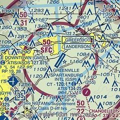
| Sectional chart |
|---|
|
CAUTION: Diagram may not be current
 Download PDF
of official airport diagram from the FAA
| Airport distance calculator |
|---|
|
|
| Sunrise and sunset |
|---|
|
Times for 05-Dec-2025
| | Local
(UTC-5) | | Zulu
(UTC) |
|---|
| Morning civil twilight | | 06:55 | | 11:55 |
| Sunrise | | 07:23 | | 12:23 |
| Sunset | | 17:16 | | 22:16 |
| Evening civil twilight | | 17:44 | | 22:44 |
|
| Current date and time |
|---|
| Zulu (UTC) | 05-Dec-2025 14:54:45 |
|---|
| Local (UTC-5) | 05-Dec-2025 09:54:45 |
|---|
|
| METAR |
|---|
| KGSP | 051425Z 02008KT 1 1/2SM -RA BR OVC005 03/03 A3008 RMK AO2 RAB1355 P0001 T00330028
|
KGMU
7nm SW | 051440Z 03008KT 2 1/2SM BR OVC005 04/03 A3007 RMK AO2 CIG 003V008 P0001 T00390033
|
KGYH
11nm SW | 051347Z 04011KT 2SM DZ BR OVC004 04/03 A3007
|
KSPA
16nm NE | 051435Z AUTO 02008KT 2 1/2SM DZ OVC004 03/02 A3007 RMK AO2 P0002
|
|
| TAF |
|---|
| KGSP | 051352Z 0514/0612 02008KT 5SM -RA BR OVC004 TEMPO 0514/0517 1 1/2SM -RA BR OVC002 FM051800 03005KT 6SM BR OVC005 FM060200 00000KT 2SM BR OVC003 FM060700 00000KT 1SM BR OVC002
|
KGMU
7nm SW | 051352Z 0514/0612 04009KT 5SM -RA BR OVC005 TEMPO 0514/0517 1 1/2SM -RA BR OVC002 FM051800 04005KT 6SM BR OVC005 FM060200 00000KT 3SM BR OVC003 FM060700 00000KT 1SM BR OVC002
|
|
| NOTAMs |
|---|
NOTAMs are issued by the DoD/FAA and will open in a separate window not controlled by AirNav.
|
|


