FAA INFORMATION EFFECTIVE 09 JULY 2026
Location
| FAA Identifier: | HAI |
| Lat/Long: | 41-57-35.0650N 085-35-35.0240W
41-57.584417N 085-35.583733W
41.9597403,-85.5930622
(estimated) |
| Elevation: | 822.7 ft. / 250.8 m (surveyed) |
| Variation: | 04W (2000) |
| From city: | 2 miles NE of THREE RIVERS, MI |
| Time zone: | UTC -4 (UTC -5 during Standard Time) |
| Zip code: | 49093 |
Airport Operations
| Airport use: | Open to the public |
| Activation date: | 12/1944 |
| Control tower: | no |
| ARTCC: | CHICAGO CENTER |
| FSS: | LANSING FLIGHT SERVICE STATION |
| NOTAMs facility: | HAI (NOTAM-D service available) |
| Attendance: | UNATNDD |
| Pattern altitude: | 1822.7 ft. MSL |
| Wind indicator: | lighted |
| Segmented circle: | yes |
| Lights: | ACTVT REIL RWY 09 & 27; PAPI RWY 09 & 27; MIRL RWY 05/23 & 09/27 - CTAF. |
| Beacon: | white-green (lighted land airport)
Operates sunset to sunrise. |
Airport Communications
| CTAF/UNICOM: | 122.8 |
| WX AWOS-3P: | 119.975 (269-273-6705) |
| GREAT LAKES APPROACH: | 121.2 |
| GREAT LAKES DEPARTURE: | 121.2 |
| WX AWOS-3P at IRS (11 nm SE): | 121.325 (269-659-8715) |
| WX ASOS at AZO (17 nm N): | PHONE 269-459-3391 |
- APCH/DEP SVC PRVDD BY CHICAGO ARTCC ON 127.55/307.175 (GOSHEN RCAG) WHEN GREAT LAKES APCH CTL CLSD.
Nearby radio navigation aids
| VOR radial/distance | | VOR name | | Freq | | Var |
|---|
| GIJr071/34.4 | | GIPPER VORTAC | | 115.40 | | 00E |
| NDB name | | Hdg/Dist | | Freq | | Var | | ID |
|---|
| AUSTN | | 198/10.7 | | 371 | | 03W | | AZ | .- --.. |
| STURGIS | | 325/11.3 | | 382 | | 04W | | IRS | .. .-. ... |
Airport Services
| Fuel available: | 100LL JET-A |
| Parking: | tiedowns |
| Airframe service: | MAJOR |
| Powerplant service: | MAJOR |
| Bottled oxygen: | NONE |
| Bulk oxygen: | NONE |
Runway Information
Runway 9/27
| Dimensions: | 4000 x 75 ft. / 1219 x 23 m |
| Surface: | asphalt, in good condition |
| Weight bearing capacity: | | Single wheel: | 26.0 | | Double wheel: | 30.0 |
|
| Runway edge lights: | medium intensity |
| RUNWAY 9 | | RUNWAY 27 |
| Latitude: | 41-57.626220N | | 41-57.629323N |
| Longitude: | 085-36.073525W | | 085-35.191103W |
| Elevation: | 819.9 ft. | | 822.4 ft. |
| Traffic pattern: | left | | left |
| Runway heading: | 094 magnetic, 090 true | | 274 magnetic, 270 true |
| Markings: | nonprecision, in good condition | | nonprecision, in good condition |
| Visual slope indicator: | 4-light PAPI on left (3.00 degrees glide path) | | 4-light PAPI on left (4.00 degrees glide path) |
| Runway end identifier lights: | yes | | yes |
| Touchdown point: | yes, no lights | | yes, no lights |
| Obstructions: | 90 ft. trees, 3778 ft. from runway, 39:1 slope to clear | | 75 ft. trees, 1442 ft. from runway, 17:1 slope to clear |
Runway 5/23
| Dimensions: | 2719 x 60 ft. / 829 x 18 m |
| Surface: | asphalt, in fair condition |
| Weight bearing capacity: | |
| Runway edge lights: | medium intensity |
| RUNWAY 5 | | RUNWAY 23 |
| Latitude: | 41-57.361435N | | 41-57.679807N |
| Longitude: | 085-35.723075W | | 085-35.301402W |
| Elevation: | 822.5 ft. | | 821.0 ft. |
| Traffic pattern: | left | | left |
| Runway heading: | 049 magnetic, 045 true | | 229 magnetic, 225 true |
| Markings: | nonprecision, in good condition | | nonprecision, in good condition |
| Touchdown point: | yes, no lights | | yes, no lights |
| Obstructions: | 16 ft. road, 450 ft. from runway, 150 ft. right of centerline, 15:1 slope to clear | | 13 ft. road, 275 ft. from runway, 130 ft. right of centerline, 5:1 slope to clear |
Airport Ownership and Management from official FAA records
| Ownership: | Publicly-owned |
| Owner: | CITY OF THREE RIVERS
MUNICIPAL BLDG, 333 W MICHIGAN AVE
THREE RIVERS, MI 49093-2193
Phone 269-273-1075 |
| Manager: | DAN MILLER
333 W MICHIGAN AVE
THREE RIVERS, MI 49093-2193
Phone 269-273-1845
CELL 269-506-3878. |
Additional Remarks
| - | ADMIN BLDG ACCESS, 5-3-2-1, OR 1-2-0-0. |
| - | FOR CD CTC GREAT LAKES APCH AT 269-459-3344, WHEN APCH CLSD CTC CHICAGO ARTCC AT 630-906-8921. |
| - | PSBL OF CROP IRRIGATION EQUIP OPERG NE APCH TO RWY 23. |
| - | RWY 23 15 FT VERT CLNC OVR ROAD IS WAIVED BY FAA. |
| - | RDO CTLD ACFT OPERATE .5 MI NW OF RWY 09. |
| - | RWY 5 15 FT VERT CLNC OVR ROAD WAIVED BY FAA (10/06/2009 ALP APVL LTR). |
| - | SNOW PLOWING SRY PRIORITY, CALL 269-273-1845 AMGR TO CFM CONDS. |
| - | DEER & LARGE BIRDS ON & INVOF ARPT. |
Instrument Procedures
NOTE: All procedures below are presented as PDF files. If you need a reader for these files, you should download the free Adobe Reader.NOT FOR NAVIGATION. Please procure official charts for flight.
FAA instrument procedures published for use from 09 July 2026 at 0901Z to 06 August 2026 at 0900Z.
IAPs - Instrument Approach Procedures |
|---|
| RNAV (GPS) RWY 27 | |
download (207KB) |
| NOTE: Special Alternate Minimums apply | |
download (139KB) |
| NOTE: Special Take-Off Minimums/Departure Procedures apply | |
download (355KB) |
Other nearby airports with instrument procedures:
KIRS - Kirsch Municipal Airport (11 nm SE)
KAZO - Kalamazoo/Battle Creek International Airport (17 nm N)
KEKM - Elkhart Municipal Airport (23 nm SW)
C91 - Dowagiac Municipal Airport (24 nm W)
KOEB - Branch County Memorial Airport (24 nm E)
|
|

Road maps at:
MapQuest
Bing
Google
| Aerial photo |
|---|
WARNING: Photo may not be current or correct
 Photo courtesy of Destination Flight, Inc.
Photo taken 01-Sep-2007
from the south looking north
Photo courtesy of Destination Flight, Inc.
Photo taken 01-Sep-2007
from the south looking north
Do you have a better or more recent aerial photo of Three Rivers Municipal/Dr Haines Airport that you would like to share? If so, please send us your photo.
|
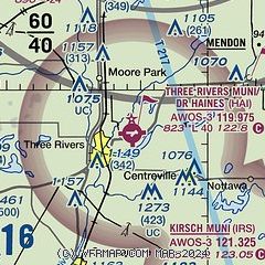
| Sectional chart |
|---|
|
CAUTION: Diagram may not be current

| Airport distance calculator |
|---|
|
|
| Sunrise and sunset |
|---|
|
Times for 29-Jul-2026
| | Local
(UTC-4) | | Zulu
(UTC) |
|---|
| Morning civil twilight | | 06:02 | | 10:02 |
| Sunrise | | 06:34 | | 10:34 |
| Sunset | | 21:04 | | 01:04 |
| Evening civil twilight | | 21:36 | | 01:36 |
|
| Current date and time |
|---|
| Zulu (UTC) | 29-Jul-2026 13:49:24 |
|---|
| Local (UTC-4) | 29-Jul-2026 09:49:24 |
|---|
|
| METAR |
|---|
| KHAI | 291335Z AUTO VRB03KT 10SM SCT050 20/16 A2998 RMK AO2
|
KIRS
12nm SE | 281735Z AUTO 01008KT 10SM SCT033 SCT039 26/20 A2980 RMK AO2
|
KAZO
17nm N | 291253Z 35005KT 10SM OVC046 19/14 A2998 RMK AO2 SLP147 T01940139
|
|
| TAF |
|---|
KAZO
17nm N | 291120Z 2912/3012 34004KT P6SM SKC FM291600 36008KT P6SM SCT040 FM300100 31005KT P6SM SKC
|
|
| NOTAMs |
|---|
NOTAMs are issued by the DoD/FAA and will open in a separate window not controlled by AirNav.
|
|


