FAA INFORMATION EFFECTIVE 09 JULY 2026
Location
| FAA Identifier: | HEF |
| Lat/Long: | 38-43-15.6890N 077-30-54.3770W
38-43.261483N 077-30.906283W
38.7210247,-77.5151047
(estimated) |
| Elevation: | 192.2 ft. / 58.6 m (surveyed) |
| Variation: | 10W (2000) |
| From city: | 28 miles WSW of WASHINGTON, DC |
| Time zone: | UTC -4 (UTC -5 during Standard Time) |
| Zip code: | 20110 |
Airport Operations
| Airport use: | Open to the public |
| Activation date: | 12/1964 |
| Control tower: | yes |
| ARTCC: | WASHINGTON CENTER |
| FSS: | LEESBURG FLIGHT SERVICE STATION |
| NOTAMs facility: | HEF (NOTAM-D service available) |
| Attendance: | 0630-2230 |
| Pattern altitude: | TPA - 1200 MSL SINGLE ENGINE & LGT TWIN ACFT; 1500 MSL MED TWIN & TURBOPROP ACFT; 1000 MSL HELICOPTER. |
| Wind indicator: | lighted |
| Segmented circle: | yes |
| Lights: | WHEN ATCT CLSD ACTVT MALSR RWY 16L; MALSF RWY 34R; REILS RWY 16R & 34L; HIRL RWY 16L/34R, MIRL RWY 16R/34L - CTAF. |
| Beacon: | white-green (lighted land airport)
Operates sunset to sunrise. |
| International operations: | customs landing rights airport |
Airport Communications
| CTAF: | 133.1 |
| ATIS: | 125.175 |
| WX AWOS-3PT: | PHONE 703-361-6160 |
| MANASSAS GROUND: | 121.8 [0630-2230] |
| MANASSAS TOWER: | 133.1 360.75 [0630-2230] |
| POTOMAC APPROACH: | 128.525 |
| POTOMAC DEPARTURE: | 128.525 |
| CLEARANCE DELIVERY: | 120.2 ;WHEN HEF TWR CLSD 120.2 |
| COATT STAR: | 128.525 |
| GABBE DP: | 128.525 |
| GIBBZ STAR: | 120.45 |
| HIICH DP: | 128.525 |
| HYPER STAR: | 133.0 |
| TIKEE STAR: | 120.45 |
| TRSTN STAR: | 126.75 |
| WX AWOS-3 at HWY (12 nm SW): | 120.350 (540-788-4078) |
| WX ASOS at IAD (14 nm N): | 134.85 (571-250-7817) |
| WX AWOS-3 at RMN (20 nm S): | 126.325 (540-657-8283) |
| WX AWOS-3 at CJR (20 nm SW): | 119.325 (540-727-0523) |
Nearby radio navigation aids
| VOR radial/distance | | VOR name | | Freq | | Var |
|---|
| AMLr198/13.0 | | ARMEL VOR/DME | | 113.50 | | 08W |
| CSNr080/17.1 | | CASANOVA VORTAC | | 116.30 | | 06W |
| DCAr259/23.9 | | WASHINGTON VOR/DME | | 111.00 | | 09W |
| BRVr351/24.3 | | BROOKE VORTAC | | 114.50 | | 09W |
| ADWr270/30.8 | | ANDREWS VORTAC | | 113.10 | | 10W |
| LDNr110/33.3 | | LINDEN VORTAC | | 114.30 | | 06W |
| NDB name | | Hdg/Dist | | Freq | | Var | | ID |
|---|
| GEORGETOWN | | 245/22.2 | | 323 | | 09W | | GTN | --. - -. |
| NAILR | | 059/24.3 | | 351 | | 10W | | MSQ | -- ... --.- |
| SHANNON | | 004/27.4 | | 237 | | 10W | | EZF | . --.. ..-. |
Airport Services
| Fuel available: | 100LL JET-A |
| Parking: | hangars and tiedowns |
| Airframe service: | MAJOR |
| Powerplant service: | MAJOR |
| Bottled oxygen: | LOW |
| Bulk oxygen: | HIGH/LOW |
Runway Information
Runway 16L/34R
| Dimensions: | 6200 x 100 ft. / 1890 x 30 m |
| Surface: | asphalt/grooved, in fair condition |
| Weight bearing capacity: | | Single wheel: | 50.0 | | Double wheel: | 140.0 |
|
| Runway edge lights: | high intensity |
| RUNWAY 16L | | RUNWAY 34R |
| Latitude: | 38-43.661935N | | 38-42.771970N |
| Longitude: | 077-31.126465W | | 077-30.486700W |
| Elevation: | 192.2 ft. | | 177.4 ft. |
| Traffic pattern: | left | | right |
| Runway heading: | 161 magnetic, 151 true | | 341 magnetic, 331 true |
| Markings: | precision, in good condition | | nonprecision, in good condition |
| Visual slope indicator: | 4-light PAPI on left (3.00 degrees glide path) | | 4-light PAPI on left (3.00 degrees glide path) |
| Approach lights: | MALSR: 1,400 foot medium intensity approach lighting system with runway alignment indicator lights | | MALSF: 1,400 foot medium intensity approach lighting system with sequenced flashers |
| Runway end identifier lights: | no | | no |
| Touchdown point: | yes, no lights | | yes, no lights |
| Instrument approach: | LOC/GS | | |
| Obstructions: | 55 ft. trees, 1822 ft. from runway, 358 ft. right of centerline, 29:1 slope to clear | | 63 ft. trees, 1794 ft. from runway, 329 ft. right of centerline, 25:1 slope to clear |
Runway 16R/34L
| Dimensions: | 3715 x 75 ft. / 1132 x 23 m |
| Surface: | asphalt, in excellent condition |
| Weight bearing capacity: | |
| Runway edge lights: | medium intensity |
| RUNWAY 16R | | RUNWAY 34L |
| Latitude: | 38-43.602375N | | 38-43.069187N |
| Longitude: | 077-31.264473W | | 077-30.881035W |
| Elevation: | 185.7 ft. | | 175.1 ft. |
| Traffic pattern: | right | | left |
| Runway heading: | 161 magnetic, 151 true | | 341 magnetic, 331 true |
| Markings: | nonprecision, in good condition | | nonprecision, in good condition |
| Visual slope indicator: | 2-light PAPI on left (3.00 degrees glide path) | | 2-light PAPI on left (3.00 degrees glide path) |
| Runway end identifier lights: | yes | | yes |
| Touchdown point: | yes, no lights | | yes, no lights |
| Obstructions: | 64 ft. tree, 1782 ft. from runway, 150 ft. left of centerline, 24:1 slope to clear | | 39 ft. trees, 849 ft. from runway, 10 ft. left of centerline, 16:1 slope to clear |
Airport Ownership and Management from official FAA records
| Ownership: | Publicly-owned |
| Owner: | CITY OF MANASSAS
10600 HARRY J. PARRISH BOULEVARD
MANASSAS, VA 20110
Phone 703-361-1882 |
| Manager: | JUAN RIVERA
10600 HARRY J. PARRISH BOULEVARD
MANASSAS, VA 20110
Phone 703-361-1882 |
Additional Remarks
| - | BIRDS & DEER ON & INVOF ARPT. |
| - | HELICOPTER OPS OVER RESIDENTIAL AREAS BLW 1000 FT SHOULD BE AVOIDED; CTC AMGR 703-361-1882 FOR INFO. |
| - | US CUSTOMS AVBL MON-SUN 1000-0400Z. CALL COMMAND CENTER 703-661-2800 FOR APNTMT. 24 HR NOTICE RQRD. ALL WKEND FLIGHTS MUST BE ARNGD BFR 1700 LOCAL ON FRI BFR. |
| - | FOR CD WHEN ATCT IS CLSD CTC POTOMAC APCH AT 866-709-4993. |
| - | TRML APN FOR TSNT AND US CUST PRKG. |
| - | TWY B SAFETY AREA WID 44 FT LATERALLY EAST SIDE FM TWY E TO TWY G. |
| - | ARFF INDEX B SVCS AVBL 0700-1900 DAILY, PPR 48HRS FOR ARFF INDEX C OR STANDBY SVC OUTSIDE OPRG HRS. FEE FOR ADDNL SVC. CALL ARFF AT 703-587-6302. |
Instrument Procedures
NOTE: All procedures below are presented as PDF files. If you need a reader for these files, you should download the free Adobe Reader.NOT FOR NAVIGATION. Please procure official charts for flight.
FAA instrument procedures published for use from 09 July 2026 at 0901Z to 06 August 2026 at 0900Z.
STARs - Standard Terminal Arrivals |
|---|
| GIBBZ SIX (RNAV) **NEW** | |
2 pages:
[1] [2] (562KB) |
| HYPER ONE (RNAV) **NEW** | |
2 pages:
[1] [2] (401KB) |
| HYPER ONE (RNAV), CONT.2 **NEW** | |
download (220KB) |
| PRIVO THREE **CHANGED** | |
2 pages:
[1] [2] (266KB) |
| PRTZL TWO (RNAV) **NEW** | |
2 pages:
[1] [2] (335KB) |
| PRTZL TWO (RNAV), CONT.2 **NEW** | |
download (217KB) |
| TIKEE FOUR (RNAV) **CHANGED** | |
download (221KB) |
| TRSTN FOUR (RNAV) **CHANGED** | |
2 pages:
[1] [2] (318KB) |
| WAYNZ TWO (RNAV) **NEW** | |
2 pages:
[1] [2] (427KB) |
IAPs - Instrument Approach Procedures |
|---|
| ILS OR LOC RWY 16L **CHANGED** | |
download (237KB) |
| RNAV (GPS) RWY 16L **CHANGED** | |
download (233KB) |
| RNAV (GPS) RWY 16R **CHANGED** | |
download (233KB) |
| RNAV (GPS) RWY 34L **CHANGED** | |
download (250KB) |
| RNAV (GPS) RWY 34R **CHANGED** | |
download (220KB) |
| NOTE: Special Alternate Minimums apply **CHANGED** | |
download (165KB) |
Departure Procedures |
|---|
| ARSENAL FIVE **CHANGED** | |
2 pages:
[1] [2] (418KB) |
| GABBE THREE (RNAV) **CHANGED** | |
2 pages:
[1] [2] (298KB) |
| HIICH TWO (RNAV) **CHANGED** | |
2 pages:
[1] [2] (294KB) |
| NOTE: Special Take-Off Minimums/Departure Procedures apply **CHANGED** | |
download (369KB) |
Other nearby airports with instrument procedures:
KHWY - Warrenton/Fauquier Airport (12 nm SW)
KIAD - Washington Dulles International Airport (14 nm N)
KDAA - Davison Army Airfield (16 nm E)
KNYG - Quantico Marine Corps Air Facility (Turner Field) (16 nm SE)
KRMN - Washington Executive/Stafford Regional Airport (20 nm S)
KCJR - Culpeper Regional Airport (20 nm SW)
|
|

Road maps at:
MapQuest
Bing
Google
| Aerial photo |
|---|
WARNING: Photo may not be current or correct
 Taken in May 2021
looking northwest.
Taken in May 2021
looking northwest.
Do you have a better or more recent aerial photo of Washington Manassas Airport/Harry P Davis Field that you would like to share? If so, please send us your photo.
|
| Sectional chart |
|---|
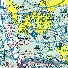
|
CAUTION: Diagram may not be current
 Download PDF
of official airport diagram from the FAA
| Airport distance calculator |
|---|
|
|
| Sunrise and sunset |
|---|
|
Times for 26-Jul-2026
| | Local
(UTC-4) | | Zulu
(UTC) |
|---|
| Morning civil twilight | | 05:37 | | 09:37 |
| Sunrise | | 06:07 | | 10:07 |
| Sunset | | 20:26 | | 00:26 |
| Evening civil twilight | | 20:56 | | 00:56 |
|
| Current date and time |
|---|
| Zulu (UTC) | 26-Jul-2026 16:18:31 |
|---|
| Local (UTC-4) | 26-Jul-2026 12:18:31 |
|---|
|
| METAR |
|---|
| KHEF | 261556Z VRB03KT 10SM FEW022 SCT055 27/20 A2994 RMK AO2 SLP141 T02670200 $
|
KHWY
12nm SW | 261515Z AUTO 00000KT 10SM SCT019 27/19 A2995 RMK AO2 T02660189
|
KIAD
13nm N | 261552Z VRB05KT 10SM BKN037 26/19 A2993 RMK AO2 SLP132 T02610194 $
|
KDAA
16nm E | 261555Z AUTO 00000KT 10SM BKN032 BKN039 27/19 A2990 RMK AO2 SLP128 T02670190 $
|
KNYG
17nm SE | 261556Z AUTO 15005KT FEW035 27/19 A2994 RMK AO2 SLP138 T02720189 PWINO $
|
KRMN
20nm S | 261515Z AUTO 00000KT 10SM BKN027 27/19 A2994 RMK AO2 T02690186
|
KCJR
20nm SW | 261515Z AUTO 00000KT 10SM CLR 26/20 A2995 RMK AO2 T02610195
|
|
| TAF |
|---|
KIAD
13nm N | 261124Z 2612/2718 17004KT P6SM SCT050 PROB30 2701/2705 6SM -TSRA BKN060CB FM270700 VRB03KT 6SM BR FEW005 FEW020 FM271400 19004KT P6SM OVC100
|
|
| NOTAMs |
|---|
NOTAMs are issued by the DoD/FAA and will open in a separate window not controlled by AirNav.
|
|


