FAA INFORMATION EFFECTIVE 27 NOVEMBER 2025
Location
| FAA Identifier: | DAA |
| Lat/Long: | 38-42-53.7220N 077-10-51.2190W
38-42.895367N 077-10.853650W
38.7149228,-77.1808942
(estimated) |
| Elevation: | 73.5 ft. / 22.4 m (surveyed) |
| Variation: | 09W (1985) |
| From city: | 3 miles NW of FORT BELVOIR, VA |
| Time zone: | UTC -5 (UTC -4 during Daylight Saving Time) |
| Zip code: | 22060 |
Airport Operations
| Airport use: | Private use. Permission required prior to landing |
| Control tower: | yes |
| ARTCC: | WASHINGTON CENTER |
| FSS: | LEESBURG FLIGHT SERVICE STATION |
| NOTAMs facility: | DCA (NOTAM-D service available) |
| Attendance: | CONTINUOUS |
| Pattern altitude: | 1173.5 ft. MSL |
| Segmented circle: | no |
| Lights: | AVBL 0230-1100Z++ MON-FRI AND 24 HRS ON WKNDS AND HOLS. WHEN TWR CLSD HIRL RWY 14-32 SET TO PCL. TO ACTVT & INCR INTS MALSF RWY 32; PAPI RWY 14 & 32 - CTAF. |
| Beacon: | white-white-green (lighted military airport)
Operates sunset to sunrise. |
Airport Communications
| CTAF: | 124.275 |
| ATIS: | 128.175 |
| DAVIDSON GROUND: | 121.9 351.8 [1100-0230Z++ MON-FRI EXC HOL.] |
| DAVIDSON TOWER: | 124.275 229.4 241.0 [1100-0230Z++ MON-FRI EXC HOL.] |
| POTOMAC APPROACH: | 118.95 124.7 |
| POTOMAC DEPARTURE: | 118.95 124.7 |
| CLEARANCE DELIVERY: | 351.8 |
| ARNG OPS: | 52.75 |
| ASR/PAR: | 118.85 119.95 248.5 265.6 |
| BASE OPS: | 139.4 |
| CLTCH DP: | 118.95 |
| EMERG: | 121.5 243.0 |
| FRDMM STAR: | 118.675 |
| IRONS STAR: | 126.4 |
| JDUBB DP: | 118.95 |
| NUMMY STAR: | 118.675 |
| PMSV METRO: | 139.4 |
| PTD: | 139.4 |
| SCRAM DP: | 118.95 |
| TIKEE STAR: | 120.45 |
| TRUPS STAR: | 118.675 |
| WX ASOS at DCA (11 nm NE): | 132.65 (276-200-0159) |
| WX AWOS-3PT at HEF (16 nm W): | PHONE 703-361-6160 |
| WX ASOS at IAD (19 nm NW): | 134.85 (571-250-7817) |
- VIP ARR CTC BASE OPS 15 MIN PRIOR TO LDG.
Nearby radio navigation aids
| VOR radial/distance | | VOR name | | Freq | | Var |
|---|
| DCAr227/11.0 | | WASHINGTON VOR/DME | | 111.00 | | 09W |
| ADWr259/15.7 | | ANDREWS VORTAC | | 113.10 | | 10W |
| AMLr143/18.8 | | ARMEL VOR/DME | | 113.50 | | 08W |
| BRVr029/24.1 | | BROOKE VORTAC | | 114.50 | | 09W |
| CSNr088/32.4 | | CASANOVA VORTAC | | 116.30 | | 06W |
| BALr233/36.6 | | BALTIMORE VORTAC | | 115.10 | | 11W |
| NDB name | | Hdg/Dist | | Freq | | Var | | ID |
|---|
| OXONN | | 258/7.8 | | 332 | | 11W | | VQK | ...- --.- -.- |
| GEORGETOWN | | 201/13.2 | | 323 | | 09W | | GTN | --. - -. |
| SHANNON | | 035/29.7 | | 237 | | 10W | | EZF | . --.. ..-. |
| NAILR | | 075/37.4 | | 351 | | 10W | | MSQ | -- ... --.- |
| ELLICOTT | | 220/39.2 | | 371 | | 11W | | FND | ..-. -. -.. |
Airport Services
Runway Information
Runway 14/32
| Dimensions: | 5421 x 75 ft. / 1652 x 23 m |
| Surface: | asphalt |
| Weight bearing capacity: | |
| Runway edge lights: | high intensity |
| RUNWAY 14 | | RUNWAY 32 |
| Latitude: | 38-43.202500N | | 38-42.588200N |
| Longitude: | 077-11.267333W | | 077-10.440033W |
| Elevation: | 48.8 ft. | | 73.4 ft. |
| Traffic pattern: | left | | left |
| Runway heading: | 142 magnetic, 133 true | | 322 magnetic, 313 true |
| Displaced threshold: | 491 ft. | | 892 ft. |
| Markings: | precision, in good condition | | precision, in good condition |
| Visual slope indicator: | 4-light PAPI on left (3.00 degrees glide path) | | 4-light PAPI on right (3.00 degrees glide path) |
| RVR equipment: | rollout | | touchdown |
| Approach lights: | NATO STD APPROACH LGTS (BP). | | MALSF: 1,400 foot medium intensity approach lighting system with sequenced flashers |
| Runway end identifier lights: | no | | no |
| Touchdown point: | yes, no lights | | yes, no lights |
| Instrument approach: | | | ILS/DME |
Helipad H1
| Dimensions: | 50 x 50 ft. / 15 x 15 m |
| Surface: | concrete |
| Latitude: | 38-43.020000N | | |
| Longitude: | 077-10.789833W | | |
| Elevation: | 40.0 ft. | | |
| Traffic pattern: | left | | left |
Airport Ownership and Management from official FAA records
| Ownership: | U.S. Army |
| Owner: | DAVISON ARMY AIRFIELD
US ARMY ATCA-ASO, 6970 BRITTON DR
FT BELVIOR, VA 22060 |
| Manager: | Phone 703-664-1201 |
Additional Remarks
| - | FUEL: FUEL - A++ (MIL); AVBL 1200-0300Z++ MON-FRI. |
| - | MISC-AERODROME BEACON LOCATED 4600 FT E-NE OF AFLD ON TOP OF DLA BLDG. |
| - | RSTD: RWY 14 PAPI ARE NON-STANDARD. VFR USE ONLY. |
| - | FOR CD WHEN ATCT IS CLSD CTC POTOMAC APCH AT 866-599-3874. |
| - | RSTD: TWY G, H, AND J CLSD FOR NIGHT AND IFR OPS DUE TO BEING UNLIT. |
| - | RSTD: HELIPAD 14/32 IS 50 FT BY 50 FT WIDE. LMTD TO H-60 AND SMALLER ACFT OPS. |
| - | HAZARDS: RWY 14 INBRD (INGROUND) THR LGTS ARE REMOVED. |
| - | RSTD: HELIPAD 14/32 CLSD FOR NIGHT AND IFR OPS DUE TO BEING UNLIT. |
| - | OIL: 0-123-128-148-156. |
| - | OFFL BUS ONLY. PPR 24 HR NOTICE FOR ALL NON DAA BASED ACFT, CTC BASE OPS 1100-0500Z++ MON-FRI 1200-2100Z++ SAT-SUN, C571-515-4226/4228/4424. |
| - | RSTD: 24 HR PPR NVESD RAMP, DSN 656-7675/7676, C703-806-7675/7676. |
| - | CAUTON: EXP SHEAR/CROSSWIND SHIFT TDZ RWY 32 DUR SW-NW WIND. BIRD AND DEER HAZ. |
| - | TFC PAT: F/W R/W SW 1500 FT, R/W/NE 1100 FT. |
| - | NS ABTMT: TWR WILL ADVS OF RSTD TO ENG RUN-UP, TKOF AND LDG BTN 0300-1300Z++ MON-SAT;2200-1700Z++ SUN AND HOL. |
| - | MISC: WITH CTL TWR/OPR APV, DEP ACFT MAY USE RWY APCH END OVRN FOR TKOF ROLL. WX FCST 1100-0230Z++ MON-FRI, EXC HOL, OT REMOTE BRIEFING SVC AVBL 15TH OWS, SCOTT AFB DSN 576-9755, C618-256-9755, FAX EXTN 4855 0R HTTP://OWS.SCOTT.AF.MIL. SEE VFR-S FOR PENTAGON HELIPORT. |
| - | ARNG: OPR 24/7. 24 HR PPR FOR TRAN ACFT, DSN 656-7092/7690, C703-806-7092/7690 FAX 7298. |
Instrument Procedures
NOTE: All procedures below are presented as PDF files. If you need a reader for these files, you should download the free Adobe Reader.NOT FOR NAVIGATION. Please procure official charts for flight.
FAA instrument procedures published for use from 27 November 2025 at 0901Z to 25 December 2025 at 0900Z.
STARs - Standard Terminal Arrivals |
|---|
| FRDMM SIX (RNAV) | |
2 pages:
[1] [2] (518KB) |
| NUMMY THREE | |
download (250KB) |
| TIKEE FOUR (RNAV) | |
download (215KB) |
| TRUPS FIVE (RNAV) | |
2 pages:
[1] [2] (548KB) |
IAPs - Instrument Approach Procedures |
|---|
| ILS OR LOC RWY 32 | |
download (167KB) |
| RNAV (GPS) RWY 14 | |
download (73KB) |
| RNAV (GPS) RWY 32 | |
download (79KB) |
Departure Procedures |
|---|
| CLTCH THREE (RNAV) | |
download (171KB) |
| JDUBB FOUR (RNAV) | |
download (170KB) |
| SCRAM SIX (RNAV) | |
download (157KB) |
| NOTE: Special Take-Off Minimums/Departure Procedures apply | |
download (355KB) |
Other nearby airports with instrument procedures:
2W5 - Maryland Airport (9 nm SE)
KDCA - Ronald Reagan Washington National Airport (11 nm NE)
KVKX - Potomac Airfield (11 nm E)
KNYG - Quantico Marine Corps Air Facility (Turner Field) (14 nm SW)
KHEF - Manassas Regional Airport/Harry P. Davis Field (16 nm W)
KADW - Joint Base Andrews (16 nm E)
KIAD - Washington Dulles International Airport (19 nm NW)
|
|

Road maps at:
MapQuest
Bing
Google
| Aerial photo |
|---|
WARNING: Photo may not be current or correct
 Photo by Jeff Long, SkyFocal.com
Photo taken 05-Nov-2011
looking northwest.
Photo by Jeff Long, SkyFocal.com
Photo taken 05-Nov-2011
looking northwest.
Do you have a better or more recent aerial photo of Davison Army Airfield that you would like to share? If so, please send us your photo.
|
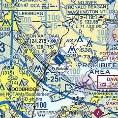
| Sectional chart |
|---|
|
| Airport distance calculator |
|---|
|
|
| Sunrise and sunset |
|---|
|
Times for 08-Dec-2025
| | Local
(UTC-5) | | Zulu
(UTC) |
|---|
| Morning civil twilight | | 06:46 | | 11:46 |
| Sunrise | | 07:15 | | 12:15 |
| Sunset | | 16:46 | | 21:46 |
| Evening civil twilight | | 17:16 | | 22:16 |
|
| Current date and time |
|---|
| Zulu (UTC) | 08-Dec-2025 17:17:17 |
|---|
| Local (UTC-5) | 08-Dec-2025 12:17:17 |
|---|
|
| METAR |
|---|
| KDAA | 081555Z AUTO 03007KT 10SM OVC060 02/M13 A3020 RMK AO2 SLP230 T00181128 $
|
KDCA
11nm NE | 081652Z 03015G24KT 10SM SCT090 OVC250 02/M12 A3021 RMK AO2 SLP230 T00171117 $
|
KNYG
14nm S | 081656Z 02012KT 7SM BKN075 OVC090 02/M11 A3023 RMK AO2 SLP236 T00221106
|
KHEF
16nm W | 081656Z 03011G18KT 10SM OVC080 01/M10 A3022 RMK AO2 SLP241 T00111100 FZRANO $
|
KADW
16nm NE | 081655Z 03017KT 10SM BKN160 01/M12 A3019 RMK AO2A SLP233 T00111120 $
|
KIAD
18nm NW | 081652Z 01012KT 10SM FEW085 01/M11 A3021 RMK AO2 SLP235 T00061111 $
|
|
| TAF |
|---|
| KDAA | 081300Z 0813/0919 36007KT 9999 FEW030 BKN050 OVC120 520105 620507 QNH3182INS TEMPO 0814/0819 36010G15KT 4800 -RASN BKN030 OVC050 BECMG 0818/0819 02015G25KT 9999 BKN070 OVC120 520009 620705 QNH3022INS BECMG 0822/0823 03012KT 9999 NSW SCT120 QNH3025INS BECMG 0907/0908 VRB05KT 9999 SKC QNH3024INS BECMG 0914/0915 VRB06KT 9999 OVC040 QNH3024INS TX02/0813Z TNM04/0911Z
|
KDCA
11nm NE | 081503Z 0815/0918 03014G22KT P6SM FEW040 OVC080 FM082300 03010KT P6SM SCT070 OVC120 FM090500 00000KT P6SM FEW060 FEW150 FM091600 18006KT P6SM FEW150
|
KNYG
14nm S | 0815/0915 02012G20KT 9999 FEW040 OVC070 QNH3021INS BECMG 0901/0903 02009KT 9999 BKN060 QNH3023INS TX02/0815Z TNM03/0911Z
|
KADW
16nm NE | 080900Z 0809/0915 01007KT 9999 FEW100 QNH3011INS BECMG 0810/0811 02012G21KT 9999 BKN060 620606 QNH3011INS TEMPO 0811/0814 02015G25KT BECMG 0814/0815 03012G18KT 9999 VCSH FEW030 BKN080 QNH3020INS BECMG 0822/0823 03012KT 9999 NSW SCT120 QNH3025INS BECMG 0907/0908 VRB05KT 9999 SKC QNH3024INS BECMG 0914/0915 13003KT 9999 OVC040 QNH3024INS TXM01/0809Z TNM07/0909Z
|
KIAD
18nm NW | 081503Z 0815/0918 02012G21KT P6SM OVC080 FM082300 02007KT P6SM SCT060 OVC100 FM090500 00000KT P6SM FEW060 FEW100 FM091600 19006KT P6SM SCT150
|
|
| NOTAMs |
|---|
NOTAMs are issued by the DoD/FAA and will open in a separate window not controlled by AirNav.
|
|

