FAA INFORMATION EFFECTIVE 11 JUNE 2026
Location
| FAA Identifier: | 2W5 |
| Lat/Long: | 38-35-49.3750N 077-04-20.8500W
38-35.822917N 077-04.347500W
38.5970486,-77.0724583
(estimated) |
| Elevation: | 175 ft. / 53 m (estimated) |
| Variation: | 09W (1985) |
| From city: | 4 miles E of INDIAN HEAD, MD |
| Time zone: | UTC -4 (UTC -5 during Standard Time) |
| Zip code: | 20646 |
Airport Operations
| Airport use: | Open to the public |
| Activation date: | 09/1945 |
| Control tower: | no |
| ARTCC: | WASHINGTON CENTER |
| FSS: | LEESBURG FLIGHT SERVICE STATION |
| NOTAMs facility: | DCA (NOTAM-D service available) |
| Attendance: | MON-SUN 0900-1800
UNATNDD THANKSGIVING, CHRISTMAS AND NEW YEARS DAYS. |
| Pattern altitude: | 1005 ft. MSL |
| Wind indicator: | yes |
| Segmented circle: | no |
| Lights: | ACTVT REIL RWY 02; PAPI RWY 02; MIRL RWY 02/20 - CTAF. ARPT DEACTIVATES PAPI RWY 02 WHEN WINDS FAVOR RWY 20. |
| Beacon: | white-green (lighted land airport)
Operates sunset to sunrise. |
Airport Communications
| CTAF/UNICOM: | 122.7 |
| POTOMAC APPROACH: | 124.7 ;DC SFRA 118.95 ;DC SFRA |
| POTOMAC DEPARTURE: | 124.7 ;DC SFRA 118.95 ;DC SFRA |
| IRONS STAR: | 126.4 |
| TIKEE STAR: | 120.45 |
| WX ASOS at DCA (15 nm N): | 132.65 (276-200-0159) |
Nearby radio navigation aids
| VOR radial/distance | | VOR name | | Freq | | Var |
|---|
| DCAr195/15.8 | | WASHINGTON VOR/DME | | 111.00 | | 09W |
| ADWr227/15.9 | | ANDREWS VORTAC | | 113.10 | | 10W |
| BRVr049/20.5 | | BROOKE VORTAC | | 114.50 | | 09W |
| AMLr146/27.4 | | ARMEL VOR/DME | | 113.50 | | 08W |
| CSNr100/37.3 | | CASANOVA VORTAC | | 116.30 | | 06W |
| BALr220/39.4 | | BALTIMORE VORTAC | | 115.10 | | 11W |
| NDB name | | Hdg/Dist | | Freq | | Var | | ID |
|---|
| OXONN | | 203/10.4 | | 332 | | 11W | | VQK | ...- --.- -.- |
| GEORGETOWN | | 182/20.1 | | 323 | | 09W | | GTN | --. - -. |
| SHANNON | | 052/26.6 | | 237 | | 10W | | EZF | . --.. ..-. |
Airport Services
| Fuel available: | 100LL JET-A |
| Parking: | tiedowns |
| Airframe service: | MINOR |
| Powerplant service: | MINOR |
| Bottled oxygen: | NONE |
| Bulk oxygen: | NONE |
Runway Information
Runway 2/20
| Dimensions: | 3740 x 75 ft. / 1140 x 23 m |
| Surface: | asphalt, in good condition |
| Runway edge lights: | medium intensity |
| RUNWAY 2 | | RUNWAY 20 |
| Latitude: | 38-35.515833N | | 38-36.130000N |
| Longitude: | 077-04.379333W | | 077-04.315667W |
| Elevation: | 156.1 ft. | | 175.0 ft. |
| Traffic pattern: | left | | left |
| Runway heading: | 014 magnetic, 005 true | | 194 magnetic, 185 true |
| Markings: | nonprecision, in good condition | | basic, in good condition |
| Visual slope indicator: | 4-light PAPI on left (3.00 degrees glide path) | | |
| Runway end identifier lights: | yes | | |
| Touchdown point: | yes, no lights | | yes, no lights |
| Obstructions: | 85 ft. trees, 2236 ft. from runway, 195 ft. left of centerline, 23:1 slope to clear | | 67 ft. trees, 1712 ft. from runway, 240 ft. left of centerline, 22:1 slope to clear |
Airport Ownership and Management from official FAA records
| Ownership: | Privately-owned |
| Owner: | PSM AVIATION LLC
3900 LIVINGSTON RD,
INDIAN HEAD, MD 20640
Phone 301-283-6202 |
| Manager: | SHEEL PATEL
3900 LIVINGSTON RD
INDIAN HEAD, MD 20640
Phone 301-283-6202 |
Additional Remarks
| - | BIRDS & WILDLIFE ON & INVOF ARPT. |
| - | FOR CD CTC POTOMAC APCH AT 866-599-3874. |
Instrument Procedures
NOTE: All procedures below are presented as PDF files. If you need a reader for these files, you should download the free Adobe Reader.NOT FOR NAVIGATION. Please procure official charts for flight.
FAA instrument procedures published for use from 11 June 2026 at 0901Z to 09 July 2026 at 0900z.
STARs - Standard Terminal Arrivals |
|---|
| TIKEE FOUR (RNAV) **NEW** | |
download (219KB) |
IAPs - Instrument Approach Procedures |
|---|
| RNAV (GPS) RWY 02 | |
download (180KB) |
| NOTE: Special Take-Off Minimums/Departure Procedures apply | |
download |
Other nearby airports with instrument procedures:
KDAA - Davison Army Airfield (9 nm NW)
KVKX - Potomac Airfield (11 nm NE)
KNYG - Quantico Marine Corps Air Facility (Turner Field) (12 nm SW)
KDCA - Ronald Reagan Washington National Airport (15 nm N)
KADW - Joint Base Andrews (16 nm NE)
|
|

Road maps at:
MapQuest
Bing
Google
| Aerial photo |
|---|
WARNING: Photo may not be current or correct
 Photo by Matt Beyer
Photo taken 01-Jul-2020
looking south.
Photo by Matt Beyer
Photo taken 01-Jul-2020
looking south.
Do you have a better or more recent aerial photo of Maryland Airport that you would like to share? If so, please send us your photo.
|
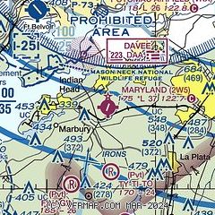
| Sectional chart |
|---|
|
| Airport distance calculator |
|---|
|
|
| Sunrise and sunset |
|---|
|
Times for 08-Jul-2026
| | Local
(UTC-4) | | Zulu
(UTC) |
|---|
| Morning civil twilight | | 05:21 | | 09:21 |
| Sunrise | | 05:52 | | 09:52 |
| Sunset | | 20:34 | | 00:34 |
| Evening civil twilight | | 21:06 | | 01:06 |
|
| Current date and time |
|---|
| Zulu (UTC) | 08-Jul-2026 10:18:04 |
|---|
| Local (UTC-4) | 08-Jul-2026 06:18:04 |
|---|
|
| METAR |
|---|
KDAA
8nm NW | 080915Z AUTO 00000KT 10SM BKN014 OVC020 24/22 A2999 RMK AO2 CIG 014V020 BKN V SCT SLP158 $
|
KNYG
11nm SW | 080956Z AUTO OVC021 24/22 A3003 RMK AO2 SLP169 T02440222 PWINO
|
KDCA
15nm N | 080952Z 07009KT 7SM OVC013 24/21 A3003 RMK AO2 SLP167 T02390211
|
KADW
16nm NE | 080925Z 06005KT 10SM OVC015 24/21 A3001 RMK AO2A CIG 012 RWY01L SLP167 $
|
|
| TAF |
|---|
KDAA
8nm NW | 072000Z 0720/0902 VRB06KT 9999 SCT030 BKN250 QNH2995INS TEMPO 0721/0801 VRB15G25KT 4800 -TSRA BKN025CB BECMG 0800/0801 VRB03KT 9999 OVC025 QNH3000INS BECMG 0806/0807 06006KT 9999 BKN010 OVC020 QNH2998INS BECMG 0809/0810 07006KT 9999 VCSH BKN008 OVC015 QNH2998INS BECMG 0814/0815 08006KT 8000 -SHRA SCT010 OVC015 QNH3002INS TX29/0721Z TN23/0810Z LAST NO AMDS AFT 0801 NEXT 0812
|
KNYG
11nm SW | 072100Z 0721/0821 08009G20KT 4800 SHRA OVC030CB QNH2990INS FM080030 07009KT 6000 SHRA BR BKN015 OVC020 QNH2993INS BECMG 0809/0811 08003KT 6000 SHRA BR OVC010 QNH2994INS TX30/0721Z TN23/0810Z
|
KDCA
15nm N | 080538Z 0806/0912 08008KT P6SM OVC025 FM080700 05005KT P6SM BKN008 OVC015 FM081400 09005KT P6SM SCT008 BKN015 FM082000 14004KT P6SM SCT020 BKN035 FM082300 17004KT P6SM FEW035 SCT050 FM090300 17003KT P6SM FEW020 BKN035 FM090900 00000KT P6SM SCT015 BKN020
|
KADW
16nm NE | 080100Z 0801/0907 VRB05KT 9999 BKN050 OVC100 QNH2996INS BECMG 0802/0803 09005KT 9999 VCSH OVC020 QNH2998INS BECMG 0804/0805 07006KT 9000 -SHRA BKN015 OVC020 QNH2998INS BECMG 0808/0809 05003KT 8000 BR BKN008 OVC020 QNH2999INS BECMG 0811/0812 04005KT 9000 BR BKN020 OVC040 QNH3000INS BECMG 0814/0815 08006KT 9999 NSW BKN025 QNH3000INS BECMG 0818/0819 VRB03KT 9999 BKN035 QNH2999INS BECMG 0821/0822 VRB05KT 9999 SCT035 QNH2995INS BECMG 0901/0902 16006KT 9999 BKN035 QNH2995INS BECMG 0906/0907 18010KT 99
|
|
| NOTAMs |
|---|
NOTAMs are issued by the DoD/FAA and will open in a separate window not controlled by AirNav.
|
|

