FAA INFORMATION EFFECTIVE 30 OCTOBER 2025
Location
| FAA Identifier: | HYR |
| Lat/Long: | 46-01-30.9579N 091-26-39.3539W
46-01.515965N 091-26.655898W
46.0252661,-91.4442650
(estimated) |
| Elevation: | 1216 ft. / 370.6 m (surveyed) |
| Variation: | 00E (2000) |
| From city: | 2 miles NE of HAYWARD, WI |
| Time zone: | UTC -5 (UTC -6 during Standard Time) |
| Zip code: | 54843 |
Airport Operations
| Airport use: | Open to the public |
| Control tower: | no |
| ARTCC: | MINNEAPOLIS CENTER |
| FSS: | GREEN BAY FLIGHT SERVICE STATION |
| NOTAMs facility: | HYR (NOTAM-D service available) |
| Attendance: | MAY-OCT 0800-1800, NOV - APR 0800 -1700 |
| Wind indicator: | lighted |
| Segmented circle: | no |
| Lights: | ACTVT MALSR RWY 21; REIL RWY 03; PAPI RWY 03 & 21; HIRL RWY 03/21 - CTAF. SS-SR HIRL RWY 03/21 PRESET TO LOW; TO INCR INTST - CTAF. |
| Beacon: | white-green (lighted land airport)
Operates sunset to sunrise. |
Airport Communications
| CTAF/UNICOM: | 122.8 |
| WX ASOS: | 118.4 (715-634-6138) |
- APCH/DEP SVC PRVDD BY MINNEAPOLIS ARTCC ON FREQS 126.45/276.4 (HAYWARD RCAG).
Airport Services
| Fuel available: | 100LL JET-A+ |
| Parking: | hangars and tiedowns |
| Airframe service: | NONE |
| Powerplant service: | NONE |
| Bottled oxygen: | NONE |
| Bulk oxygen: | NONE |
Runway Information
Runway 3/21
| Dimensions: | 5002 x 100 ft. / 1525 x 30 m |
| Surface: | asphalt/grooved, in excellent condition |
| Weight bearing capacity: | | Single wheel: | 74.0 | | Double wheel: | 106.0 | | Double tandem: | 173.0 |
|
| Runway edge lights: | high intensity |
| RUNWAY 3 | | RUNWAY 21 |
| Latitude: | 46-01.177722N | | 46-01.924992N |
| Longitude: | 091-26.902105W | | 091-26.407075W |
| Elevation: | 1208.6 ft. | | 1216.0 ft. |
| Traffic pattern: | left | | left |
| Runway heading: | 025 | | 205 |
| Markings: | nonprecision, in good condition | | precision, in good condition |
| Visual slope indicator: | 4-light PAPI on left (3.00 degrees glide path) | | 4-light PAPI on right (3.00 degrees glide path) |
| Approach lights: | | | MALSR: 1,400 foot medium intensity approach lighting system with runway alignment indicator lights |
| Runway end identifier lights: | yes | | no |
| Touchdown point: | yes, no lights | | yes, no lights |
| Instrument approach: | | | ILS/DME |
| Obstructions: | 7 ft. fence, lighted, 260 ft. from runway, 500 ft. left of centerline, 8:1 slope to clear | | 88 ft. trees, 3200 ft. from runway, 330 ft. left of centerline, 34:1 slope to clear |
Runway 16/34
| Dimensions: | 1088 x 120 ft. / 332 x 37 m |
| Surface: | turf, in fair condition |
| Runway edge markings: | YELLOW CONES. |
| Operational restrictions: | CLSD DEC 1 - APR 15. |
| RUNWAY 16 | | RUNWAY 34 |
| Latitude: | 46-01.438667N | | 46-01.267833N |
| Longitude: | 091-26.700333W | | 091-26.623500W |
| Elevation: | 1211.8 ft. | | 1209.6 ft. |
| Traffic pattern: | left | | left |
| Runway heading: | 163 | | 343 |
| Runway end identifier lights: | no | | no |
| Touchdown point: | yes, no lights | | yes, no lights |
| Obstructions: | 60 ft. trees, 1030 ft. from runway, 200 ft. right of centerline, 17:1 slope to clear | | 53 ft. trees, 700 ft. from runway, 175 ft. right of centerline, 13:1 slope to clear |
Airport Ownership and Management from official FAA records
| Ownership: | Publicly-owned |
| Owner: | SAWYER COUNTY
COURTHOUSE
HAYWARD, WI 54843
Phone 715-634-4866 |
| Manager: | DEREK LESLIE
10930 N ARPT RD
HAYWARD, WI 54843
Phone 715-634-4624 |
Additional Remarks
| A39-03/21 | PCR VALUE: 290/F/C/X/T |
| - | BIRDS ON & INVOF ARPT. |
| - | ARPT COND UNMON 1700-0800. |
| - | FOR CD IF UNA VIA FREQ CTC MINNEAPOLIS ARTCC AT 651-463-5588. |
Instrument Procedures
NOTE: All procedures below are presented as PDF files. If you need a reader for these files, you should download the free Adobe Reader.NOT FOR NAVIGATION. Please procure official charts for flight.
FAA instrument procedures published for use from 30 October 2025 at 0901Z to 27 November 2025 at 0900Z.
IAPs - Instrument Approach Procedures |
|---|
| ILS OR LOC RWY 21 **CHANGED** | |
download (271KB) |
| RNAV (GPS) RWY 03 **CHANGED** | |
download (238KB) |
| RNAV (GPS) RWY 21 **CHANGED** | |
download (253KB) |
| NOTE: Special Alternate Minimums apply | |
download (53KB) |
| NOTE: Special Take-Off Minimums/Departure Procedures apply | |
download (300KB) |
Other nearby airports with instrument procedures:
3CU - Cable Union Airport (13 nm NE)
KOLG - Solon Springs Municipal Airport (23 nm NW)
KSSQ - Shell Lake Municipal Airport (27 nm SW)
KRCX - Rusk County Airport (37 nm SE)
KASX - John F Kennedy Memorial Airport (38 nm NE)
|
|

Road maps at:
MapQuest
Bing
Google
| Aerial photo |
|---|
WARNING: Photo may not be current or correct
 Photo by Gary L. Johnson
Photo taken 23-Jul-2015
looking southeast.
Photo by Gary L. Johnson
Photo taken 23-Jul-2015
looking southeast.
Do you have a better or more recent aerial photo of Sawyer County Airport that you would like to share? If so, please send us your photo.
|
| Sectional chart |
|---|
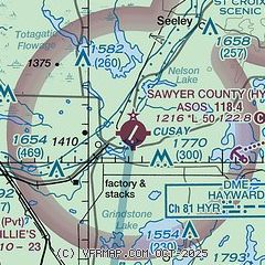
|
| Airport distance calculator |
|---|
|
|
| Sunrise and sunset |
|---|
|
Times for 30-Oct-2025
| | Local
(UTC-5) | | Zulu
(UTC) |
|---|
| Morning civil twilight | | 07:14 | | 12:14 |
| Sunrise | | 07:45 | | 12:45 |
| Sunset | | 17:54 | | 22:54 |
| Evening civil twilight | | 18:25 | | 23:25 |
|
| Current date and time |
|---|
| Zulu (UTC) | 31-Oct-2025 03:32:07 |
|---|
| Local (UTC-5) | 30-Oct-2025 22:32:07 |
|---|
|
| METAR |
|---|
| KHYR | 310308Z AUTO 00000KT 10SM BKN019 BKN033 OVC042 01/01 A2988 RMK AO2 T00110006
|
|
| TAF |
|---|
| KHYR | 302224Z 3022/3118 VRB02KT P6SM OVC050 FM310200 VRB02KT P6SM BKN025 OVC040 FM311500 VRB02KT P6SM BKN022
|
|
| NOTAMs |
|---|
NOTAMs are issued by the DoD/FAA and will open in a separate window not controlled by AirNav.
|
|


