FAA INFORMATION EFFECTIVE 09 JULY 2026
Location
| FAA Identifier: | I40 |
| Lat/Long: | 40-18-36.6000N 081-51-08.7000W
40-18.610000N 081-51.145000W
40.3101667,-81.8524167
(estimated) |
| Elevation: | 978.9 ft. / 298.4 m (surveyed) |
| Variation: | 07W (2000) |
| From city: | 3 miles N of COSHOCTON, OH |
| Time zone: | UTC -4 (UTC -5 during Standard Time) |
| Zip code: | 43812 |
Airport Operations
| Airport use: | Open to the public |
| Control tower: | no |
| ARTCC: | INDIANAPOLIS CENTER |
| FSS: | CLEVELAND FLIGHT SERVICE STATION |
| NOTAMs facility: | CLE (NOTAM-D service available) |
| Attendance: | 0900-1700
FOR SER AFT HRS SEE SIGN IN FBO VESTIBULE FOR CTC INFO. |
| Wind indicator: | yes |
| Segmented circle: | no |
| Lights: | ACTVT REIL RWY 22; MIRL RWY 04/22 - 122.9. PAPI RWY 04 & 22 OPR CONSLY. |
| Beacon: | white-green (lighted land airport)
Operates sunset to sunrise. |
Airport Communications
| CTAF/UNICOM: | 123.0 |
| WX AWOS-3: | 118.875 (740-295-7370) |
| WX AWOS-3 at 10G (14 nm N): | 128.325 (330-674-6279) |
- APCH/DEP SVC PRVDD BY INDIANAPOLIS ARTCC ON FREQS 124.45/323.275 (ZANESVILLE RCAG).
Nearby radio navigation aids
| VOR radial/distance | | VOR name | | Freq | | Var |
|---|
| BSVr221/32.2 | | BRIGGS VOR/DME | | 114.05 | | 04W |
| APEr080/35.0 | | APPLETON VORTAC | | 116.70 | | 06W |
| NDB name | | Hdg/Dist | | Freq | | Var | | ID |
|---|
| CADIZ | | 284/38.7 | | 239 | | 07W | | CFX | -.-. ..-. -..- |
Airport Services
| Fuel available: | 100LL JET-A+
100LL:100LL & JET A+ AVBL FULL SVC FM TRUCK. |
| Parking: | hangars and tiedowns |
| Airframe service: | MAJOR |
| Powerplant service: | MAJOR |
| Bottled oxygen: | NONE |
| Bulk oxygen: | NONE |
Runway Information
Runway 4/22
| Dimensions: | 5001 x 75 ft. / 1524 x 23 m |
| Surface: | asphalt, in good condition |
| Weight bearing capacity: | | Single wheel: | 30.0 | | Double wheel: | 35.0 |
|
| Runway edge lights: | medium intensity |
| RUNWAY 4 | | RUNWAY 22 |
| Latitude: | 40-18.282397N | | 40-18.936983N |
| Longitude: | 081-51.470680W | | 081-50.817750W |
| Elevation: | 973.1 ft. | | 978.6 ft. |
| Traffic pattern: | left | | left |
| Runway heading: | 044 magnetic, 037 true | | 224 magnetic, 217 true |
| Markings: | nonprecision, in fair condition | | nonprecision, in fair condition |
| Visual slope indicator: | 2-light PAPI on left (3.50 degrees glide path) | | 4-light PAPI on right (3.00 degrees glide path)
UNUSBL BYD 8 DEGS L OF CRS. |
| Runway end identifier lights: | no | | yes |
| Touchdown point: | yes, no lights | | yes, no lights |
| Obstructions: | none
+10 BRUSH, 0-150 FT DIST, 105 FT L. | | 21 ft. trees, 378 ft. from runway, 170 ft. left of centerline, 8:1 slope to clear |
Airport Ownership and Management from official FAA records
| Ownership: | Publicly-owned |
| Owner: | COSHOCTON CO RGNL ARPT AUTH
24569 AIRPORT RD
COSHOCTON, OH 43812-9219
Phone 740-622-2252 |
| Manager: | MARTY DOBSON
24569 AIRPORT RD
COSHOCTON, OH 43812-9219
Phone 740-622-2252 |
Additional Remarks
| - | DEER, BIRDS, & OTR WILDLIFE ON & INVOF ARPT. |
| - | GCO AVBL ON FREQ 121.725 INDIANAPOLIS CENTER. |
| - | FOR CD IF UNA VIA GCO CTC INDIANAPOLIS ARTCC AT 317-247-2411. |
Instrument Procedures
NOTE: All procedures below are presented as PDF files. If you need a reader for these files, you should download the free Adobe Reader.NOT FOR NAVIGATION. Please procure official charts for flight.
FAA instrument procedures published for use from 09 July 2026 at 0901Z to 06 August 2026 at 0900Z.
IAPs - Instrument Approach Procedures |
|---|
| RNAV (GPS) RWY 04 | |
download (236KB) |
| RNAV (GPS) RWY 22 | |
download (229KB) |
| NOTE: Special Take-Off Minimums/Departure Procedures apply | |
download (242KB) |
Other nearby airports with instrument procedures:
10G - Holmes County Airport (14 nm N)
KPHD - Harry Clever Field Airport (22 nm NE)
KZZV - Zanesville Municipal Airport (22 nm S)
KCDI - Cambridge Municipal Airport (24 nm SE)
4I3 - Knox County Airport (31 nm W)
|
|

Road maps at:
MapQuest
Bing
Google
| Aerial photo |
|---|
WARNING: Photo may not be current or correct
 Photo courtesy of AirNav, LLC
Photo taken 09-May-2010
Photo courtesy of AirNav, LLC
Photo taken 09-May-2010
Do you have a better or more recent aerial photo of Richard Downing Airport that you would like to share? If so, please send us your photo.
|
| Sectional chart |
|---|
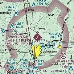
|
| Airport distance calculator |
|---|
|
|
| Sunrise and sunset |
|---|
|
Times for 21-Jul-2026
| | Local
(UTC-4) | | Zulu
(UTC) |
|---|
| Morning civil twilight | | 05:45 | | 09:45 |
| Sunrise | | 06:16 | | 10:16 |
| Sunset | | 20:51 | | 00:51 |
| Evening civil twilight | | 21:23 | | 01:23 |
|
| Current date and time |
|---|
| Zulu (UTC) | 22-Jul-2026 01:15:14 |
|---|
| Local (UTC-4) | 21-Jul-2026 21:15:14 |
|---|
|
| METAR |
|---|
KZZV
22nm S | 220053Z AUTO 00000KT 10SM CLR 23/21 A2971 RMK AO2 LTG DSNT W-N RAE2356 SLP052 P0000 T02280211
|
KPHD
22nm NE | 220053Z AUTO 23005KT 10SM SCT060 BKN120 24/19 A2971 RMK AO2 LTG DSNT SW SLP053 T02390194
|
KCDI
24nm SE | 220055Z AUTO 00000KT 10SM CLR 22/21 A2971 RMK AO2 T02150213
|
K4I3
31nm W | 220055Z AUTO 28007KT 10SM FEW046 OVC060 22/22 A2973 RMK AO2 P0002
|
KVTA
33nm SW | 220054Z AUTO 26007KT 200V330 10SM TS FEW023 SCT042 OVC055 25/21 A2973 RMK AO2 LTG DSNT NE AND E AND W TSB34 PRESRR SLP058 T02500206
|
KBJJ
33nm N | 220056Z AUTO 29005KT 10SM CLR 23/21 A2971 RMK AO2 SLP052 T02280206
|
KCAK
41nm NE | 220051Z 35005KT 10SM FEW030 BKN050 BKN110 24/19 A2970 RMK AO2 SLP047 T02440189
|
KMFD
43nm NW | 220052Z 27007KT 240V310 10SM CLR 24/17 A2973 RMK AO2 SLP058 T02440167 $
|
|
| TAF |
|---|
KZZV
22nm S | 212111Z 2121/2218 22009KT 6SM -TSRA SCT025CB BKN100 FM220000 24008KT P6SM -SHRA SCT015 BKN060 FM220300 25005KT P6SM SCT070
|
|
| NOTAMs |
|---|
NOTAMs are issued by the DoD/FAA and will open in a separate window not controlled by AirNav.
|
|


