FAA INFORMATION EFFECTIVE 25 DECEMBER 2025
Location
| FAA Identifier: | BDU |
| Lat/Long: | 40-02-21.7150N 105-13-33.9225W
40-02.361917N 105-13.565375W
40.0393653,-105.2260896
(estimated) |
| Elevation: | 5288 ft. / 1612 m (estimated) |
| Variation: | 12E (1985) |
| From city: | 3 miles NE of BOULDER, CO |
| Time zone: | UTC -7 (UTC -6 during Daylight Saving Time) |
| Zip code: | 80301 |
Airport Operations
| Airport use: | Open to the public |
| Activation date: | 04/1940 |
| Control tower: | no |
| ARTCC: | DENVER CENTER |
| FSS: | DENVER FLIGHT SERVICE STATION |
| NOTAMs facility: | DEN (NOTAM-D service available) |
| Attendance: | 0800-1700 |
| Pattern altitude: | 6300 ft. MSL |
| Wind indicator: | lighted |
| Segmented circle: | yes |
| Lights: | ACTVT PAPI RWY 26; MIRL RWY 8/26 - CTAF. |
| Beacon: | white-green (lighted land airport)
Operates sunset to sunrise. |
Airport Communications
| CTAF/UNICOM: | 122.725 |
| WX AWOS-3: | 118.825 (303-541-9540) |
| WX AWOS-3 at LMO (8 nm N): | 120.0 (303-684-7545) |
| WX AWOS-3PT at EIK (8 nm E): | 133.825 (303-604-4339) |
| WX AWOS-3 at BJC (9 nm SE): | PHONE 720-887-8067 |
Nearby radio navigation aids
| VOR radial/distance | | VOR name | | Freq | | Var |
|---|
| BJCr321/8.6 | | JEFFCO VOR/DME | | 115.40 | | 11E |
| DVVr279/29.0 | | MILE HIGH VORTAC | | 114.70 | | 08E |
| DENr290/29.4 | | DENVER VOR/DME | | 117.90 | | 08E |
| FQFr296/34.9 | | FALCON VORTAC | | 116.30 | | 11E |
Airport Services
| Fuel available: | 100LL JET-A
100LL:100LL SELF SERVE AVBL H24. |
| Parking: | hangars and tiedowns |
| Airframe service: | MAJOR |
| Powerplant service: | MAJOR |
Runway Information
Runway 8/26
| Dimensions: | 4100 x 75 ft. / 1250 x 23 m |
| Surface: | asphalt, in excellent condition |
| Weight bearing capacity: | | PCN 11 /F/C/X/U | | Single wheel: | 16.0 |
|
| Runway edge lights: | medium intensity |
| Operational restrictions: | GLIDER OPS 60 FT PARL TO RWY. |
| RUNWAY 8 | | RUNWAY 26 |
| Latitude: | 40-02.345333N | | 40-02.345667N |
| Longitude: | 105-14.008000W | | 105-13.129167W |
| Elevation: | 5288.0 ft. | | 5278.8 ft. |
| Traffic pattern: | left | | right |
| Runway heading: | 078 magnetic, 090 true | | 258 magnetic, 270 true |
| Displaced threshold: | 200 ft. | | no |
| Declared distances: | TORA:4100 TODA:4100 ASDA:4100 LDA:3900 | | TORA:4100 TODA:4100 ASDA:3900 LDA:3900 |
| Markings: | basic, in good condition | | basic, in good condition |
| Visual slope indicator: | | | 4-light PAPI on left (3.50 degrees glide path) |
| Touchdown point: | yes, lighted | | yes, lighted |
| Obstructions: | 10 ft. trees, 278 ft. from runway, 44 ft. right of centerline, 7:1 slope to clear
RWY 08 10 FT TREE, DIST 277 FT, 14 FT R, APCH SLP 47:1 DSPLCD THLD. | | none |
Runway 8G/26G
| Dimensions: | 4100 x 20 ft. / 1250 x 6 m
3000 FT X 20 FT CHIP & SEAL W END; 1100 FT GRASS E END. |
| Surface: | asphalt/turf, in fair condition |
| Operational restrictions: | LNDG AREA UNDEFINED; GLIDER OPS ONLY; 197 FT SEPN CNTRLN TO CNTRLN. |
| RUNWAY 8G | | RUNWAY 26G |
| Latitude: | 40-02.378333N | | 40-02.378333N |
| Longitude: | 105-14.001500W | | 105-13.122833W |
| Elevation: | 5287.0 ft. | | 5274.0 ft. |
| Traffic pattern: | left | | right |
| Obstructions: | 56 ft. trees, 806 ft. from runway, 153 ft. left of centerline, 14:1 slope to clear | | none |
Airport Ownership and Management from official FAA records
| Ownership: | Publicly-owned |
| Owner: | CITY OF BOULDER
PO BOX 791
BOULDER, CO 80306
Phone 303-441-3108 |
| Manager: | ERIC VENCES
3327 AIRPORT ROAD
BOULDER, CO 80301
Phone 303-441-3108 |
Additional Remarks
| A30A-08 | DEP TURN BLW 512 FT NA. 40-60 FT TREES RESULT IN 27 DEG OBST CLNC SLOPE TO DTHR. RWY 08 CALM WIND RWY. |
| A30A-26 | DURG W WIND EXP SVR TURB. 300 FT SAFETY AREA OUTLINED WITH RED REFLECTORS; 130 FT DROPOFF E OF MKD AREA. |
| - | PAJA & WATER FOWL ON & INVOF ARPT. |
| - | TPA: RWY 08/26 TPA 1012 FT AGL. |
| - | SIMUL APCH & DEP FM RWY 8/26 & 8G/26G NA; PWRD ACFT YIELD TO GLIDERS ON FNA OR INITIATE GO-AROUND FOR ADEQUATE SPACING. |
| - | MIDFIELD PAT ENTRY FM S GLIDER USE ONLY. |
| - | FOR CD CTC DENVER APCH AT 303-342-1916. |
| - | GLIDER ACT DLY SR-SS SE OF ARPT BTN ARPT & POWER PLANT FM 6300 - 9000 FT; RCMD AVOIDANCE & EXERCIZE EXTREME CTN WHEN TRANSITING AREA. |
| - | SIMUL RWY OPS ON RWY 8/26 AND 8G/26G ARE PROHIBITED. |
| - | 25 - 55 FT TREES OUTLINE HAYDEN LAKE 200 FT FM RWY 08G THR; HAYDEN LAKE 250 FT FM RWY 8 & 8G THR. |
| - | NOISE ABATEMENT PROC IN EFCT - AMGR OR HTTP:/WWW.BOULDERCOLORADO.GOV/AIRPORT. |
Instrument Procedures
There are no published instrument procedures at KBDU.
Some nearby airports with instrument procedures:
KLMO - Vance Brand Airport (8 nm N)
KEIK - Erie Municipal Airport (8 nm E)
KBJC - Rocky Mountain Metro Airport (9 nm SE)
KFNL - Northern Colorado Regional Airport (27 nm N)
KDEN - Denver International Airport (28 nm SE)
|
|

Road maps at:
MapQuest
Bing
Google
| Aerial photo |
|---|
WARNING: Photo may not be current or correct
 Photo by Matt Beyer and Geremy Kornreich
Taken in the Fall of 2017
looking east.
Photo by Matt Beyer and Geremy Kornreich
Taken in the Fall of 2017
looking east.
Do you have a better or more recent aerial photo of Boulder Municipal Airport that you would like to share? If so, please send us your photo.
|
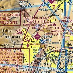
| Sectional chart |
|---|
|
| Airport distance calculator |
|---|
|
|
| Sunrise and sunset |
|---|
|
Times for 05-Jan-2026
| | Local
(UTC-7) | | Zulu
(UTC) |
|---|
| Morning civil twilight | | 06:54 | | 13:54 |
| Sunrise | | 07:24 | | 14:24 |
| Sunset | | 16:49 | | 23:49 |
| Evening civil twilight | | 17:19 | | 00:19 |
|
| Current date and time |
|---|
| Zulu (UTC) | 05-Jan-2026 17:54:26 |
|---|
| Local (UTC-7) | 05-Jan-2026 10:54:26 |
|---|
|
| METAR |
|---|
| K1V5 | AWOS 118.825 303-541-9540
No observation available
|
| KBDU | 051735Z AUTO 24021G28KT 10SM CLR 13/M06 A2977 RMK AO2
|
KLMO
8nm N | 051715Z AUTO 27017G23KT 240V300 10SM CLR 14/M05 A2981 RMK AO2 T01361055
|
KEIK
8nm E | 051715Z AUTO 25016G23KT 10SM CLR 14/M07 A2978 RMK AO2 T01411066
|
KBJC
9nm SE | 051649Z 26011KT 10SM CLR 13/M06 A2980
|
|
| TAF |
|---|
KBJC
9nm SE | 051518Z 0515/0612 VRB06KT P6SM FEW140 BKN200 TEMPO 0515/0517 28015G25KT FM051700 28015G25KT P6SM FEW100 SCT200 TEMPO 0520/0524 27020G35KT FM060300 27012G22KT P6SM FEW200
|
|
| NOTAMs |
|---|
NOTAMs are issued by the DoD/FAA and will open in a separate window not controlled by AirNav.
|
|


