FAA INFORMATION EFFECTIVE 09 JULY 2026
Location
| FAA Identifier: | CVC |
| Lat/Long: | 33-37-56.0910N 083-50-47.8280W
33-37.934850N 083-50.797133W
33.6322475,-83.8466189
(estimated) |
| Elevation: | 819.9 ft. / 249.9 m (surveyed) |
| Variation: | 05W (2010) |
| From city: | 35 miles ESE of ATLANTA, GA |
| Time zone: | UTC -4 (UTC -5 during Standard Time) |
| Zip code: | 30054 |
Airport Operations
| Airport use: | Open to the public |
| Activation date: | 04/1961 |
| Control tower: | no |
| ARTCC: | ATLANTA CENTER |
| FSS: | MACON FLIGHT SERVICE STATION |
| NOTAMs facility: | CVC (NOTAM-D service available) |
| Attendance: | MON-FRI 0800-1700, ALL SAT-SUN 0900-1700 |
| Wind indicator: | lighted |
| Segmented circle: | yes |
| Lights: | ACTVT MALSR RWY 28; PAPI RWY 10 & 28; MIRL RWY 10/28 - CTAF. |
| Beacon: | white-green (lighted land airport)
Operates sunset to sunrise. |
Airport Communications
| CTAF/UNICOM: | 123.0 |
| WX AWOS-3: | 118.725 (770-385-7057) |
| ATLANTA APPROACH: | 128.575 |
| ATLANTA DEPARTURE: | 128.575 |
| WX AWOS-3PT at D73 (12 nm NE): | 120.825 (678-635-3668) |
Nearby radio navigation aids
| VOR radial/distance | | VOR name | | Freq | | Var |
|---|
| AHNr234/32.2 | | ATHENS VOR/DME | | 116.95 | | 00E |
| NDB name | | Hdg/Dist | | Freq | | Var | | ID |
|---|
| BARROW COUNTY | | 220/22.3 | | 404 | | 05W | | BMW | -... -- .-- |
| PECAT | | 063/37.7 | | 316 | | 05W | | FFC | ..-. ..-. -.-. |
Airport Services
| Fuel available: | 100LL JET-A+ |
| Parking: | hangars and tiedowns |
| Airframe service: | MAJOR |
| Powerplant service: | MAJOR |
| Bottled oxygen: | NONE |
| Bulk oxygen: | NONE |
Runway Information
Runway 10/28
| Dimensions: | 6000 x 100 ft. / 1829 x 30 m |
| Surface: | asphalt, in good condition |
| Weight bearing capacity: | |
| Runway edge lights: | medium intensity |
| RUNWAY 10 | | RUNWAY 28 |
| Latitude: | 33-37.982017N | | 33-37.887647N |
| Longitude: | 083-51.385782W | | 083-50.208508W |
| Elevation: | 795.3 ft. | | 819.9 ft. |
| Traffic pattern: | left | | right |
| Runway heading: | 100 magnetic, 095 true | | 280 magnetic, 275 true |
| Displaced threshold: | no | | 500 ft. |
| Declared distances: | TORA:6000 TODA:6000 ASDA:5800 LDA:5800 | | TORA:6000 TODA:6000 ASDA:6000 LDA:5500 |
| Markings: | nonprecision, in good condition | | nonprecision, in good condition |
| Visual slope indicator: | 2-light PAPI on left (4.00 degrees glide path) | | 2-light PAPI on left (3.00 degrees glide path) |
| Approach lights: | | | MALSR: 1,400 foot medium intensity approach lighting system with runway alignment indicator lights |
| Touchdown point: | yes, no lights | | yes, no lights |
| Obstructions: | 40 ft. trees, 707 ft. from runway, 279 ft. left of centerline, 12:1 slope to clear | | 24 ft. pole, 406 ft. from runway, 222 ft. left of centerline, 8:1 slope to clear |
Airport Ownership and Management from official FAA records
| Ownership: | Publicly-owned |
| Owner: | CITY OF COVINGTON
CITY HALL, PO BOX 1527
COVINGTON, GA 30014
Phone 770-385-2000 |
| Manager: | ADAM WEBB
14100 HIGHWAY 142
COVINGTON, GA 30014
Phone 770-787-3996
ARPT PHONE 770-787-0098. |
Additional Remarks
| - | DEER AND MIGRATORY BIRDS ON & INVOF ARPT. |
| - | AVOID OVERFLYING POPULATED AREA SW OF ARPT BLO 1500 FT AGL. |
| - | NO 180 DEGREE TURNS ON ASPH FOR ACFT OVER 12500 LBS GWT. |
| - | FOR CD CTC ATLANTA APCH AT 678-364-6131. |
Instrument Procedures
NOTE: All procedures below are presented as PDF files. If you need a reader for these files, you should download the free Adobe Reader.NOT FOR NAVIGATION. Please procure official charts for flight.
FAA instrument procedures published for use from 09 July 2026 at 0901Z to 06 August 2026 at 0900Z.
STARs - Standard Terminal Arrivals |
|---|
| BUKHD THREE (RNAV) **NEW** | |
download (190KB) |
| DEHAN THREE (RNAV) **NEW** | |
2 pages:
[1] [2] (325KB) |
| SWTEE TWO (RNAV) **NEW** | |
download (142KB) |
IAPs - Instrument Approach Procedures |
|---|
| RNAV (GPS) RWY 10 | |
download (174KB) |
| RNAV (GPS) RWY 28 | |
download (209KB) |
| NOTE: Special Alternate Minimums apply | |
download (159KB) |
| NOTE: Special Take-Off Minimums/Departure Procedures apply | |
download (189KB) |
Other nearby airports with instrument procedures:
D73 - Cy Nunnally Memorial Airport (12 nm NE)
52A - Madison Municipal Airport (19 nm E)
KLZU - Gwinnett County Airport-Briscoe Field (22 nm N)
KWDR - Barrow County Airport (23 nm NE)
KPDK - Dekalb-Peachtree Airport (27 nm NW)
|
|

Road maps at:
MapQuest
Bing
Google
| Aerial photo |
|---|
WARNING: Photo may not be current or correct
 Photo by Tim Vogt
Photo taken 03-Nov-2019
looking southeast.
Photo by Tim Vogt
Photo taken 03-Nov-2019
looking southeast.
Do you have a better or more recent aerial photo of Covington Municipal Airport that you would like to share? If so, please send us your photo.
|
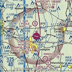
| Sectional chart |
|---|
|
| Airport distance calculator |
|---|
|
|
| Sunrise and sunset |
|---|
|
Times for 24-Jul-2026
| | Local
(UTC-4) | | Zulu
(UTC) |
|---|
| Morning civil twilight | | 06:15 | | 10:15 |
| Sunrise | | 06:43 | | 10:43 |
| Sunset | | 20:41 | | 00:41 |
| Evening civil twilight | | 21:09 | | 01:09 |
|
| Current date and time |
|---|
| Zulu (UTC) | 25-Jul-2026 01:52:48 |
|---|
| Local (UTC-4) | 24-Jul-2026 21:52:48 |
|---|
|
| METAR |
|---|
| KCVC | 250135Z AUTO 00000KT 4SM BR SCT004 SCT008 SCT026 25/25 A3008 RMK AO2
|
KD73
12nm NE | 250135Z AUTO 7SM OVC003 A3010 RMK AO2
|
|
| TAF |
|---|
KPDK
27nm NW | 242157Z 2422/2518 21005KT 5SM -SHRA BR BKN006 PROB30 2508/2513 2SM -SHRA OVC008 FM251700 31007KT P6SM BKN025
|
KATL
30nm W | 242155Z 2422/2524 28006KT P6SM -SHRA SCT030 BKN050 FM250200 VRB03KT P6SM VCSH BKN060 FM250700 VRB03KT 5SM BR SCT008 BKN012 PROB30 2509/2514 5SM -SHRA BR BKN008 FM251600 31007KT P6SM BKN025 FM252000 31007KT P6SM VCSH SCT030
|
KAHN
32nm NE | 242200Z 2422/2518 10004KT P6SM -SHRA BKN006 BKN080 TEMPO 2422/2424 2SM BR OVC003 FM250000 00000KT P6SM -SHRA BKN030 FM250100 00000KT 5SM BR BKN015 PROB30 2503/2508 2SM -SHRA OVC004 FM251700 31006KT P6SM SCT025
|
|
| NOTAMs |
|---|
NOTAMs are issued by the DoD/FAA and will open in a separate window not controlled by AirNav.
|
|


